Share to: share facebook share twitter share wa share telegram print page


Tangkak District

Tangkak District
Daerah Tangkak
Other transcription(s)
 • Jawiتڠكق
 • Chinese東甲縣
 • Tamilதங்காக்
Flag of Tangkak District
Motto(s): 
Berusaha untuk Makmur (in Malay)
"Striving to Prosper"
Location of Tangkak District in Johor
Map
Tangkak District is located in Malaysia
Tangkak District
Tangkak District
Location of Tangkak District in Malaysia
Coordinates: 2°16′N 102°33′E / 2.267°N 102.550°E / 2.267; 102.550
Country Malaysia
State Johor
SeatTangkak
Local area government(s)Tangkak District Council
Government
 • District officerHaji Shafiei bin Ahamad
Area
 • Total
970.24 km2 (374.61 sq mi)
Population
 (2020)[2]
 • Total
163,449
 • Density170/km2 (440/sq mi)
Time zoneUTC+8 (MST)
 • Summer (DST)UTC+8 (Not observed)
Postcode
849xx
Calling code+6-06
Vehicle registration platesJ
Tangkak District Council

The Tangkak District is a district in western Johor, Malaysia, bordering Muar District to the south, Segamat District to the northeast, and Jasin District, Malacca to the west. The district also shares an 11 kilometre border with Tampin District, Negeri Sembilan to the northwest. The district capital and largest settlement is the town of Tangkak. Other towns include Sagil, Sungai Mati and Tanjung Agas.

Geography

Mount Ledang, the prominent landmark of the district. Seen from downtown Tangkak.

Along with Muar, Batu Pahat and Segamat, Tangkak District is one of the districts that constitute the northern part of Johor. The Muar River delineates the boundary with Muar District to its south, from Durian Chondong in the east towards Tanjung Agas on the Malacca Strait coast. To its northeast, the district's famed landmark, Mount Ledang, is situated close to the tripoint between the neighbouring states of Malacca and Negeri Sembilan, where it is the highest point statewide at 1,276 metres (4,186 ft).

History

The district was previously an autonomous sub-district (daerah kecil) covering the north-western part of the Muar District, separated from Muar Town proper by the Muar River.[3] A ceremony headed by the sultan on 9 June 2008 saw the official proclamation of that part becoming Johor's 10th district, then named Ledang District after the eponymous mountain located within its borders.[4] The district was then renamed Tangkak District at the end of 2015 by a decree of Sultan Ibrahim to preserve the historical value of traditional name of places in the state.[5][6][7]

Administrative divisions
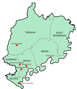
Tangkak District is divided into:

Mukims

  • Bukit Serampang
  • Grisek
  • Kesang
  • Kundang
  • Serom
  • Tangkak

Towns (Bandar)

Hamlets (Pekan)

  • Grisek

Townships

Demographics

Historical population
YearPop.±%
2010 131,890—    
2020 163,449+23.9%
Figures before 2008 is included under Muar District.
Source: [8]

Federal Parliament and State Assembly Seats


List of Tangkak district representatives in the Federal Parliament (Dewan Rakyat)

Parliament Seat Name Member of Parliament Party
P143 Pagoh Muhyiddin Yassin Perikatan Nasional (BERSATU)
P144 Ledang Syed Ibrahim Syed Noh Pakatan Harapan (PKR)


List of Tangkak district representatives in the State Legislative Assembly (Dewan Negeri)

Parliament State Seat Name State Assemblyman Party
P143 N7 Bukit Kepong Sahruddin Jamal Perikatan Nasional (BERSATU)
P144 N9 Gambir Sahrihan Jani Barisan Nasional (UMNO)
P144 N10 Tangkak Ee Chin Li Pakatan Harapan (DAP)
P144 N11 Serom Khairin Nisa Ismail Barisan Nasional (UMNO)

Economy

The main economy activities in the district are lifestyle tourism, adventure sports, light manufacturing and agriculture.[9] Main industrial areas in the district are Desa Serom, Desa Sungai Mati, Gerisek, Sagil and Tangkak Industrial Areas.[10]

Tourist attractions

Mount Ledang National Park

A waterfall in Gunung Ledang National Park

One of the main tourist attractions of Tangkak is the Gunung Ledang National Park. The park is situated 170 km from Johor Bahru and has an area of 107 km2. The park has two entry points, one in Sagil and the other in Asahan, from the Malaccan side. Mount Ledang's peak, which is 1,276 m above sea level, is the highest point in Johor and has been frequently climbed by many people all year round. Sagil Falls, which is also in the park is a famous picnic site. Mount Ledang is also widely recognised as a friendly training venue for amateur (or beginners) mountain hikers/climbers.

See also

References

  1. ^ "Profil Daerah". ptj.johor.gov.my.
  2. ^ "Population Distribution and Basic Demographic Characteristics, 2010" (PDF). Department of Statistics, Malaysia. Archived from the original (PDF) on 22 May 2014. Retrieved 19 April 2012.
  3. ^ "Ledang becomes 10th district". Archived from the original on 5 October 2012.
  4. ^ "Ledang set to become Johor's newest district". The Star Online. Star Media Group Berhad. 1 June 2008. Retrieved 24 July 2016.
  5. ^ "Johor's administrative capital Nusajaya to be renamed Iskandar Puteri". Straits Times. Singapore Press Holdings Ltd. 7 December 2015. Retrieved 24 July 2016.
  6. ^ Zazali Musa (7 December 2015). "Nusajaya to be renamed Iskandar Puteri". The Star Online. Retrieved 16 March 2019.
  7. ^ Ben Tan (7 December 2015). "Name changes for Johor districts". The Rakyat Post. Retrieved 16 March 2019.
  8. ^ "Key Findings of Population and Housing Census of Malaysia 2020" (pdf) (in Malay and English). Department of Statistics, Malaysia. ISBN 978-967-2000-85-3.
  9. ^ "Muafakat ke Arah #Johor Berkemajuan" (PDF). Muafakat Johor (in Malay). Retrieved 17 March 2018.
  10. ^ Handbook johor.gov.my
Kembali kehalaman sebelumnya


Index: pl ar de en es fr it arz nl ja pt ceb sv uk vi war zh ru af ast az bg zh-min-nan bn be ca cs cy da et el eo eu fa gl ko hi hr id he ka la lv lt hu mk ms min no nn ce uz kk ro simple sk sl sr sh fi ta tt th tg azb tr ur zh-yue hy my ace als am an hyw ban bjn map-bms ba be-tarask bcl bpy bar bs br cv nv eml hif fo fy ga gd gu hak ha hsb io ig ilo ia ie os is jv kn ht ku ckb ky mrj lb lij li lmo mai mg ml zh-classical mr xmf mzn cdo mn nap new ne frr oc mhr or as pa pnb ps pms nds crh qu sa sah sco sq scn si sd szl su sw tl shn te bug vec vo wa wuu yi yo diq bat-smg zu lad kbd ang smn ab roa-rup frp arc gn av ay bh bi bo bxr cbk-zam co za dag ary se pdc dv dsb myv ext fur gv gag inh ki glk gan guw xal haw rw kbp pam csb kw km kv koi kg gom ks gcr lo lbe ltg lez nia ln jbo lg mt mi tw mwl mdf mnw nqo fj nah na nds-nl nrm nov om pi pag pap pfl pcd krc kaa ksh rm rue sm sat sc trv stq nso sn cu so srn kab roa-tara tet tpi to chr tum tk tyv udm ug vep fiu-vro vls wo xh zea ty ak bm ch ny ee ff got iu ik kl mad cr pih ami pwn pnt dz rmy rn sg st tn ss ti din chy ts kcg ve 
Prefix: a b c d e f g h i j k l m n o p q r s t u v w x y z 0 1 2 3 4 5 6 7 8 9