Share to: share facebook share twitter share wa share telegram print page


Sonora Pass

Sonora Pass
Elevation9,624 ft (2,933 m)
Traversed by SR 108
LocationMono / Tuolumne / Alpine counties, California, United States[1]
RangeSierra Nevada
Coordinates38°19′40″N 119°38′9″W / 38.32778°N 119.63583°W / 38.32778; -119.63583
Sonora Pass is located in California
Sonora Pass
Location in California

Sonora Pass (el. 9,624 ft. / 2,933 m.) is a mountain pass in the Sierra Nevada in California. It is the second-highest pass with a road in California and in the Sierra Nevada.[2] It is 321 feet (98 m) lower than Tioga Pass to the south.[3] State Route 108 traverses the pass, as does the Pacific Crest Trail.

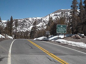
Pass sign, eastbound
Sonora pass with fresh snow as seen from near Wheeler Peak

Description

The pass connects the communities of Sonora to the west and Bridgeport to the east. Like Ebbetts Pass to the north and Tioga Pass to the south, the highway closes during winter, generally between November and May, due to snow accumulation.[4]

The highway over the pass is extremely steep (exceeding 8% for most of the traverse, and up to 26% grades in some locations), narrow and winding between Kennedy Meadows on the west side and Leavitt Meadows on the east; unlike most Sierra Nevada road passes, the approach from the west is steep just like the eastern approach. The route is not recommended for vehicles or vehicle combinations that are unusually wide, heavy or long.[5]

View of the Sierra Nevada range and Sonora Peak looking northward from Sonora Pass.

The Pacific Crest Trail, a 2,650 mile (4,240 km) long National Scenic Trail, crosses Highway 108 at Sonora Pass.[6]

Adjacent to the Pass is a picnic/parking area, which serves as a day-use rest stop or a trailhead for hikes to nearby Sonora Peak, Wolf Creek Lake, and other spots north or south along the Pacific Crest Trail.

History

The first documented immigrant traverse of Sonora Pass appears to have been in the late summer of 1852 by a wagon train known as the Clark-Skidmore Company. Subsequently, merchant interests in the communities of Sonora and Columbia promoted the route to California-bound immigrants, not always with happy results when immigrants discovered how difficult it was.[7] There are some references indicating the earliest immigrant crossing was in 1841 by the Bartleson-Bidwell Party, but the U.S. Forest Service indicates they crossed north of Sonora Pass in the Carson-Iceberg area.[8][9]

With the discovery of deposits and development of silver and gold mining east of the Sierra Nevada in the beginning of the 1860s, merchant interests in the counties on both sides of the pass pushed for development of a road that would enable them to improve transportation and trade. Surveying for a road through Sonora Pass began in 1863 and the road was in use by 1865.[10]

In the 1880s the California and Nevada Railroad and its predecessor, the California and Mount Diablo Railroad, proposed to run a narrow gauge railroad over Sonora Pass with a line running from Emeryville - Stockton and then connecting with the Denver and Rio Grande Railroad in Utah. The railroad never built track beyond the San Francisco Bay Area.

The Baker Highway Maintenance Station, on 108 to the west of the summit, kept the road open during the summer; it is closed in the winter, and is listed on the National Register of Historic Places.

In 1935, MGM Art Director David Townsend was killed when the car he was riding in left the road at Sonora Pass. Lowell L. Ralph, Mrs. Lottie Mundello, and Miss Agnes McMullen survived after being thrown from the car. They were there scouting filming locations for the upcoming film Robin Hood of El Dorado (film).

In 1943, the location scenes for the mountainous hideout of the Republican Spanish guerilla band in For Whom the Bell Tolls were filmed here.

Climate

According to the Köppen Climate Classification system, Sonora Pass has a warm-summer mediterranean continental climate, abbreviated "Dsb" on climate maps. The hottest temperature recorded in Sonora Pass was 90 °F (32.2 °C) on July 18, 1988, while the coldest temperature recorded was −16 °F (−26.7 °C) on February 5, 1989.[11]

Climate data for Sonora Pass, California, 1991–2020 normals, extremes 1983–present
Month Jan Feb Mar Apr May Jun Jul Aug Sep Oct Nov Dec Year
Record high °F (°C) 58
(14)
60
(16)
61
(16)
71
(22)
79
(26)
84
(29)
90
(32)
85
(29)
81
(27)
75
(24)
65
(18)
56
(13)
90
(32)
Mean maximum °F (°C) 51.3
(10.7)
50.7
(10.4)
54.6
(12.6)
60.3
(15.7)
66.9
(19.4)
75.4
(24.1)
79.9
(26.6)
77.8
(25.4)
73.4
(23.0)
66.9
(19.4)
57.6
(14.2)
50.1
(10.1)
80.5
(26.9)
Mean daily maximum °F (°C) 37.1
(2.8)
36.7
(2.6)
41.2
(5.1)
45.7
(7.6)
53.5
(11.9)
63.5
(17.5)
71.6
(22.0)
70.5
(21.4)
63.5
(17.5)
53.1
(11.7)
43.0
(6.1)
36.3
(2.4)
51.3
(10.7)
Daily mean °F (°C) 28.3
(−2.1)
27.5
(−2.5)
31.0
(−0.6)
34.9
(1.6)
42.4
(5.8)
51.1
(10.6)
58.7
(14.8)
57.8
(14.3)
51.5
(10.8)
42.3
(5.7)
33.7
(0.9)
27.7
(−2.4)
40.6
(4.7)
Mean daily minimum °F (°C) 19.5
(−6.9)
18.2
(−7.7)
20.9
(−6.2)
24.1
(−4.4)
31.2
(−0.4)
38.5
(3.6)
45.7
(7.6)
45.0
(7.2)
39.6
(4.2)
31.5
(−0.3)
24.3
(−4.3)
19.1
(−7.2)
29.8
(−1.2)
Mean minimum °F (°C) 1.2
(−17.1)
1.8
(−16.8)
5.2
(−14.9)
8.6
(−13.0)
18.0
(−7.8)
25.6
(−3.6)
35.8
(2.1)
35.6
(2.0)
27.0
(−2.8)
16.3
(−8.7)
6.1
(−14.4)
0.7
(−17.4)
−4.1
(−20.1)
Record low °F (°C) −22
(−30)
−16
(−27)
−12
(−24)
−3
(−19)
5
(−15)
14
(−10)
23
(−5)
24
(−4)
18
(−8)
0
(−18)
−12
(−24)
−25
(−32)
−25
(−32)
Average precipitation inches (mm) 6.44
(164)
5.72
(145)
5.49
(139)
3.00
(76)
1.77
(45)
0.67
(17)
0.77
(20)
0.51
(13)
0.70
(18)
1.94
(49)
3.34
(85)
5.73
(146)
36.08
(917)
Average extreme snow depth inches (cm) 54.2
(138)
66.9
(170)
79.0
(201)
70.2
(178)
44.4
(113)
11.5
(29)
0.0
(0.0)
0.0
(0.0)
0.4
(1.0)
3.1
(7.9)
16.5
(42)
35.5
(90)
83.2
(211)
Average precipitation days (≥ 0.01 in) 10.3 11.0 12.0 10.1 6.7 3.1 2.3 2.4 3.2 4.7 8.0 10.2 84
Source: National Weather Service (snow depth 2006–2020)[11]

References

  1. ^ "Sonora Pass, CA". USGS Quad maps. TopoQuest.com. Retrieved 2008-09-20.
  2. ^ "Highways and Major Roads Through the Sierra Nevada". Sierra Nevada Photos. Archived from the original on 2009-05-17. Retrieved 2008-09-20.
  3. ^ "Highways and Major Roads Through the Sierra Nevada". Sierra Nevada Photos. Archived from the original on 2009-05-17. Retrieved 2008-09-20.
  4. ^ "Winter Driving Tips". Caltrans. Retrieved 2023-01-02.
  5. ^ "Picture of advisory sign on State Route 108". Retrieved 2008-09-20.
  6. ^ "Sonora Pass, CA". USGS Quad maps. TopoQuest.com. Retrieved 2008-09-20.
  7. ^ "Sonora Pass". Archived from the original on July 25, 2008. Retrieved 2008-09-20.
  8. ^ "Recreation Activities: Carson-Iceberg Wilderness". US Forest Service. Retrieved 2008-09-20.
  9. ^ "Sonora Pass, Mono County, California". Retrieved 2008-09-20.
  10. ^ Farquhar, Francis Peloubet (1965). History of the Sierra Nevada. University of California Press. p. 102. ISBN 0-520-01551-7. Retrieved 2008-09-20. sonora pass railroad.
  11. ^ a b "NOAA Online Weather Data – NWS Reno". National Weather Service. Retrieved February 23, 2023.
Kembali kehalaman sebelumnya


Index: pl ar de en es fr it arz nl ja pt ceb sv uk vi war zh ru af ast az bg zh-min-nan bn be ca cs cy da et el eo eu fa gl ko hi hr id he ka la lv lt hu mk ms min no nn ce uz kk ro simple sk sl sr sh fi ta tt th tg azb tr ur zh-yue hy my ace als am an hyw ban bjn map-bms ba be-tarask bcl bpy bar bs br cv nv eml hif fo fy ga gd gu hak ha hsb io ig ilo ia ie os is jv kn ht ku ckb ky mrj lb lij li lmo mai mg ml zh-classical mr xmf mzn cdo mn nap new ne frr oc mhr or as pa pnb ps pms nds crh qu sa sah sco sq scn si sd szl su sw tl shn te bug vec vo wa wuu yi yo diq bat-smg zu lad kbd ang smn ab roa-rup frp arc gn av ay bh bi bo bxr cbk-zam co za dag ary se pdc dv dsb myv ext fur gv gag inh ki glk gan guw xal haw rw kbp pam csb kw km kv koi kg gom ks gcr lo lbe ltg lez nia ln jbo lg mt mi tw mwl mdf mnw nqo fj nah na nds-nl nrm nov om pi pag pap pfl pcd krc kaa ksh rm rue sm sat sc trv stq nso sn cu so srn kab roa-tara tet tpi to chr tum tk tyv udm ug vep fiu-vro vls wo xh zea ty ak bm ch ny ee ff got iu ik kl mad cr pih ami pwn pnt dz rmy rn sg st tn ss ti din chy ts kcg ve 
Prefix: a b c d e f g h i j k l m n o p q r s t u v w x y z 0 1 2 3 4 5 6 7 8 9