Share to: share facebook share twitter share wa share telegram print page


San Joaquin Hills

San Joaquin Hills
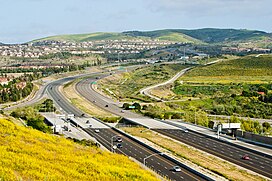
State Route 73 climbs into the San Joaquin Hills, as seen looking southward from University Hills, Irvine
Highest point
PeakSignal Peak
Elevation1,168 ft (356 m)
Geography
San Joaquin Hills is located in California
San Joaquin Hills
San Joaquin Hills
location of San Joaquin Hills in California[1]
San Joaquin Hills is located in the United States
San Joaquin Hills
San Joaquin Hills
San Joaquin Hills (the United States)
CountryUnited States
StateCalifornia
RegionPeninsular Ranges
DistrictOrange County
Range coordinates33°36′42.081″N 117°48′33.198″W / 33.61168917°N 117.80922167°W / 33.61168917; -117.80922167
Borders onSanta Ana Mountains
Topo mapUSGS Laguna Beach

The San Joaquin Hills are a low mountain range of the Peninsular Ranges System, located in coastal Orange County, California.[1]

They extend in a northwest–southeast direction, starting in the northwest in Newport Beach at the southern edge of the Los Angeles Basin, and extending southeast to San Juan Capistrano.

Geography

Geology

The main ridge of the San Joaquin Hills runs southeast from the Upper Newport Bay area, attaining its maximum height of roughly 1,000 feet (300 m) near Laguna Beach. Many of the high ridges exceed 600 to 800 feet (180 to 240 m) in height. The hills stretch over a distance of about 16 miles (26 km) and can be up to 3 to 4 miles (4.8 to 6.4 km) broad. In many places, the San Joaquin Hills drop directly into the Pacific Ocean, creating the steep sea cliffs that characterize the region.

Streams that originate on the west slope of the range include Buck Gully, Los Trancos Creek, Muddy Creek, El Moro Creek, Emerald Creek, Prima Deshecha Cañada, Segunda Deshecha Cañada, and Christianitos Canyon. The east side is drained by Bonita Creek, Sand Canyon Wash, San Joaquin Wash, and La Cañada Wash. Cities bordering the range include Newport Beach, Irvine, Laguna Hills, Aliso Viejo, Laguna Beach, Laguna Niguel, Dana Point, San Juan Capistrano, and San Clemente.

Scientists have suggested that the San Joaquin Hills have been formed by uplift [2] from a blind thrust fault line lying eight miles below the hills similar to the one that produced the 1994 Northridge Earthquake.[3]

Because of erosion phenomena during the previous Ice Age, the San Joaquin Hills are not one continuous mountain range, but instead are bisected by numerous water gaps cut by rivers flowing southwest from the Santa Ana Mountains. In the north, Newport Bay was formed by the Santa Ana River switching its course to the south, cutting across the northern part of the range. Laguna Canyon was formed by San Diego Creek, but eventually the larger creek changed course and left a wind gap through the hills. The largest canyon by far is Aliso Canyon, cut by Aliso Creek. Further south, the hills dissipate into smaller ridges and are bisected by the canyon of Salt Creek. The southern extent of the hills are cut by San Juan Creek.

Named summits

Named summits in the San Joaquin Hills include (from north to south) French Hill in Turtle Rock, Irvine; Signal Peak and Pelican Hill, both of which are near the Newport Coast neighborhood of Newport Beach; Temple Hill in Laguna Beach, more commonly known as "Top of the World" after the neighborhood on its peak; and Niguel Hill in Laguna Niguel.[4]

Flora and fauna

The native vegetation of the hills is in the California coastal sage and chaparral and California chaparral and woodlands ecoregions, largely coastal sage scrub, but other habitat types include grasslands, oak woodlands, wetlands, and riparian habitats along several streams.[5]

In past ages the land that is now the San Joaquin Hills lay under the ocean: construction for the San Joaquin Hills Toll Road unearthed a number of artifacts and more than 40,000 fossils, up to 35 million years old, including 5-million-year-old fossilized whales.[6]

History

Prior to the arrival of Europeans in the area, residents of the nearby Tongva and Acjachemen village of Genga frequented the hills.[7]

The hills take their name from Rancho San Joaquin, owned by Jose Andres Sepulveda. Formed in 1842 by the merger of two smaller ranches, this ranch included the northern part of the hills and likely had Laguna Canyon as its southeastern boundary. Rancho San Joaquin later became part of the Irvine Ranch.[8] Mexican Rancho Niguel was located in the southeastern section of the hills.

The San Joaquin Hills blind thrust may be the source of the earliest recorded earthquake in California, a large earthquake felt in what is now northern Orange County on July 28, 1769, by Gaspar de Portolá.[9]

Development

Two neighborhoods within the San Joaquin Hills take the name of the hills for their own: San Joaquin Hills in Newport Beach, a former census-designated place annexed by that city, and San Joaquin Hills in Laguna Niguel, a master-planned community in that city. Other neighborhoods set in and named after hills in this range include University Hills and Turtle Rock in Irvine.

State Route 73, also called the San Joaquin Hills Toll Road, extends through the length of the hills from Newport Beach to San Juan Capistrano. State Route 133 crosses the hills through Laguna Canyon in Laguna Beach, and they are also crossed in several other places by less major roads.

See also

References

  1. ^ a b "San Joaquin Hills". Geographic Names Information System. United States Geological Survey, United States Department of the Interior. Retrieved 2009-05-04.
  2. ^ Grant, Lisa B.; Mueller, Karl J.; Gath, Eldon M.; Cheng, Hai; Edwards, R. Lawrence; Munro, Rosalind; Kennedy, George L. (1999), "Late Quaternary uplift and earthquake potential of the San Joaquin Hills, southern Los Angeles Basin, California", Geology, 27 (11): 1031–1034, doi:10.1130/0091-7613(1999)027<1031:LQUAEP>2.3.CO;2.
  3. ^ Robbins, Gary (March 11, 1999), Fault found beneath San Joaquin Hills: The 23-mile-long system is similar to the one that produced the Northridge shaker, Orange County Register; Robbins, Gary (November 1, 2001), Scientists to evaluate seismic threat in San Joaquin Hills, Orange County Register; Orange County's Hills Hold Key To Earthquake Findings, KNBC, April 15, 2004; County at risk for Northridge-size quakes say UCI researchers, Orange County Register, April 22, 2004.
  4. ^ U.S. Geological Survey Geographic Names Information System: French Hill, elevation 397 ft. / 121 m. U.S. Geological Survey Geographic Names Information System: Signal Peak, elevation 1161 ft. / 354 m. U.S. Geological Survey Geographic Names Information System: Pelican Hill, elevation 725 ft. / 221 m. U.S. Geological Survey Geographic Names Information System: Temple Hill, elevation 1007 ft. / 307 m. U.S. Geological Survey Geographic Names Information System: Niguel Hill, elevation 935 ft. / 285 m. (prior to grading for real estate development).
  5. ^ Aliso and Wood Canyons Wilderness Park Archived 2006-11-10 at the Wayback Machine open house booklet, Orange County Park System, 2006.
  6. ^ Roan, Shari (November 19, 1989), San Joaquin tollway work breaks historical ground, Orange County Register; Downey, Cheryl (April 28, 1993), Fine whale skeletons unearthed: Paleontologists discover nearly intact skeletons along route of San Joaquin Hills toll road, Orange County Register; Downey, Cheryl (May 11, 1993), A window to our past: Scientists who are checking the San Joaquin Hills tollway route remove and preserve fossils millions of years old before construction starts, Orange County Register; Brennan, Pat (June 18, 1993), Fossil whale makes a delicate journey to county museum: Five million-year-old `Bones' is carefully loaded onto a truck for its trip to Buena Park, Orange County Register; Brennan, Pat (April 4, 1998), Highway to history: Bones reveal a scenic road through the county's past, Orange County Register; Chang, Daniel (May 1, 1999), Dig this!, Orange County Register; Peralta, Jessica (May 17, 2002), Bones about it: Toll road construction unearths fossil treasure trove for school lectures, Orange County Register.
  7. ^ Koerper, Henry; Mason, Roger; Peterson, Mark (2002). Catalysts to complexity : late Holocene societies of the California coast. Jon Erlandson, Terry L. Jones, Jeanne E. Arnold, Cotsen Institute of Archaeology at UCLA. Los Angeles: Cotsen Institute of Archaeology at UCLA. p. 64. ISBN 978-1-938770-67-8. OCLC 745176510.
  8. ^ Goetz, Peggy (June 13, 2002), History buff likes telling the story of Jose Sepulveda, Irvine World News[permanent dead link].
  9. ^ Grant, Lisa B.; Ballenger, Leslie J.; Runnerstrom, Eric E. (2002), "Coastal Uplift of the San Joaquin Hills, Southern Los Angeles Basin, California, by a Large Earthquake since A.D. 1635", Bulletin of the Seismological Society of America, 92 (2): 590–599, doi:10.1785/0120010119; Coledan, Stefano (April 2002), "California Earthquake Described By 18th Century Spanish Explorer", Popular Mechanics, archived from the original on 2008-08-29. Listed by the United States Geological Survey as the earliest recorded earthquake in California on their Earthquake Facts Archived 2009-02-26 at the Wayback Machine web page.
Kembali kehalaman sebelumnya


Index: pl ar de en es fr it arz nl ja pt ceb sv uk vi war zh ru af ast az bg zh-min-nan bn be ca cs cy da et el eo eu fa gl ko hi hr id he ka la lv lt hu mk ms min no nn ce uz kk ro simple sk sl sr sh fi ta tt th tg azb tr ur zh-yue hy my ace als am an hyw ban bjn map-bms ba be-tarask bcl bpy bar bs br cv nv eml hif fo fy ga gd gu hak ha hsb io ig ilo ia ie os is jv kn ht ku ckb ky mrj lb lij li lmo mai mg ml zh-classical mr xmf mzn cdo mn nap new ne frr oc mhr or as pa pnb ps pms nds crh qu sa sah sco sq scn si sd szl su sw tl shn te bug vec vo wa wuu yi yo diq bat-smg zu lad kbd ang smn ab roa-rup frp arc gn av ay bh bi bo bxr cbk-zam co za dag ary se pdc dv dsb myv ext fur gv gag inh ki glk gan guw xal haw rw kbp pam csb kw km kv koi kg gom ks gcr lo lbe ltg lez nia ln jbo lg mt mi tw mwl mdf mnw nqo fj nah na nds-nl nrm nov om pi pag pap pfl pcd krc kaa ksh rm rue sm sat sc trv stq nso sn cu so srn kab roa-tara tet tpi to chr tum tk tyv udm ug vep fiu-vro vls wo xh zea ty ak bm ch ny ee ff got iu ik kl mad cr pih ami pwn pnt dz rmy rn sg st tn ss ti din chy ts kcg ve 
Prefix: a b c d e f g h i j k l m n o p q r s t u v w x y z 0 1 2 3 4 5 6 7 8 9