Share to: share facebook share twitter share wa share telegram print page


Sabangau National Park

Sabangau National Park
Sabangau River and surrounding peat swamp forests
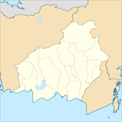
Map showing the location of Sabangau National Park
Location of Sabangau National Park in Borneo
Map showing the location of Sabangau National Park
Sabangau National Park (Kalimantan)
Map showing the location of Sabangau National Park
Sabangau National Park (Indonesia)
LocationCentral Kalimantan, Indonesia
Nearest cityPalangka Raya
Coordinates2°35′S 113°40′E / 2.583°S 113.667°E / -2.583; 113.667
Area5,687 km2 (2,196 sq mi)[1]
Established2004[1]
Governing bodyMinistry of Forestry

Sabangau National Park (sometimes spelled Sebangau) is a national park in Central Kalimantan, a province of Indonesia in Kalimantan, the Indonesian part of the island of Borneo established in 2004. Between 1980 and 1995 the site was a massive logging concessions area. After 1995, the park became a site for illegal logging, which resulted in up to 85 percent of the 568,700-hectare total park area being destroyed. By 2012, less than 1 percent of the park's total area has been reforested and at the current rate, it will take several centuries to restore it to its pre-logged state.[2]

Geography

The national park is centered on Sabangau River, a blackwater river. It flows through the Kelompok Hutan Kahayan or Sabangau peat swamp forest (5,300 km2), between the Katingan and Kahayan rivers. The peat swamp forest is a dual ecosystem, with diverse tropical trees standing on a 10m - 12m layer of peat - partly decayed and waterlogged plant material - which in turn covers relatively infertile soil.

Orangutan in Sabah, Borneo

The severely degraded eastern part of the forest, between the Sabangau and the Kayahan, is officially designated for agriculture. However, since the failure of the Mega Rice Project, which drained large areas of peat forest in an attempt to create rice paddies, no further efforts are being made to make it suitable for this purpose.[3][4]

The forest has been damaged by legal and illegal forestry. There is no longer any continuous forest cover where orangutans may cross the river. A satellite view shows a grid of logging roads throughout most of the forest.

However, the western part is now protected as either National Park or National Laboratory Research Area. A study of the area shows that the hydrological integrity of the forest has been maintained, and it is therefore ecologically resilient,[5] although since it is close to the regional capital Palangkaraya it remains at risk.

Ecology

The forest is home to the world’s largest orangutan population, estimated at 6,910 individuals in 2003, and other rare or unique species. The total agile gibbon population in the Sabangau catchment is estimated to be in the tens of thousands, but is declining fast.[6] Efforts are underway to establish long-term ecological monitoring in the forest.[7][8]

Vulnerable bird species include the large green pigeon (Treron capellei) and possibly Storm's stork (Ciconia stormi) and lesser adjutant (Leptoptilus javanicus).[9] Some 150,000 ha of swamp forest has been recognised as an Important Bird Area (IBA) by BirdLife International.[10]

References

  1. ^ a b "Profile of Sabangau National Park" (in Indonesian). TN Sebangau.com. Retrieved 14 December 2021.
  2. ^ "Can Heavily Deforested Sebangau National Park Be Saved?". 21 July 2012. Archived from the original on 6 August 2012.
  3. ^ orangutantrop.com: Sabangau Forest
  4. ^ Ecological Impact of the One Million Hectare Rice Project in Cantral Kalimantan, Indonesia, Using Remote Sensing and GIS. Boehm, H-D.V. and Siegert, F.
  5. ^ IMPLICATIONS OF GROUNDWATER LEVEL FLUCTUATIONS FOR A TROPICAL PEATLAND ECOSYSTEM IN SOUTHEAST ASIA
  6. ^ Density and population estimate of gibbons (Hylobates albibarbis) in the Sabangau catchment, Central Kalimantan, Indonesia Archived March 26, 2009, at the Wayback Machine
  7. ^ The Orangutan Tropical Peatland Research Project:Monitoring ape populations in the Sabangau Forest, Central Kalimantan, Indonesia
  8. ^ THE IMPORTANCE OF ECOLOGICAL MONITORING FOR HABITAT MANAGEMENT - A CASE STUDY IN THE SABANGAU FOREST, CENTRAL KALIMANTAN, INDONESIA
  9. ^ Birdlife.org Hutan Kahayan
  10. ^ "Hutan Kahayan". BirdLife Data Zone. BirdLife International. 2024. Retrieved 20 August 2024.
Kembali kehalaman sebelumnya


Index: pl ar de en es fr it arz nl ja pt ceb sv uk vi war zh ru af ast az bg zh-min-nan bn be ca cs cy da et el eo eu fa gl ko hi hr id he ka la lv lt hu mk ms min no nn ce uz kk ro simple sk sl sr sh fi ta tt th tg azb tr ur zh-yue hy my ace als am an hyw ban bjn map-bms ba be-tarask bcl bpy bar bs br cv nv eml hif fo fy ga gd gu hak ha hsb io ig ilo ia ie os is jv kn ht ku ckb ky mrj lb lij li lmo mai mg ml zh-classical mr xmf mzn cdo mn nap new ne frr oc mhr or as pa pnb ps pms nds crh qu sa sah sco sq scn si sd szl su sw tl shn te bug vec vo wa wuu yi yo diq bat-smg zu lad kbd ang smn ab roa-rup frp arc gn av ay bh bi bo bxr cbk-zam co za dag ary se pdc dv dsb myv ext fur gv gag inh ki glk gan guw xal haw rw kbp pam csb kw km kv koi kg gom ks gcr lo lbe ltg lez nia ln jbo lg mt mi tw mwl mdf mnw nqo fj nah na nds-nl nrm nov om pi pag pap pfl pcd krc kaa ksh rm rue sm sat sc trv stq nso sn cu so srn kab roa-tara tet tpi to chr tum tk tyv udm ug vep fiu-vro vls wo xh zea ty ak bm ch ny ee ff got iu ik kl mad cr pih ami pwn pnt dz rmy rn sg st tn ss ti din chy ts kcg ve 
Prefix: a b c d e f g h i j k l m n o p q r s t u v w x y z 0 1 2 3 4 5 6 7 8 9