County-level & Sub-prefectural city in Guizhou, China
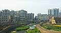
Renhuai (simplified Chinese: 仁怀; traditional Chinese: 仁懷; pinyin: Rénhuái) is a county-level city located in the north of Guizhou province, China, bordering Sichuan province to the west. It is under the administration of the prefecture-level city of Zunyi. The city is served by Zunyi Maotai Airport.
Administrative divisions
Renhuai is divided into 5 subdistricts, 14 towns and 1 ethnic township:[1]
- subdistricts
- Yanjin Subdistrict 盐津街道
- Zhongshu Subdistrict 中枢街道
- Canglong Subdistrict 苍龙街道
- Tanchang Subdistrict 坛厂街道
- Luban Subdistrict 鲁班街道
- towns
- Changgang Town 长岗镇
- Wuma Town 五马镇
- Maoba Town 茅坝镇
- Jiucang Town 九仓镇
- Xitou Town 喜头镇
- Daba Town 大坝镇
- Sanhe Town 三合镇
- Hema Town 合马镇
- Huoshi Town 火石镇
- Xuekong Town 学孔镇
- Longjing Town 龙井镇
- Meijiuhe Town 美酒河镇
- Gaodaping Town 高大坪镇
- Maotai Town 茅台镇
- ethnic township
- Houshan Miao and Bouyei Ethnic Township 后山苗族布依族乡
Climate
| Climate data for Renhuai, elevation 890 m (2,920 ft), (1991–2020 normals, extremes 1981–2010)
|
| Month
|
Jan
|
Feb
|
Mar
|
Apr
|
May
|
Jun
|
Jul
|
Aug
|
Sep
|
Oct
|
Nov
|
Dec
|
Year
|
| Record high °C (°F)
|
23.0
(73.4)
|
30.4
(86.7)
|
33.4
(92.1)
|
34.7
(94.5)
|
37.4
(99.3)
|
35.1
(95.2)
|
36.1
(97.0)
|
38.0
(100.4)
|
38.3
(100.9)
|
33.5
(92.3)
|
28.2
(82.8)
|
23.1
(73.6)
|
38.3
(100.9)
|
| Mean daily maximum °C (°F)
|
7.9
(46.2)
|
11.1
(52.0)
|
16.1
(61.0)
|
21.6
(70.9)
|
25.1
(77.2)
|
27.1
(80.8)
|
30.3
(86.5)
|
30.5
(86.9)
|
26.3
(79.3)
|
19.9
(67.8)
|
15.7
(60.3)
|
9.7
(49.5)
|
20.1
(68.2)
|
| Daily mean °C (°F)
|
5.2
(41.4)
|
7.6
(45.7)
|
11.9
(53.4)
|
16.8
(62.2)
|
20.3
(68.5)
|
22.7
(72.9)
|
25.6
(78.1)
|
25.3
(77.5)
|
21.8
(71.2)
|
16.5
(61.7)
|
12.2
(54.0)
|
6.8
(44.2)
|
16.1
(60.9)
|
| Mean daily minimum °C (°F)
|
3.4
(38.1)
|
5.4
(41.7)
|
9.0
(48.2)
|
13.5
(56.3)
|
16.8
(62.2)
|
19.7
(67.5)
|
22.2
(72.0)
|
21.7
(71.1)
|
18.6
(65.5)
|
14.2
(57.6)
|
9.8
(49.6)
|
4.9
(40.8)
|
13.3
(55.9)
|
| Record low °C (°F)
|
−3.8
(25.2)
|
−2.9
(26.8)
|
−1.5
(29.3)
|
3.7
(38.7)
|
7.8
(46.0)
|
12.8
(55.0)
|
14.3
(57.7)
|
15.1
(59.2)
|
10.9
(51.6)
|
4.8
(40.6)
|
−0.5
(31.1)
|
−3.1
(26.4)
|
−3.8
(25.2)
|
| Average precipitation mm (inches)
|
30.2
(1.19)
|
25.4
(1.00)
|
47.2
(1.86)
|
78.8
(3.10)
|
134.1
(5.28)
|
172.9
(6.81)
|
159.2
(6.27)
|
115.0
(4.53)
|
104.0
(4.09)
|
99.2
(3.91)
|
42.6
(1.68)
|
29.4
(1.16)
|
1,038
(40.88)
|
| Average precipitation days (≥ 0.1 mm)
|
15.9
|
14.0
|
15.4
|
15.8
|
18.3
|
17.6
|
13.2
|
12.8
|
13.1
|
18.0
|
14.1
|
15.1
|
183.3
|
| Average snowy days
|
3.4
|
1.8
|
0.1
|
0
|
0
|
0
|
0
|
0
|
0
|
0
|
0
|
0.7
|
6
|
| Average relative humidity (%)
|
83
|
80
|
77
|
76
|
76
|
80
|
74
|
72
|
75
|
82
|
81
|
83
|
78
|
| Mean monthly sunshine hours
|
26.9
|
40.9
|
71.6
|
99.0
|
110.7
|
98.7
|
179.8
|
178.9
|
121.1
|
62.4
|
59.4
|
38.6
|
1,088
|
| Percent possible sunshine
|
8
|
13
|
19
|
26
|
26
|
24
|
43
|
44
|
33
|
18
|
19
|
12
|
24
|
| Source: China Meteorological Administration[2][3]
|
References
Links to related articles |
|---|
Largest cities in Guizhou Source: China Urban Construction Statistical Yearbook 2018 Urban Population and Urban Temporary Population |
|---|
|
Rank
|
|
Pop.
|
Rank
|
|
Pop. |
|

Guiyang

Zunyi
|
1 |
Guiyang |
2,922,400 |
11 |
Panzhou |
216,000
|
Anshun
Bijie
|
| 2 |
Zunyi |
1,060,000 |
12 |
Qingzhen |
202,600
|
| 3 |
Anshun |
464,900 |
13 |
Chishui |
146,700
|
| 4 |
Bijie |
447,300 |
14 |
Xingren |
137,100
|
| 5 |
Tongren |
414,200 |
15 |
Fuquan |
134,000
|
| 6 |
Kaili |
409,100
|
| 7 |
Liupanshui |
359,700
|
| 8 |
Xingyi |
334,100
|
| 9 |
Duyun |
328,400
|
| 10 |
Renhuai |
250,300
|
|
|


