Share to: share facebook share twitter share wa share telegram print page


Postville, Iowa

Postville, Iowa
Motto: 
Hometown to the World[1][2]
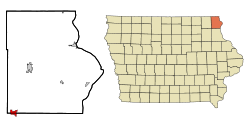
Location of Postville, Iowa
Coordinates: 43°5′6″N 91°34′10″W / 43.08500°N 91.56944°W / 43.08500; -91.56944
CountryUnited States
StateIowa
CountiesAllamakee, Clayton
TownshipPost
SettledJune 1843
IncorporatedMarch 11, 1873
Area
 • Total
2.08 sq mi (5.38 km2)
 • Land2.08 sq mi (5.38 km2)
 • Water0.00 sq mi (0.00 km2)
Elevation
1,181 ft (360 m)
Population
 (2020)
 • Total
2,503
 • Density1,205.10/sq mi (465.29/km2)
Time zoneUTC-6 (Central (CST))
 • Summer (DST)UTC-5 (CDT)
ZIP code
52162
Area code563
FIPS code19-64290
GNIS feature ID0460373
Websitewww.cityofpostville.com

Postville is a village in Allamakee and Clayton counties in the U.S. state of Iowa. It lies near the junction of four counties and at the intersection of U.S. Routes 18 and 52 and Iowa Highway 51, with airport facilities in the neighboring communities of Waukon, Decorah, Monona and Prairie du Chien. The population was 2,503 at the time of the 2020 census, up from 2,273 in 2000.[4] The village is in Allamakee County's southwestern corner and Clayton County's northwestern corner in a quad county, or four-corner region, where four counties intersect. Winneshiek County is just to the west and Fayette County is just to the southwest of Postville.

History

Postville was platted in 1853.[5] The city was named for Joel Post, a pioneer settler.[6]

In 1987, a group of Hasidic Jews started Agriprocessors, a Kosher slaughterhouse, in Postville.[7] After numerous accusations of mistreatment of cattle, pollution, and violations of labor law, the federal government raided the facility in May 2008, resulting in hundreds of arrests of undocumented workers.[8] Agriprocessors filed for bankruptcy on November 5, 2008; SHF Industries bought the plant at auction in July 2009 and it has resumed production under the new name Agri Star.

Geography

According to the United States Census Bureau, the city has an area of 2.11 square miles (5.46 km2), all land.[9]

Climate

Climate data for Postville, Iowa (1991–2020 normals, extremes 1897–present)
Month Jan Feb Mar Apr May Jun Jul Aug Sep Oct Nov Dec Year
Record high °F (°C) 58
(14)
66
(19)
83
(28)
88
(31)
105
(41)
104
(40)
108
(42)
102
(39)
99
(37)
89
(32)
76
(24)
64
(18)
108
(42)
Mean daily maximum °F (°C) 25.7
(−3.5)
29.9
(−1.2)
43.0
(6.1)
57.5
(14.2)
69.4
(20.8)
79.0
(26.1)
82.8
(28.2)
80.8
(27.1)
74.0
(23.3)
60.6
(15.9)
44.7
(7.1)
31.4
(−0.3)
56.6
(13.7)
Daily mean °F (°C) 16.6
(−8.6)
20.2
(−6.6)
32.7
(0.4)
45.8
(7.7)
58.2
(14.6)
68.4
(20.2)
71.9
(22.2)
69.5
(20.8)
61.6
(16.4)
48.8
(9.3)
35.1
(1.7)
22.7
(−5.2)
46.0
(7.8)
Mean daily minimum °F (°C) 7.4
(−13.7)
10.5
(−11.9)
22.4
(−5.3)
34.0
(1.1)
46.9
(8.3)
57.8
(14.3)
60.9
(16.1)
58.2
(14.6)
49.2
(9.6)
37.0
(2.8)
25.5
(−3.6)
14.0
(−10.0)
35.3
(1.8)
Record low °F (°C) −35
(−37)
−29
(−34)
−18
(−28)
6
(−14)
20
(−7)
34
(1)
39
(4)
35
(2)
20
(−7)
−7
(−22)
−12
(−24)
−27
(−33)
−35
(−37)
Average precipitation inches (mm) 1.12
(28)
1.21
(31)
2.09
(53)
4.14
(105)
4.99
(127)
5.88
(149)
4.52
(115)
4.36
(111)
3.96
(101)
3.00
(76)
2.10
(53)
1.57
(40)
38.94
(989)
Average snowfall inches (cm) 12.0
(30)
10.4
(26)
5.0
(13)
1.6
(4.1)
0.0
(0.0)
0.0
(0.0)
0.0
(0.0)
0.0
(0.0)
0.0
(0.0)
0.1
(0.25)
2.7
(6.9)
8.0
(20)
39.8
(101)
Average precipitation days (≥ 0.01 in) 5.8 5.4 6.7 10.1 12.2 11.2 8.8 9.0 8.5 7.7 5.9 6.1 97.4
Average snowy days (≥ 0.1 in) 5.2 4.5 2.6 0.9 0.0 0.0 0.0 0.0 0.0 0.2 1.6 4.5 19.5
Source: NOAA[10][11]

Demographics

Historical populations
YearPop.±%
1880732—    
1890884+20.8%
1900984+11.3%
1910952−3.3%
19201,039+9.1%
19301,060+2.0%
19401,194+12.6%
19501,343+12.5%
19601,554+15.7%
19701,546−0.5%
19801,475−4.6%
19901,472−0.2%
20002,273+54.4%
20102,227−2.0%
20202,503+12.4%
Source:"U.S. Census website". United States Census Bureau. Retrieved March 29, 2020. and Iowa Data Center
Source:
U.S. Decennial Census[12][4]

2020 census

As of the census of 2020,[13] the population was 2,503. The population density was 1,205.7 inhabitants per square mile (465.5/km2). There were 859 housing units at an average density of 413.8 per square mile (159.8/km2). The racial makeup of the city was 52.7% White, 8.7% Black or African American, 2.8% Native American, 0.6% Asian, 26.8% from other races, and 8.3% from two or more races. Ethnically, the population was 43.0% Hispanic or Latino of any race.

2010 census

As of the census[14] of 2010, there were 2,227 people, 744 households, and 497 families residing in the city. The population density was 1,055.5 inhabitants per square mile (407.5/km2). There were 902 housing units at an average density of 427.5 per square mile (165.1/km2). The racial makeup of the city was 77.0% White, 4.4% African American, 0.6% Native American, 1.0% Asian, 0.7% Pacific Islander, 14.3% from other races, and 2.0% from two or more races. Hispanic or Latino of any race were 32.0% of the population.

There were 744 households, of which 40.3% had children under the age of 18 living with them, 47.7% were married couples living together, 14.2% had a female householder with no husband present, 4.8% had a male householder with no wife present, and 33.2% were non-families. 26.9% of all households were made up of individuals, and 12.3% had someone living alone who was 65 years of age or older. The average household size was 2.92 and the average family size was 3.54.

The median age in the city was 30.2 years. 32.7% of residents were under the age of 18; 9.8% were between the ages of 18 and 24; 24.6% were from 25 to 44; 18.4% were from 45 to 64; and 14.5% were 65 years of age or older. The gender makeup of the city was 50.4% male and 49.6% female.

Ethnic groups

In 2017 about one quarter of Postville's population were recent immigrants from Latin America and Somalia; Greg Flakus of Voice of America stated that this was ethnically diverse compared to most Iowa towns, which are almost uniformly non-Hispanic white, even though "Postville is not all that diverse" compared to major American metropolitan areas.[15] The earliest immigrants were from England, Germany, and Scandinavia.[15]

Orthodox Jews established Agriprocessors circa 1987; its founders came from New York City.[15] At its peak, there were about 100 Orthodox Jewish families in Postville. After the 2008 raid, the number declined, and in 2017 there were about 50.[16] Postville has services for Jewish families typically seen in larger communities.[15] It also has a Jewish elementary school and a yeshiva. A Judaic library opened in 2005, but closed after the raid.[16]

The 2008 raid led to the arrests of Hispanics; the resulting lack of labor drew Somalis to Postville from Minnesota and Wisconsin to work in the area kosher factory.[16] Mother Jones said this caused a "cultural shift".[17]

Postville: A Clash of Cultures in Heartland America discusses the arrival of the Orthodox Jews.

Economy

Postville's growth was due to the presence of two large meat processing plants, Agriprocessors and Iowa Turkey Products. The Iowa Turkey Products plant burned in December 2003; it was rebuilt in Marshall, Minnesota.

Agriprocessors, a kosher meat plant, was the largest of its type in the world. As of February 2008 it employed about 900 people and purchased $100 million worth of livestock annually. In May 2008, it was the target of a federal Immigration and Customs Enforcement raid.[18] Subsequently, a criminal complaint was filed against Agriprocessors and its principal for alleged violations of child labor laws.[19] As a result of its legal problems, Agriprocessors became insolvent and was run by a Chapter 11 bankruptcy trustee until SHF Industries bought it at auction in July 2009. It resumed business as Agri Star Meat & Poultry, LLC under the new ownership.

As of 2017, 700 people, more than 30% of the total population, work at Agri Star; about 100 are of Somali origin.[16]

Postville is also the home of a composites factory, Norplex-Micarta, started in 1975.[20] The Norplex factory produces laminated plastics plate, sheet, and profile shapes. As of 2007 it employed between 150 and 200 workers.[21]

Education

Postville Community School District operates public schools.[22] John R. Mott High School is the local high school.

Mesivta of Postville is the area yeshiva.[23]

Notable people

References

  1. ^ "City of Postville, Iowa - Hometown to the World". Cityofpostville.com. Retrieved December 1, 2015.
  2. ^ Jones, Maggie (July 11, 2012). "Postville, Iowa, Is Up for Grabs". Nytimes.com. Retrieved February 8, 2022.
  3. ^ "2020 U.S. Gazetteer Files". United States Census Bureau. Retrieved March 16, 2022.
  4. ^ a b "2020 Census State Redistricting Data". census.gov. United states Census Bureau. Retrieved August 12, 2021.
  5. ^ Alexander, W. E. (1882). History of Winneshiek and Allamakee Counties, Iowa. Western Publishing Company. pp. 398.
  6. ^ Ellery M. Hancock (1913). Past and Present of Allamakee County, Iowa: A Record of Settlement, Organization, Progress and Achievement. S. J. Clarke publishing Company. pp. 477.
  7. ^ "Kosher slaughterhouse owners surrounded by scandal." Los Angeles Times, August 4, 2008
  8. ^ Spencer S. Hsu (May 18, 2008). "Immigration Raid Jars a Small Town". Washington Post.
  9. ^ "US Gazetteer files 2010". United States Census Bureau. Archived from the original on July 2, 2012. Retrieved May 11, 2012.
  10. ^ "NowData – NOAA Online Weather Data". National Oceanic and Atmospheric Administration. Retrieved June 25, 2021.
  11. ^ "Station: Postville, IA". U.S. Climate Normals 2020: U.S. Monthly Climate Normals (1991-2020). National Oceanic and Atmospheric Administration. Retrieved June 25, 2021.
  12. ^ "Census of Population and Housing". Census.gov. Retrieved June 4, 2015.
  13. ^ "2020 Decennial Census: Postville city, Iowa". data.census.gov. U.S. Census Bureau. Retrieved July 1, 2022.
  14. ^ "U.S. Census website". United States Census Bureau. Retrieved May 11, 2012.
  15. ^ a b c d Flakus, Greg (June 2, 2017). "Small Iowa Town Celebrates Its Diversity". Voice of America. Retrieved October 24, 2017.
  16. ^ a b c d Tapper, Josh (February 3, 2016). "Postville, Iowa's Jewish Community Bounces Back After Immigration Raid". Haaretz. Retrieved October 24, 2017.
  17. ^ Michaels, Samantha (August 24, 2017). "A Federal Judge Put Hundreds of Immigrants Behind Bars While Her Husband Invested in Private Prisons". Mother Jones. Retrieved October 24, 2017.
  18. ^ Postville Raid
  19. ^ "Mayor: Feds turned my town 'topsy turvy'". cnn.com. Retrieved December 1, 2015.
  20. ^ "About Norplex-Micarta: history, technology, and capabilities". Norplex-Micarta. Retrieved August 16, 2019.
  21. ^ "CORTERA-NORPLEX OAK INC". Cortera, Inc. Retrieved April 22, 2011.
  22. ^ "Postville Community School District Map" (PDF). Iowa Department of Education. Retrieved April 6, 2020.
  23. ^ Home. Mesivtapostville.org, Retrieved on October 24, 2017.
  24. ^ Wixon, Richard (1997). "Biographical Sketch of William McMinkey". In Weatherly Sharp, Nancy; Sharp, James Roger (eds.). American Legislative Leaders in the Midwest, 1911-1994. Westport, Connecticut: Greenwood Press. p. 171. Retrieved September 12, 2022.
  25. ^ "High School". Postville Community School District. March 3, 2001. Archived from the original on March 3, 2001. Retrieved April 7, 2020. - The link for Mott goes to this page
  26. ^ "Brett Szabo is Awarded Membership Into Postville's Hall of Fame". Postville Community School District. June 20, 2005. Retrieved July 21, 2021.

Books on Postville

  • The interaction of long-time Postville residents with newcomers was the subject of a book about the town, Postville: A Clash of Cultures in Heartland America, by Stephen G. Bloom, a professor at University of Iowa.
  • A more recent book about the community and its experience with diversity before and after the May 2008 federal immigration raid is Postville USA: Surviving Diversity in Small-Town America by Mark Grey, Michele Devlin, and Aaron Goldsmith.
Kembali kehalaman sebelumnya


Index: pl ar de en es fr it arz nl ja pt ceb sv uk vi war zh ru af ast az bg zh-min-nan bn be ca cs cy da et el eo eu fa gl ko hi hr id he ka la lv lt hu mk ms min no nn ce uz kk ro simple sk sl sr sh fi ta tt th tg azb tr ur zh-yue hy my ace als am an hyw ban bjn map-bms ba be-tarask bcl bpy bar bs br cv nv eml hif fo fy ga gd gu hak ha hsb io ig ilo ia ie os is jv kn ht ku ckb ky mrj lb lij li lmo mai mg ml zh-classical mr xmf mzn cdo mn nap new ne frr oc mhr or as pa pnb ps pms nds crh qu sa sah sco sq scn si sd szl su sw tl shn te bug vec vo wa wuu yi yo diq bat-smg zu lad kbd ang smn ab roa-rup frp arc gn av ay bh bi bo bxr cbk-zam co za dag ary se pdc dv dsb myv ext fur gv gag inh ki glk gan guw xal haw rw kbp pam csb kw km kv koi kg gom ks gcr lo lbe ltg lez nia ln jbo lg mt mi tw mwl mdf mnw nqo fj nah na nds-nl nrm nov om pi pag pap pfl pcd krc kaa ksh rm rue sm sat sc trv stq nso sn cu so srn kab roa-tara tet tpi to chr tum tk tyv udm ug vep fiu-vro vls wo xh zea ty ak bm ch ny ee ff got iu ik kl mad cr pih ami pwn pnt dz rmy rn sg st tn ss ti din chy ts kcg ve 
Prefix: a b c d e f g h i j k l m n o p q r s t u v w x y z 0 1 2 3 4 5 6 7 8 9