Share to: share facebook share twitter share wa share telegram print page


Paracatu, Minas Gerais

Paracatu
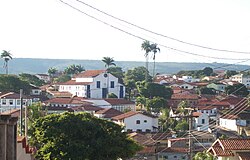
Partial view of Paracatu
Flag of Paracatu
Official seal of Paracatu
Localization of Paracatu in Minas Gerais
Paracatu is located in Brazil
Paracatu
Paracatu
Localization of Paracatu in Brazil
Coordinates: 17°13′18″S 46°52′30″W / 17.22167°S 46.87500°W / -17.22167; -46.87500
Country Brazil
RegionSoutheast
State Minas Gerais
FoundedOctober 20, 1798
Government
 • MayorOlavo Remígio Condé (PSDB)
(2013-2016)
Area
 • Total
8.229588 km2 (3.177462 sq mi)
Elevation
688 m (2,257 ft)
Population
 (2020 [1])
 • Total
93,862
 • Density10.29/km2 (26.7/sq mi)
DemonymParacatuense
Time zoneUTC−3 (BRT)
Postal Code (CEP)
38600-000
Area code+55 38
Websitewww.paracatu.mg.gov.br

Paracatu is a municipality in the state of Minas Gerais in Brazil. The name is of Tupi origin, translated "good river", from "Para" (river) and "katu" (good).

History

The region of Paracatu has been explored by Europeans since the end of the 16th century. In the middle of the 18th century deposits of gold and silver were discovered, and the area was settled. The settlement became the town Vila de Paracatu do Príncipe by royal charter in 1798.[2]

Economy

The economy is centered on gold mining and agriculture.

Mining

In Paracatu, gold has been mined since 1722.[3] The Morro do Ouro (Paracatu) open-pit mine is operated by Rio Paracatu Mineração (RPM), a 100% owned subsidiary of the Canadian company Kinross Gold Corporation. The gold content of the ore is comparatively low, about 0.41 gram of gold for every ton of ore extracted. Annual production is about 15 tonnes of gold and 5 tonnes of silver.[4][5]

Kinross Gold owns the open-pit Paracatu gold mine operated as Kinross Brasil Mineração S.A. that includes two process plants, two tailings facilities, as well as accompanying infrastructure.[6] This mine is the region's largest employer.[7] In 2015, Paracatu produced 477,662 gold equivalent ounces.[8]

Agriculture

Cattle raising is the main agricultural activity with 231,000 head (1996). The main breeds are: Zebu (Gir, Indu-Brasil, Guzerá and Nelore), Girolanda, Frisian and Brown-Swiss. There is also large production of soybeans, corn, rice, beans, and also some coffee. Paracatu is the commercial center for an area one third the size of Portugal. In 2006 there were 6 banking branches: Banco do Brasil, Itaú, Bradesco, Banco Mercantil, Banco Bamerindus, and Caixa Econômica Federal.[9] The GDP was R$754,090,000 (2005).[10]

In 1978 the municipality began to receive investments from the Brazilian and the Japanese government to develop the cerrado soils, through the PRODECER-Programa de Cooperação Nipo-Brasileiro para o Desenvolviemnto do Cerrado.

Because of new technologies used to develop the cerrado, agriculture in Paracatu became efficient and profitable in many properties. Nowadays, the cultivated area in the municipality surpasses 1000 square kilometres, with 300 square kilometres irrigated by central pivot sprinklers. This number has raised Paracatu to the position of greatest continuous area irrigated by center pivot irrigation in South America, using 318 center pivot sprinklers.[11]

Agricultural data

In 2006 there were 995 rural producers with total agricultural land of 389,095 ha. Of the total 85,000 ha. were planted, 180,000 ha. were in natural pasture, and 113,000 were in forest or woodland. Around 4,500 persons were employed in agriculture. There were 768 tractors. The planted area of some of the main crops in hectares was:

  • Corn: 12,000
  • Soybeans: 30,000
  • Sorghum: 2,000
  • Rice: 2,670
  • Coffee: 1,050
  • Cotton: 3,000
  • Sugarcane: 1,600
  • Beans: 9,100
  • Watermelon: 1,050 [10]

Quilombola population

Many quilombola (descendants of escaped slaves) communities live in and near Paracatu, often in poverty.[12][13]

Health and education

In 2005 there were 29 health establishments, 19 of which were public and 10 of which were private. There was 1 hospital with 139 beds.[10] The score on the Municipal Human Development Index was 0.760. This ranked Paracatu 207 out of 853 municipalities in the state, with Poços de Caldas in first place with 0.841 and Setubinha in last place with 0.568.[14]

Paracatu has 4 faculties with undergraduation and graduation courses: Faculdade Tecsoma, FINOM – Faculdade do Noroeste de Minas, Faculdade Unimontes, and Faculdade Atenas.[15]

Transportation

The city is served by Pedro Rabelo de Souza Airport.

Climate

Paracatu has a tropical savanna climate (Köppen: Aw) with a hot rainy season and warm dry season.

Climate data for Paracatu (1991–2020)
Month Jan Feb Mar Apr May Jun Jul Aug Sep Oct Nov Dec Year
Mean daily maximum °C (°F) 30.5
(86.9)
30.8
(87.4)
30.3
(86.5)
30.0
(86.0)
28.7
(83.7)
28.0
(82.4)
28.3
(82.9)
30.1
(86.2)
32.0
(89.6)
32.5
(90.5)
30.5
(86.9)
30.0
(86.0)
30.1
(86.2)
Daily mean °C (°F) 24.6
(76.3)
24.8
(76.6)
24.4
(75.9)
23.9
(75.0)
22.0
(71.6)
20.7
(69.3)
20.7
(69.3)
22.4
(72.3)
24.6
(76.3)
25.7
(78.3)
24.5
(76.1)
24.3
(75.7)
23.6
(74.5)
Mean daily minimum °C (°F) 20.3
(68.5)
20.3
(68.5)
20.1
(68.2)
19.2
(66.6)
16.7
(62.1)
15.1
(59.2)
14.7
(58.5)
15.8
(60.4)
18.5
(65.3)
20.2
(68.4)
20.1
(68.2)
20.2
(68.4)
18.4
(65.1)
Average precipitation mm (inches) 258.0
(10.16)
204.4
(8.05)
207.8
(8.18)
73.8
(2.91)
24.1
(0.95)
5.6
(0.22)
0.9
(0.04)
8.9
(0.35)
28.8
(1.13)
80.3
(3.16)
212.2
(8.35)
313.4
(12.34)
1,418.2
(55.83)
Average precipitation days (≥ 1.0 mm) 15.1 11.7 12.3 6.3 2.3 0.6 0.3 0.8 3.2 6.9 14.1 17.4 91.0
Average relative humidity (%) 76.9 75.8 78.2 75.0 72.6 69.1 63.4 55.9 54.7 60.3 74.3 78.7 69.6
Average dew point °C (°F) 20.6
(69.1)
20.7
(69.3)
20.9
(69.6)
19.8
(67.6)
17.6
(63.7)
15.8
(60.4)
14.4
(57.9)
14.0
(57.2)
15.4
(59.7)
17.6
(63.7)
19.9
(67.8)
20.6
(69.1)
18.1
(64.6)
Mean monthly sunshine hours 192.6 187.5 203.0 230.2 247.4 258.8 270.9 277.0 246.5 219.4 163.9 165.8 2,663
Source: NOAA[16]

See also

References

  1. ^ IBGE 2020
  2. ^ IBGE, history
  3. ^ www.theguardian.com: Canadian Mininig commany spied on opponents and activists in Brazil. (13-May-2015)
  4. ^ "Kinross: Operation: Paracatu Brazil". Kinross Gold Corporation. Archived from the original on September 9, 2010. Retrieved July 23, 2010.
  5. ^ Henderson, R. D. (July 31, 2006). "Paracatu Mine Technical Report" (PDF). Kinross Gold Corporation. Archived from the original (PDF) on October 11, 2010. Retrieved July 23, 2010.
  6. ^ Canadian and American Mines Handbook. Business Information Group. 2005. ISBN 978-0-919336-63-6.
  7. ^ "Metso to supply grinding equipment to Kinross Gold's Paracatu in Brazil". International Mining. International Mining. Retrieved 23 September 2016.
  8. ^ See page MDA 20 of 2015 Kinross Gold Annual Report http://s2.q4cdn.com/496390694/files/doc_financials/annual/2016/2015-Kinross-Gold-Annual-Report.pdf
  9. ^ "Agências bancárias". Prefeitura Municipal Paracatu. Retrieved 2010-07-23.
  10. ^ a b c "IBGE". IBGE. Retrieved 2010-07-23.
  11. ^ "Prefeitura Municipal de Paracatu". Paracatu.mg.gov.br. Retrieved 2010-07-23.
  12. ^ Colitt, Raymond (July 4, 2007). "Descendants of slaves still suffer in Brazil". Reuters. Archived from the original on August 16, 2010. Retrieved July 23, 2010.
  13. ^ Pyl, Bianca (May 3, 2010). "Incra não cumpre meta e titula 2 territórios quilombolas em 2009". Repórter Brasil (in Portuguese). Retrieved July 23, 2010.
  14. ^ "Frigoletto". Frigoletto. Archived from the original on 2011-07-06. Retrieved 2010-07-23.
  15. ^ "Cidades On Line – Paracatu". Paracatuonline.com.br. Retrieved 2010-07-23.
  16. ^ "World Meteorological Organization Climate Normals for 1991-2020 — Paracatu". National Oceanic and Atmospheric Administration. Retrieved January 31, 2024.
Kembali kehalaman sebelumnya


Index: pl ar de en es fr it arz nl ja pt ceb sv uk vi war zh ru af ast az bg zh-min-nan bn be ca cs cy da et el eo eu fa gl ko hi hr id he ka la lv lt hu mk ms min no nn ce uz kk ro simple sk sl sr sh fi ta tt th tg azb tr ur zh-yue hy my ace als am an hyw ban bjn map-bms ba be-tarask bcl bpy bar bs br cv nv eml hif fo fy ga gd gu hak ha hsb io ig ilo ia ie os is jv kn ht ku ckb ky mrj lb lij li lmo mai mg ml zh-classical mr xmf mzn cdo mn nap new ne frr oc mhr or as pa pnb ps pms nds crh qu sa sah sco sq scn si sd szl su sw tl shn te bug vec vo wa wuu yi yo diq bat-smg zu lad kbd ang smn ab roa-rup frp arc gn av ay bh bi bo bxr cbk-zam co za dag ary se pdc dv dsb myv ext fur gv gag inh ki glk gan guw xal haw rw kbp pam csb kw km kv koi kg gom ks gcr lo lbe ltg lez nia ln jbo lg mt mi tw mwl mdf mnw nqo fj nah na nds-nl nrm nov om pi pag pap pfl pcd krc kaa ksh rm rue sm sat sc trv stq nso sn cu so srn kab roa-tara tet tpi to chr tum tk tyv udm ug vep fiu-vro vls wo xh zea ty ak bm ch ny ee ff got iu ik kl mad cr pih ami pwn pnt dz rmy rn sg st tn ss ti din chy ts kcg ve 
Prefix: a b c d e f g h i j k l m n o p q r s t u v w x y z 0 1 2 3 4 5 6 7 8 9