Share to: share facebook share twitter share wa share telegram print page


Mount Meron

Mount Meron
Har MerónJábal al-Jármaq
הַר מֵירוֹן‎ • جبل الجرمق
Northern slopes of Mount Meron
Highest point
Elevation1,204 m (3,950 ft)
Coordinates32°59′52″N 35°24′49″E / 32.99778°N 35.41361°E / 32.99778; 35.41361
Geography
Mount Meron is located in Israel
Mount Meron
Mount Meron
Mount Meron is located in Northeast Israel
Mount Meron
Mount Meron
Mount Meron (Northeast Israel)

Mount Meron (Hebrew: הַר מֵירוֹן, Har Meron; Arabic: جبل الجرمق, Jabal al-Jarmaq)[1] is a mountain in the Upper Galilee region of Israel. It has special significance in Jewish religious tradition and parts of it have been declared a nature reserve. At 1,204 metres (3,950 ft) above sea level, Mount Meron is the highest peak in Israel within the Green Line,[2] though many peaks in the Golan Heights, which was annexed by Israel in 1981, are higher, with the highest in Israeli-occupied territory being Mitze Hashlagim at an altitude of 2,236 m (7,336 ft), nearby Mount Hermon.[3]

Mount Meron nature reserve

In 1965, an 84,000-dunam nature reserve was declared. An additional 1,199 dunams were declared part of the reserve in 2005.[4] It is the highest reserve in Israel, at an altitude of 1,204 meters above sea level, and the largest reserve in the north of the country.[5]

Religious significance
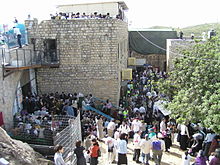
Tomb of Shimon bar Yochai

The village of Meron and the tomb of Rabbi Shimon bar Yochai are on Mount Meron.[6] Leading up to the anniversary of his death on Lag BaOmer, thousands of people[7] camp out along the slopes near the tomb, and on Lag B'Omer itself, hundreds of thousands make pilgrimages to celebrate the occasion.[8]

Hiking paths

In Mount Meron Nature Reserve, there are some 45 hiking trails and routes for visitors to explore.[9] At Mount Meron’s peak, there is a circular walking path, from which visitors can observe panoramic views and see rare vegetation.[10] The Peak Trail surrounds the summit of Mount Meron and includes three lookout points: the Tzfat viewpoint (overlooking the city of Tzfat and the eastern Upper Galilee), the Lebanon viewpoint (looking north into Lebanese territory) and the mountain viewpoint (overlooking the Druze village of Beit Jann, on Mount Peki'in and the western Galilee).[11]

In art

Mount Meron is a subject in Israeli and Jewish art. Gideon Ofrat described how artists such as Isaac Frenkel, Moshe Castel and others would paint scenes described as fiery or serene, with a particular focus on sunsets over Mount Meron as seen from afar in the city of Safed where an artists' quarter sat.[12]

Climate

Snowfall on Mount Meron

Mount Meron has a Mediterranean climate (Köppen climate classification: Csa) with hot and dry summers and cool, wet and occasionally snowy winters. It snows briefly on Mount Meron a few times during the winter. There are 22 days a year with a temperature of 32 °C or higher and 28 days below freezing. Mount Meron has a relatively cool climate with significant precipitation;[13] and has the second highest precipitation in Israel after Mount Hermon.

Note: the chart is an average of 5 years so the record highs and lows may not be fully accurate.

Climate data for Mount Meron (2002–2007)
Month Jan Feb Mar Apr May Jun Jul Aug Sep Oct Nov Dec Year
Record high °C (°F) 17
(63)
22
(72)
18
(64)
26
(79)
32
(90)
32
(90)
33
(91)
36
(97)
33
(91)
28
(82)
26
(79)
20
(68)
36
(97)
Mean daily maximum °C (°F) 8
(46)
9
(48)
11
(52)
18
(64)
23
(73)
27
(81)
29
(84)
30
(86)
27
(81)
26
(79)
20
(68)
12
(54)
20
(68)
Daily mean °C (°F) 6
(43)
6
(43)
7
(45)
13
(55)
18
(64)
21
(70)
23
(73)
24
(75)
21
(70)
20
(68)
16
(61)
9
(48)
15
(59)
Mean daily minimum °C (°F) 4
(39)
3
(37)
4
(39)
8
(46)
13
(55)
15
(59)
17
(63)
18
(64)
16
(61)
15
(59)
12
(54)
6
(43)
11
(52)
Record low °C (°F) −2
(28)
−8
(18)
3
(37)
7
(45)
11
(52)
15
(59)
13
(55)
13
(55)
11
(52)
5
(41)
−8
(18)
Average precipitation mm (inches) 70
(2.8)
190
(7.5)
270
(10.6)
60
(2.4)
80
(3.1)
180
(7.1)
20
(0.8)
240
(9.4)
1,150
(45.3)
Average precipitation days 5 10 8 4 5 10 1 10 56
Average relative humidity (%) 75 72 68 55 45 45 46 49 52 50 56 72 57
Source: "Climate Information for Har Meron, Israel". Weather Base.

Incidents

On May 17, 1911, the collapse of an eight-meter high roof caused 40 wounded and seven fatalities.[14] As the nearby hospital was closed, people from the surrounding area donated bedsheets and equipment to assist the wounded.[15]

At about 12:50 a.m. on April 30, 2021, hundreds of Israelis were trampled as they were leaving the mountain, having attended a Lag BaOmer celebration that drew an estimated 100,000 people in spite of a 10,000-people limit imposed due to the COVID-19 pandemic. At least 45 people died in the disaster, with hundreds injured.[16]

References

  1. ^ "Encyclopædia Britannica: Mount Meron". Retrieved 2008-11-24.
  2. ^ Federal Research Division (2004). Israel A Country Study (Paperback ed.). Kessinger Publishing, LLC. p. 8. ISBN 141912689X.
  3. ^ "Mitze Hashlagim - Peakbagger.com". www.peakbagger.com. Retrieved 2024-09-10.
  4. ^ "List of National Parks and Nature Reserves" (PDF) (in Hebrew). Israel Nature and Parks Authority. Archived from the original (PDF) on 2009-10-07. Retrieved 2010-09-27.
  5. ^ "Mount Meron reserve" (in Hebrew). Israel Nature and Parks Authority. Archived from the original on 2011-09-28. Retrieved 2010-09-27.
  6. ^ Benayahu, Meir. "Devotion Practices of the Kabbalists of Safed in Meron". Sefunot: Studies and Sources on the History of the Jewish Communities in the East / ספונות: מחקרים ומקורות לתולדות קהילות ישראל במזרח: 5–29. JSTOR 23415184.
  7. ^ Liphshitz, Cnaan (April 30, 2021). "What is Israel's Mount Meron and why were so many Orthodox Jews gathered there for the Lag b'Omer holiday?". Jewish Telegraphic Agency. Retrieved 2 March 2024.
  8. ^ Gelis, Jacob (1968). The Customs of the Land of Israel (מנהגי ארץ-ישראל). Jerusalem: Mossad Harav Kook. p. 139 (yod-gimel). OCLC 873519965.
  9. ^ "Best Trails in Har Meron Nature Reserve". AllTrails. AllTrails, LLC. Retrieved 2 March 2024.
  10. ^ "Mount Meron Nature Reserve". Nature and Parks Authority. Retrieved 2 March 2024.
  11. ^ "תצפיות נוף". Nature and Parks Authority. Retrieved 2 March 2024.
  12. ^ Ofrat, Gideon. The Art and Artists of Safed (in Hebrew). pp. 89–90.
  13. ^ "צומח". Nature and Parks Authority. Retrieved 2 March 2024.
  14. ^ גלילי, זאב (May 9, 2017). "ל"ג בעומר 1911 – האסון שזעזע את ארץ ישראל".
  15. ^ "לג בעומר, מירון 1911: הילולה שהפכה ליללה". www.news1.co.il.
  16. ^ "44 crushed to death, over 150 hurt in stampede at mass Lag B'Omer event in Meron". Times of Israel. 30 April 2021. Retrieved 2021-04-30.
Kembali kehalaman sebelumnya


Index: pl ar de en es fr it arz nl ja pt ceb sv uk vi war zh ru af ast az bg zh-min-nan bn be ca cs cy da et el eo eu fa gl ko hi hr id he ka la lv lt hu mk ms min no nn ce uz kk ro simple sk sl sr sh fi ta tt th tg azb tr ur zh-yue hy my ace als am an hyw ban bjn map-bms ba be-tarask bcl bpy bar bs br cv nv eml hif fo fy ga gd gu hak ha hsb io ig ilo ia ie os is jv kn ht ku ckb ky mrj lb lij li lmo mai mg ml zh-classical mr xmf mzn cdo mn nap new ne frr oc mhr or as pa pnb ps pms nds crh qu sa sah sco sq scn si sd szl su sw tl shn te bug vec vo wa wuu yi yo diq bat-smg zu lad kbd ang smn ab roa-rup frp arc gn av ay bh bi bo bxr cbk-zam co za dag ary se pdc dv dsb myv ext fur gv gag inh ki glk gan guw xal haw rw kbp pam csb kw km kv koi kg gom ks gcr lo lbe ltg lez nia ln jbo lg mt mi tw mwl mdf mnw nqo fj nah na nds-nl nrm nov om pi pag pap pfl pcd krc kaa ksh rm rue sm sat sc trv stq nso sn cu so srn kab roa-tara tet tpi to chr tum tk tyv udm ug vep fiu-vro vls wo xh zea ty ak bm ch ny ee ff got iu ik kl mad cr pih ami pwn pnt dz rmy rn sg st tn ss ti din chy ts kcg ve 
Prefix: a b c d e f g h i j k l m n o p q r s t u v w x y z 0 1 2 3 4 5 6 7 8 9