Share to: share facebook share twitter share wa share telegram print page


Kisoro

Kisoro
Gisoro
Kisoro is located in Uganda
Kisoro
Kisoro
Location in Uganda
Coordinates: 01°17′06″S 29°41′06″E / 1.28500°S 29.68500°E / -1.28500; 29.68500
Country Uganda
RegionWestern Region of Uganda
Sub-regionKigezi sub-region
DistrictKisoro District
Government
 • Chairman LC5Bizimana Abel[citation needed]
Elevation
6,329 ft (1,929 m)
Population
 (2014 Census)
 • Total
17,561[1]
Time zoneEast Africa Time
ClimateCfb
Websitehttps://kisoro.go.ug/

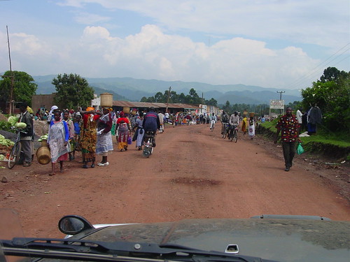
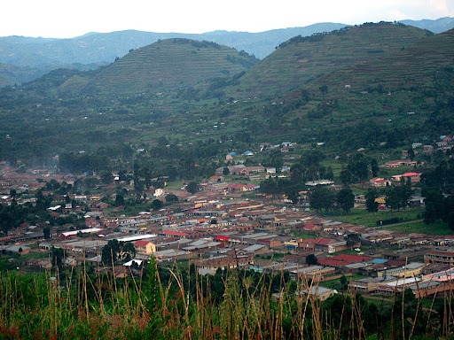
Kisoro is a town in the Western Region of Uganda. It is the chief town of Kisoro District and the site of the district headquarters.

Location

Kisoro is approximately 76 kilometres (47 mi) west of Kabale, the largest city in the Kigezi sub-region.[2] This is approximately 484 kilometres (301 mi), by road, southwest of Kampala, the capital of Uganda and the country's largest city.[3] Kisoro is east of Rumangabo and the Virunga Mountains in the Democratic Republic of the Congo (DRC). The geographical coordinates of Kisoro are 1°17'06.0"S, 29°41'06.0"E (Latitude:-1.2850; Longitude:29.6850).[4] Kisoro Town Council sits at an average elevation of 1,929 metres (6,329 ft), above mean sea level.[5]

Overview

Kisoro is located under the peaks of the Mufumbiro Mountains, which are part of the Virunga Mountains and home to rare mountain gorillas. The area boasts of mountain scenery, Lake Mutanda, colorful markets, and volcano trekking. It is the nearest town to the Mgahinga Gorilla National Park and is an access town for those traveling to Rwanda or the DRC for gorilla tracking in the Volcanoes National Park or the Virunga National Park.[6]

Population

The 2002 national census estimated the population of Kisoro at 11,330. The Uganda Bureau of Statistics (UBOS) estimated the population at 12,700 in 2010. In 2011, UBOS estimated the mid-year population at 12,900.[7] In 2014, the national population census estimated the population at 17,561.[1]

Points of interest

The following additional points of interest are located within the town limits or near its edges:

Photos

See also

References

  1. ^ a b UBOS (29 November 2014). "The Population of The Regions of the Republic of Uganda And All Cities And Towns of More Than 15,000 Inhabitants". Citypopulation.de Quoting Uganda Bureau of Statistics (UBOS). Retrieved 28 February 2015.
  2. ^ "Road Distance Between Kabale, Uganda And Kisoro, Uganda" (Map). Google Maps. Retrieved 22 August 2021.
  3. ^ "Road Distance Between Kampala, Uganda And Kisoro, Uganda With Map" (Map). Google Maps. Retrieved 22 August 2021.
  4. ^ "Location of Kisoro, Uganda" (Map). Google Maps. Retrieved 22 August 2021.
  5. ^ Elevation Maplogs (22 August 2021). "Worldwide Elevation Finder". Elevation.maplogs.com. Retrieved 22 August 2021.
  6. ^ UTP. "Overview of Kisoro Town, Uganda". Uganda Travel Planner (UTP). Archived from the original on 28 May 2014. Retrieved 7 June 2014.
  7. ^ UBOS. "Estimated Population of Kisoro In 2002, 2010 And 2011" (PDF). Uganda Bureau of Statistics (UBOS). Archived from the original (PDF) on 7 July 2014. Retrieved 7 June 2014.

01°17′06″S 29°41′06″E / 1.28500°S 29.68500°E / -1.28500; 29.68500

Kembali kehalaman sebelumnya


Index: pl ar de en es fr it arz nl ja pt ceb sv uk vi war zh ru af ast az bg zh-min-nan bn be ca cs cy da et el eo eu fa gl ko hi hr id he ka la lv lt hu mk ms min no nn ce uz kk ro simple sk sl sr sh fi ta tt th tg azb tr ur zh-yue hy my ace als am an hyw ban bjn map-bms ba be-tarask bcl bpy bar bs br cv nv eml hif fo fy ga gd gu hak ha hsb io ig ilo ia ie os is jv kn ht ku ckb ky mrj lb lij li lmo mai mg ml zh-classical mr xmf mzn cdo mn nap new ne frr oc mhr or as pa pnb ps pms nds crh qu sa sah sco sq scn si sd szl su sw tl shn te bug vec vo wa wuu yi yo diq bat-smg zu lad kbd ang smn ab roa-rup frp arc gn av ay bh bi bo bxr cbk-zam co za dag ary se pdc dv dsb myv ext fur gv gag inh ki glk gan guw xal haw rw kbp pam csb kw km kv koi kg gom ks gcr lo lbe ltg lez nia ln jbo lg mt mi tw mwl mdf mnw nqo fj nah na nds-nl nrm nov om pi pag pap pfl pcd krc kaa ksh rm rue sm sat sc trv stq nso sn cu so srn kab roa-tara tet tpi to chr tum tk tyv udm ug vep fiu-vro vls wo xh zea ty ak bm ch ny ee ff got iu ik kl mad cr pih ami pwn pnt dz rmy rn sg st tn ss ti din chy ts kcg ve 
Prefix: a b c d e f g h i j k l m n o p q r s t u v w x y z 0 1 2 3 4 5 6 7 8 9