Share to: share facebook share twitter share wa share telegram print page


Hauts-de-France

Hauts-de-France
Heuts-d'Franche (Picard)
Upper France
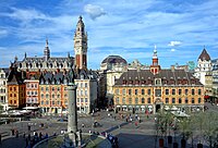
Grand Place in Lille
Flag of Hauts-de-France
Coat of arms of Hauts-de-France
Coordinates: 49°55′14″N 2°42′11″E / 49.9206°N 2.7030°E / 49.9206; 2.7030
Country France
PrefectureLille
Departments
5
Government
 • President of the Regional CouncilXavier Bertrand (LR)
Area
 • Total
31,813 km2 (12,283 sq mi)
 • Rank9th
Population
 (2022)[1]
 • Total
5,998,916
 • Density190/km2 (490/sq mi)
GDP
 • Total€185.472 billion (2022)
 • Per capita€30,900 (2022)
Time zoneUTC+01:00 (CET)
 • Summer (DST)UTC+02:00 (CEST)
ISO 3166 codeFR-HDF
NUTS RegionFRE
Websitewww.hautsdefrance.fr Edit this at Wikidata

Hauts-de-France (French: [o d(ə) fʁɑ̃s] ; Picard: Heuts d'Franche; lit.'Heights of France'), also referred to in English as Upper France,[3] is the northernmost region of France, created by the territorial reform of French regions in 2014, from a merger of Nord-Pas-de-Calais and Picardy. Its prefecture is Lille. The new region came into existence on 1 January 2016, after regional elections in December 2015.[4] The Conseil d'État approved Hauts-de-France as the name of the region on 28 September 2016, effective the following 30 September.[5][6]

With 6,009,976 inhabitants as of 1 January 2015 and a population density of 189 inhabitants per km2, it is the third most populous region in France and the second-most densely populated in metropolitan France after its southern neighbour Île-de-France. It is bordered by Belgium to the north and by the United Kingdom to the northwest through the Channel Tunnel, a railway tunnel crossing the English Channel. The region is a blend mixture of French and (southern-) Dutch cultures.

Toponymy

The region's interim name Nord-Pas-de-Calais-Picardie was a hyphenated placename, created by hyphenating the merged regions' names—Nord-Pas-de-Calais and Picardie—in alphabetical order.[7]

On 14 March 2016, well ahead of the 1 July deadline, the regional council decided on Hauts-de-France as the region's permanent name.[5][7] The provisional name of the region was retired on 30 September 2016, when the new name of the region, Hauts-de-France, took effect.[6]

Geography

The region covers an area of more than 31,813 km2 (12,283 sq mi). It borders Belgium (Flanders and Wallonia) to the northeast, the North Sea to the north, the English Channel to the west, as well as the French regions of Grand Est to the east-southeast, Île-de-France to the south, and Normandy to the west-southwest. It is connected to the United Kingdom (England) via the Channel Tunnel.
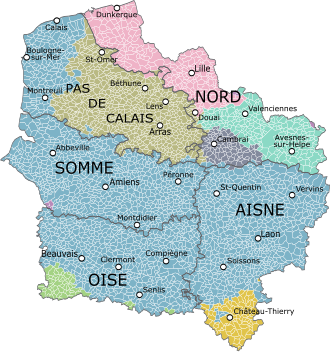
Map of the new region with its five départements, coloured according to the historical provinces as they existed until 1790.
  Artois

Departments

Hauts-de-France comprises five departments: Aisne, Nord, Oise, Pas-de-Calais, and Somme.

Major communities

  1. Lille (227,560; region prefecture; surrounding area is home to over 1.5 million inhabitants)
  2. Amiens (133,448)
  3. Roubaix (94,713)
  4. Tourcoing (91,923)
  5. Dunkirk (90,995)
  6. Calais (72,589)
  7. Villeneuve-d'Ascq (62,308)
  8. Saint-Quentin (55,978)
  9. Beauvais (54,289)
  10. Valenciennes (42,691)

Economy

The gross domestic product (GDP) of the region was 161.7 billion euros in 2018, accounting for 6.9% of French economic output. GDP per capita adjusted for purchasing power was 24,200 euros or 80% of the EU27 average in the same year. The GDP per employee was 101% of the EU average.[8]

Linen weaving

The region was a pivotal centre of mulquinerie.

See also

References

  1. ^ "Populations de référence 2022" (in French). The National Institute of Statistics and Economic Studies. 19 December 2024.
  2. ^ "EU regions by GDP, Eurostat". Retrieved 18 September 2023.
  3. ^ "The North: Upper France". francerevisited.com.
  4. ^ "La carte à 13 régions définitivement adoptée" [The 13-region map finally adopted]. Le Monde (in French). Agence France-Presse. 17 December 2014. Retrieved 13 January 2015.
  5. ^ a b "La Région a voté et s'appelle désormais Hauts-de-France" [The region has voted and is now called Hauts-de-France]. La Voix du Nord (in French). Lille. 15 March 2016. Retrieved 15 March 2016.
  6. ^ a b Décret n° 2016-1265 du 28 septembre 2016 portant fixation du nom et du chef-lieu de la région Hauts-de-France (in French)
  7. ^ a b Loi n° 2015–29 du 16 janvier 2015 relative à la délimitation des régions, aux élections régionales et départementales et modifiant le calendrier électoral (in French)
  8. ^ "Regional GDP per capita ranged from 30% to 263% of the EU average in 2018". Eurostat.
Kembali kehalaman sebelumnya


Index: pl ar de en es fr it arz nl ja pt ceb sv uk vi war zh ru af ast az bg zh-min-nan bn be ca cs cy da et el eo eu fa gl ko hi hr id he ka la lv lt hu mk ms min no nn ce uz kk ro simple sk sl sr sh fi ta tt th tg azb tr ur zh-yue hy my ace als am an hyw ban bjn map-bms ba be-tarask bcl bpy bar bs br cv nv eml hif fo fy ga gd gu hak ha hsb io ig ilo ia ie os is jv kn ht ku ckb ky mrj lb lij li lmo mai mg ml zh-classical mr xmf mzn cdo mn nap new ne frr oc mhr or as pa pnb ps pms nds crh qu sa sah sco sq scn si sd szl su sw tl shn te bug vec vo wa wuu yi yo diq bat-smg zu lad kbd ang smn ab roa-rup frp arc gn av ay bh bi bo bxr cbk-zam co za dag ary se pdc dv dsb myv ext fur gv gag inh ki glk gan guw xal haw rw kbp pam csb kw km kv koi kg gom ks gcr lo lbe ltg lez nia ln jbo lg mt mi tw mwl mdf mnw nqo fj nah na nds-nl nrm nov om pi pag pap pfl pcd krc kaa ksh rm rue sm sat sc trv stq nso sn cu so srn kab roa-tara tet tpi to chr tum tk tyv udm ug vep fiu-vro vls wo xh zea ty ak bm ch ny ee ff got iu ik kl mad cr pih ami pwn pnt dz rmy rn sg st tn ss ti din chy ts kcg ve 
Prefix: a b c d e f g h i j k l m n o p q r s t u v w x y z 0 1 2 3 4 5 6 7 8 9