Share to: share facebook share twitter share wa share telegram print page


Friendsville, Pennsylvania

Friendsville, Pennsylvania
St. Francis Xavier Church
Location of Friendsville in Susquehanna County, Pennsylvania.
Friendsville is located in Pennsylvania
Friendsville
Friendsville
Friendsville is located in the United States
Friendsville
Friendsville
Coordinates: 41°55′05″N 76°02′49″W / 41.91806°N 76.04694°W / 41.91806; -76.04694
CountryUnited States
StatePennsylvania
CountySusquehanna
Settled1819
Incorporated1847
Area
 • Total
1.50 sq mi (3.87 km2)
 • Land1.50 sq mi (3.87 km2)
 • Water0.00 sq mi (0.00 km2)
Population
 • Total
101
 • Density67.56/sq mi (26.09/km2)
Time zoneUTC-5 (Eastern (EST))
 • Summer (DST)UTC-4 (EDT)
Zip code
18818
Area code570
FIPS code42-27968

Friendsville is a borough in Susquehanna County, Pennsylvania, United States. The population was 100 at the 2020 census.[3]

History

Friendsville was founded in 1819, and named for the fact a large share of the first settlers were Quakers.[4]

Geography

Friendsville is located at 41°55′5″N 76°2′49″W / 41.91806°N 76.04694°W / 41.91806; -76.04694 (41.917987, -76.046952).[5]

According to the United States Census Bureau, the borough has a total area of 1.5 square miles (3.9 km2), all land.

Demographics

Historical population
CensusPop.Note
1850185
18602029.2%
187022310.4%
1880176−21.1%
1890139−21.0%
1900110−20.9%
1910103−6.4%
192074−28.2%
1930740.0%
1940762.7%
195065−14.5%
196060−7.7%
19707728.3%
198072−6.5%
199010241.7%
200091−10.8%
201011122.0%
2020100−9.9%
2021 (est.)100[3]0.0%
Sources:[6][7][8][2]

2010 census

At the 2010 census there were 111 people, 44 households, and 29 families living in the borough. The population density was 74 people per square mile (29 people/km2). There were 54 housing units at an average density of 36 per square mile (14/km2). The racial makeup of the borough was 91.9% White, 6.3% Black, and 1.8% Native American.[9] Of the 44 households 31.8% had children under the age of 18 living with them, 52.3% were married couples living together, 11.4% had a female householder with no husband present, and 34.1% were non-families. 22.7% of households were one person and 11.4% were one person aged 65 or older. The average household size was 2.52 and the average family size was 2.97.

The age distribution was 27.9% under the age of 18, 55% from 18 to 64, and 17.1% 65 or older. The median age was 42.5 years.

The median household income was $35,625 and the median family income was $51,250. Males had a median income of $29,464 versus $37,917 for females. The per capita income for the borough was $15,996. There were 15.6% of families and 9.6% of the population living below the poverty line, including 7.9% of under 18 and none of those over 65.

2000 census

At the 2000 census there were 91 people, 38 households, and 25 families living in the borough. The population density was 62.0 people per square mile (23.9 people/km2). There were 45 housing units at an average density of 30.7 per square mile (11.9/km2). The racial makeup of the borough was 100.00% White.[7] Of the 38 households 26.3% had children under the age of 18 living with them, 55.3% were married couples living together, 7.9% had a female householder with no husband present, and 34.2% were non-families. 23.7% of households were one person and 5.3% were one person aged 65 or older. The average household size was 2.39 and the average family size was 2.88.

The age distribution was 23.1% under the age of 18, 6.6% from 18 to 24, 26.4% from 25 to 44, 31.9% from 45 to 64, and 12.1% 65 or older. The median age was 42 years. For every 100 females there were 106.8 males. For every 100 females age 18 and over, there were 94.4 males.

The median household income was $53,125 and the median family income was $53,750. Males had a median income of $31,250 versus $24,375 for females. The per capita income for the borough was $18,502. There were 9.4% of families and 6.8% of the population living below the poverty line, including 9.4% of under eighteens and none of those over 64.

References
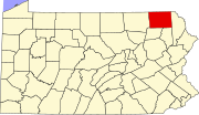
  1. ^ "ArcGIS REST Services Directory". United States Census Bureau. Retrieved October 12, 2022.
  2. ^ a b "Census Population API". United States Census Bureau. Retrieved October 12, 2022.
  3. ^ a b "City and Town Population Totals: 2020—2021". Census.gov. US Census Bureau. Retrieved August 5, 2022.
  4. ^ Espenshade, Abraham Howry (1925). Pennsylvania Place Names. Evangelical Press. p. 310. ISBN 978-0-8063-0416-8.
  5. ^ "US Gazetteer files: 2010, 2000, and 1990". United States Census Bureau. February 12, 2011. Retrieved April 23, 2011.
  6. ^ "Census of Population and Housing". U.S. Census Bureau. Retrieved December 11, 2013.
  7. ^ a b "U.S. Census website". United States Census Bureau. Retrieved January 31, 2008.
  8. ^ "Incorporated Places and Minor Civil Divisions Datasets: Subcounty Resident Population Estimates: April 1, 2010 to July 1, 2012". Population Estimates. U.S. Census Bureau. Archived from the original on June 11, 2013. Retrieved December 11, 2013.
  9. ^ "U.S. Census website". United States Census Bureau. Retrieved May 14, 2011.
Kembali kehalaman sebelumnya


Index: pl ar de en es fr it arz nl ja pt ceb sv uk vi war zh ru af ast az bg zh-min-nan bn be ca cs cy da et el eo eu fa gl ko hi hr id he ka la lv lt hu mk ms min no nn ce uz kk ro simple sk sl sr sh fi ta tt th tg azb tr ur zh-yue hy my ace als am an hyw ban bjn map-bms ba be-tarask bcl bpy bar bs br cv nv eml hif fo fy ga gd gu hak ha hsb io ig ilo ia ie os is jv kn ht ku ckb ky mrj lb lij li lmo mai mg ml zh-classical mr xmf mzn cdo mn nap new ne frr oc mhr or as pa pnb ps pms nds crh qu sa sah sco sq scn si sd szl su sw tl shn te bug vec vo wa wuu yi yo diq bat-smg zu lad kbd ang smn ab roa-rup frp arc gn av ay bh bi bo bxr cbk-zam co za dag ary se pdc dv dsb myv ext fur gv gag inh ki glk gan guw xal haw rw kbp pam csb kw km kv koi kg gom ks gcr lo lbe ltg lez nia ln jbo lg mt mi tw mwl mdf mnw nqo fj nah na nds-nl nrm nov om pi pag pap pfl pcd krc kaa ksh rm rue sm sat sc trv stq nso sn cu so srn kab roa-tara tet tpi to chr tum tk tyv udm ug vep fiu-vro vls wo xh zea ty ak bm ch ny ee ff got iu ik kl mad cr pih ami pwn pnt dz rmy rn sg st tn ss ti din chy ts kcg ve 
Prefix: a b c d e f g h i j k l m n o p q r s t u v w x y z 0 1 2 3 4 5 6 7 8 9