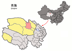
County-level city in Qinghai, China
Delingha (Chinese : 德令哈 ; Tibetan : གཏེར་ལིན་ཁ། ), or Delhi (Mongolian : ᠳᠡᠯᠡᠬᠡᠢ ᠬᠣᠲᠠ Haixi Mongol and Tibetan Autonomous Prefecture in northern Qinghai province, China. It is located approximately 200 km (120 mi) southeast of the Da Qaidam Administrative Region . It is a mainly industrial county-level city . The Bayin River divides the city into two parts: Hedong and Hexi . Because the prefecture seat is located in Hedong, it is slightly more flourishing than Hexi, which is chiefly agricultural.[ 1]
Established in 1988, Delingha administers seven township-level divisions covering an area of 27,700 km2 (10,700 sq mi) and has a total population of 78,184, making it the smallest of the five cities in Qinghai. The name of the city comes from Mongolian and means "golden world" (ᠠᠯᠲᠠᠨ ᠳᠡᠯᠡᠬᠡᠢ ),[ 1] Da Qaidam administrative zone merged into Delingha in mid-2018.
Administrative divisions
Delingha is divided into 3 subdistricts , 3 towns , and 1 township .
Name
Simplified Chinese
Hanyu Pinyin
Tibetan
Wylie
Mongolian (traditional script )
Mongolian (Cyrillic )
Administrative division code
Subdistricts
Hexi Subdistrict
河西街道 Héxī Jiēdào ཆུ་ནུབ་སྲང་ལམ།
chu nub srang lam ᠭᠣᠣᠯ ᠤᠨ ᠬᠣᠢᠨᠠᠬᠢ ᠵᠡᠭᠡᠯᠢ ᠭᠤᠳᠤᠮᠵᠢ
Голын хойнох зээл гудамж 632802001
Hedong Subdistrict
河东街道 Hédōng Jiēdào ཆུ་ཤར་སྲང་ལམ།
chu shar srang lam ᠭᠣᠣᠯ ᠤᠨ ᠡᠮᠦᠨᠡᠬᠢ ᠵᠡᠭᠡᠯᠢ ᠭᠤᠳᠤᠮᠵᠢ
Голын өмнөх зээл гудамж 632802002
Railway Station Subdistrict
火车站街道 Huǒchēzhàn Jiēdào མེ་འགོར་ས་ཚུགས་སྲང་ལམ།
me 'gor sa tshugs srang lam ᠭᠠᠯᠲᠤ ᠲᠡᠷᠭᠡᠨ ᠥᠷᠲᠡᠭᠡᠨ ᠦ ᠵᠡᠭᠡᠯᠢ ᠭᠤᠳᠤᠮᠵᠢ
Галт тэргэн өртөөний зээл гудамж 632802003
Towns
Gahai Town
尕海镇 Gǎhǎi Zhèn ཀ་ཧྭའེ་གྲོང་རྡལ།
ka hwa'e grong rdal ᠪᠠᠭᠠᠬᠤᠨᠠᠭᠤᠷ ᠪᠠᠯᠭᠠᠰᠤᠨ
Бааахнуур балгас 632802100
Hoit Taria Town
怀头他拉镇 Huáitóutālā Zhèn ཧྭའེ་ཐིག་ཐ་ལ་གྲོང་རྡལ།
hwa'e thig tha la grong rdal ᠬᠣᠢᠲᠤᠲᠠᠷᠢᠶᠠ ᠪᠠᠯᠭᠠᠰᠤᠨ
Хойтдаариа балгас 632802101
Hurleg Town
柯鲁柯镇 Kēlǔkē Zhèn ཁི་ལུའུ་ཁི་གྲོང་རྡལ།
khi lu'u khi grong rdal ᠬᠥᠷᠯᠥᠩ ᠪᠠᠯᠭᠠᠰᠤᠨ
Хэрлон балгас 632802102
Township
Suj Township
蓄集乡 Xùjí Xiāng ཕྱུགས་སྐྱིལ་ཡུལ་ཚོ།
phyugs skyil yul tsho ᠰᠦᠵᠢ ᠰᠤᠮᠤᠨ
Сүж суман 632802200
Geography
Climate
Delingha has a cool semi-arid climate (Köppen BSk ) just moist enough to avoid being a cool arid climate (BWk ), characterised by warm summers with moderate rainfall and frigid to freezing, dry winters.
Climate data for Delingha, elevation 2,982 m (9,783 ft), (1991–2020 normals, extremes 1971–2010)
Month
Jan
Feb
Mar
Apr
May
Jun
Jul
Aug
Sep
Oct
Nov
Dec
Year
Record high °C (°F)
9.6
12.3
18.9
27.4
29.3
29.4
34.7
34.2
31.7
22.4
14.6
8.4
34.7
Mean daily maximum °C (°F)
−2.4
2.3
7.9
14.1
18.2
21.2
23.7
23.6
19.1
12.2
4.7
−0.9
12.0
Daily mean °C (°F)
−9.8
−5.2
0.4
6.8
11.4
14.8
17.2
16.8
12.0
4.4
−3.0
−8.6
4.8
Mean daily minimum °C (°F)
−15.3
−11.0
−5.7
0.1
5.1
9.3
11.8
11.4
6.5
−1.3
−8.3
−13.9
−0.9
Record low °C (°F)
−30.9
−32.4
−21.3
−10.9
−7.4
−2.5
0.5
−0.9
−8.9
−14.2
−20.3
−28.4
−32.4
Average precipitation mm (inches)
4.9
3.8
6.2
6.4
26.2
45.9
51.7
39.1
24.1
6.1
2.9
1.9
219.2
Average precipitation days (≥ 0.1 mm)
3.6
2.2
2.3
2.5
6.2
10.5
11.5
9.3
6.2
1.9
1.3
1.9
59.4
Average snowy days
4.7
3.8
3.3
3.3
1.9
0.2
0
0
0
2.0
2.1
2.6
23.9
Average relative humidity (%)
41
34
28
27
35
44
48
46
45
36
35
38
38
Mean monthly sunshine hours
226.4
219.9
253.1
270.4
272.5
248.8
250.9
252.2
241.3
260.5
237.1
226.5
2,959.6
Percent possible sunshine
73
71
68
68
62
57
57
61
66
76
79
76
68
Source 1: China Meteorological Administration [ 3] [ 4]
Source 2: Weather China[ 5]
Transportation
The Haixi Delingha Airport and Delingha railway station serve the city.
Economy and industry
Delingha will be home to a 400 million yuan "Mars village" used by the Chinese Academy of Sciences to plan future Mars explorations missions .[ 6]
At an altitude of 3,000 meters (9,800 ft), a 50 MW concentrated solar power plant with parabolic trough opened in 2018.[ 7]
References


