Share to: share facebook share twitter share wa share telegram print page


Bramhapuri

Bramhapuri
Village
Overview of Bramhapuri Town
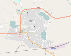
Map
Bramhapuri
Location in Bramhapuri taluka
Coordinates: 20°36′24″N 79°51′52″E / 20.6068°N 79.8644°E / 20.6068; 79.8644
Country India
StateMaharashtra
RegionVidarbha
DistrictChandrapur
TalukaBramhapuri
Area
 • Total
15 km2 (6 sq mi)
Elevation
229.5 m (753.0 ft)
Population
 (2011)
 • Total
36,025
 • Density2,400/km2 (6,200/sq mi)
Languages
 • OfficialMarathi
Time zoneUTC+5:30 (IST)
PIN
441206
Telephone code07177
Vehicle registrationMH34
Nearest cityNagpur
Tehsil Office, Bramhapuri

Bramhapuri is a town and eponymous headquarters of Bramhapuri taluka in Chandrapur district in the state of Maharashtra, India.

Geography

Bramhapuri is one of the six divisions located in the northeastern part of Chandrapur district, Maharashtra at 20°22′N 79°31′E / 20.36°N 79.51°E / 20.36; 79.51 and has an average elevation of 229.5 metres (753 feet). The town is located in the 73rd Vidhan Sabha constituency in Maharashtra.

Demographics

According to 2011 Indian census,[1] Brahmapuri Municipal Council administers over 8,575 households composing a population of 36,025. Males constitute 50.10% of the total population and females 49.90%. The population of children, aged 0 to 6, is 3,283, which constitue 9.11 % of the total population of Brahmapuri.

In Brahmapuri Municipal Council, the female sex ratio is of 996 against the state average of 929. The child sex ratio in Brahmapuri is around 990 compared to the Maharashtra state average of 894. The literacy rate of Brahmapuri city is 89.69 % higher than state average of 82.34 %. In Brahmapuri, male literacy is around 93.55 % while the female literacy rate is 85.82 %.

73% of the population follows Hinduism and 21% population follows Buddhism. Muslims account for around 4.5%, Christians 0.5%, Sikhs 0.37%, Jains 0.19% and others 0.42%.

Year Male Female Total Population Change Religion (%)
Hindu Muslim Christian Sikhs Buddhist Jain Other religions and persuasions Religion not stated
2001[2] 15957 15250 31207 - 72.503 4.249 0.477 0.352 19.422 0.218 2.256 0.522
2011[3] 18052 17973 36025 0.154 73.071 4.500 0.500 0.369 20.899 0.194 0.419 0.047

History

Bramhapuri was a city in the Satavahana dynasty, with many burnt-brick houses, numerous glass beads and coins.[4] Many bronze objects were excavated from there, many of which are Indian but few were also of Roman and Italian origin, that can be attributed to the Satavahana period.[5]

Climate

The climate here is generally hot and dry whereas in the rainy season it is humid and the rainfall is quite heavy. The temperature in summer goes above 45 °C and in winter drops below 10 °C. In the last few years this town has been listed among the top five hottest cities of India.[6]

Climate data for Bramhapuri (1991–2020, extremes 1956–2020)
Month Jan Feb Mar Apr May Jun Jul Aug Sep Oct Nov Dec Year
Record high °C (°F) 37.4
(99.3)
39.1
(102.4)
42.5
(108.5)
46.5
(115.7)
48.3
(118.9)
47.7
(117.9)
40.2
(104.4)
38.3
(100.9)
37.6
(99.7)
38.7
(101.7)
39.1
(102.4)
37.2
(99.0)
47.7
(117.9)
Mean daily maximum °C (°F) 29.5
(85.1)
32.6
(90.7)
36.9
(98.4)
40.7
(105.3)
42.9
(109.2)
37.7
(99.9)
31.6
(88.9)
30.6
(87.1)
32.2
(90.0)
33.0
(91.4)
31.7
(89.1)
29.9
(85.8)
34.1
(93.4)
Mean daily minimum °C (°F) 12.9
(55.2)
15.9
(60.6)
20.1
(68.2)
24.9
(76.8)
28.6
(83.5)
26.7
(80.1)
24.8
(76.6)
24.5
(76.1)
24.2
(75.6)
21.3
(70.3)
17.2
(63.0)
13.3
(55.9)
21.0
(69.8)
Record low °C (°F) 0.8
(33.4)
5.1
(41.2)
10.3
(50.5)
12.8
(55.0)
13.4
(56.1)
14.2
(57.6)
13.9
(57.0)
14.0
(57.2)
14.9
(58.8)
7.6
(45.7)
6.2
(43.2)
2.6
(36.7)
0.8
(33.4)
Average rainfall mm (inches) 8.7
(0.34)
12.6
(0.50)
17.9
(0.70)
15.8
(0.62)
20.3
(0.80)
181.3
(7.14)
410.5
(16.16)
379.0
(14.92)
191.3
(7.53)
45.8
(1.80)
11.5
(0.45)
4.7
(0.19)
1,299.4
(51.16)
Average rainy days 0.7 1.1 1.4 1.7 1.6 8.2 15.6 14.8 9.1 2.5 0.5 0.1 57.3
Average relative humidity (%) (at 17:30 IST) 42 39 36 31 27 53 72 77 71 60 51 44 50
Source: India Meteorological Department[7][8][9]

References

  1. ^ "Census of India 2001: Data from the 2001 Census, including cities, villages and towns (Provisional)". Census Commission of India. Archived from the original on 16 June 2004. Retrieved 1 November 2008.
  2. ^ Census India 2001.
  3. ^ Census India 2011.
  4. ^ Allchin, F. R.; Erdosy, George (7 September 1995). The Archaeology of Early Historic South Asia: The Emergence of Cities and States. Cambridge University Press. ISBN 9780521376952.
  5. ^ Dhavalikar, M.K. (2004). Satavahana Art. Sharada Publishing House. p. 91. ISBN 81-88934-04-6.
  6. ^ "Bhira in Maharashtra hottest in India on Saturday". The Times of India. 26 March 2017.
  7. ^ "Climatological Tables of Observatories in India 1991-2020" (PDF). India Meteorological Department. Retrieved 8 April 2024.
  8. ^ "Station: Brahmapuri Climatological Table 1981–2010" (PDF). Climatological Normals 1981–2010. India Meteorological Department. January 2015. pp. 157–158. Archived from the original (PDF) on 5 February 2020. Retrieved 3 April 2020.
  9. ^ "Extremes of Temperature & Rainfall for Indian Stations (Up to 2012)" (PDF). India Meteorological Department. December 2016. p. M140. Archived from the original (PDF) on 5 February 2020. Retrieved 3 April 2020.


Kembali kehalaman sebelumnya


Index: pl ar de en es fr it arz nl ja pt ceb sv uk vi war zh ru af ast az bg zh-min-nan bn be ca cs cy da et el eo eu fa gl ko hi hr id he ka la lv lt hu mk ms min no nn ce uz kk ro simple sk sl sr sh fi ta tt th tg azb tr ur zh-yue hy my ace als am an hyw ban bjn map-bms ba be-tarask bcl bpy bar bs br cv nv eml hif fo fy ga gd gu hak ha hsb io ig ilo ia ie os is jv kn ht ku ckb ky mrj lb lij li lmo mai mg ml zh-classical mr xmf mzn cdo mn nap new ne frr oc mhr or as pa pnb ps pms nds crh qu sa sah sco sq scn si sd szl su sw tl shn te bug vec vo wa wuu yi yo diq bat-smg zu lad kbd ang smn ab roa-rup frp arc gn av ay bh bi bo bxr cbk-zam co za dag ary se pdc dv dsb myv ext fur gv gag inh ki glk gan guw xal haw rw kbp pam csb kw km kv koi kg gom ks gcr lo lbe ltg lez nia ln jbo lg mt mi tw mwl mdf mnw nqo fj nah na nds-nl nrm nov om pi pag pap pfl pcd krc kaa ksh rm rue sm sat sc trv stq nso sn cu so srn kab roa-tara tet tpi to chr tum tk tyv udm ug vep fiu-vro vls wo xh zea ty ak bm ch ny ee ff got iu ik kl mad cr pih ami pwn pnt dz rmy rn sg st tn ss ti din chy ts kcg ve 
Prefix: a b c d e f g h i j k l m n o p q r s t u v w x y z 0 1 2 3 4 5 6 7 8 9