Share to: share facebook share twitter share wa share telegram print page


Alvarado, Texas

Alvarado
Motto: 
"The Crossroads of Johnson County"[1]
Map
Map
Map
Map
Alvarado is located in Texas
Alvarado
Alvarado
Alvarado is located in the United States
Alvarado
Alvarado
Alvarado is located in North America
Alvarado
Alvarado
Coordinates: 32°23′23″N 97°14′12″W / 32.38972°N 97.23667°W / 32.38972; -97.23667
CountryUnited States
StateTexas
CountyJohnson
Incorporated (city)1885
Government
 • TypeManager-council government
Area
 • Total
4.89 sq mi (12.68 km2)
 • Land4.15 sq mi (10.76 km2)
 • Water0.74 sq mi (1.92 km2)
Elevation725 ft (221 m)
Population
 (2020)
 • Total
4,739
 • Density970/sq mi (370/km2)
Time zoneUTC-6 (Central (CST))
 • Summer (DST)UTC-5 (CDT)
ZIP code
76009
Area code(s)817, 682
FIPS code48-02260[4]
GNIS feature ID2409691[3]
Websitewww.cityofalvarado.org

Alvarado (/ˌælvəˈrd/ AL-və-RAY-doh) is the oldest city in Johnson County, Texas, United States. The population was 4,739 in 2020.[5]

The community's first sheriff, A. H. Onstoott, is credited with naming Alvarado for Alvarado, Veracruz, Mexico, where he fought in a battle during the Mexican–American War.[citation needed]

Geography

Alvarado is located in eastern Johnson County at the intersection of US Highway 67 and Interstate 35W. The city is 26 miles (42 km) south of the center of Fort Worth and 39 miles (63 km) southwest of Dallas.

According to the U.S. Census Bureau, Alvarado has a total area of 4.8 square miles (12.5 km2), of which 4.1 square miles (10.6 km2) are land and 0.73 square miles (1.9 km2), or 15.35%, are water.[6] The water area comprises Alvarado Park Lake, a reservoir on Turkey Creek 3 miles (5 km) southwest of the city. Alvarado is drained by the North Fork of Chambers Creek, a southeast-flowing stream that is part of the Trinity River watershed.

Alvarado's nearest neighboring communities are Venus to the east, Keene to the west, Burleson to the north, and Grandview to the south.

Climate

The climate in this area is characterized by hot, humid summers and generally mild to cool winters. According to the Köppen Climate Classification system, Alvarado has a humid subtropical climate, abbreviated "Cfa" on climate maps.[7]

Demographics

Historical population
CensusPop.Note
1880377
18901,543309.3%
19001,342−13.0%
19101,155−13.9%
19201,28411.2%
19301,210−5.8%
19401,3249.4%
19501,65625.1%
19601,90715.2%
19702,12911.6%
19802,70126.9%
19902,9188.0%
20003,28812.7%
20103,78515.1%
20204,73925.2%
2023 (est.)6,22531.4%
U.S. Decennial Census[8]
Alvarado racial composition as of 2020[5]
(NH = Non-Hispanic)[a]
Race Number Percentage
White (NH) 2,875 60.67%
Black or African American (NH) 256 5.4%
Native American or Alaska Native (NH) 22 0.46%
Asian (NH) 35 0.74%
Pacific Islander (NH) 3 0.06%
Some Other Race (NH) 13 0.27%
Mixed/Multi-Racial (NH) 248 5.23%
Hispanic or Latino 1,287 27.16%
Total 4,739

As of the 2020 United States census, there were 4,739 people, 1,388 households, and 1,184 families residing in the city.
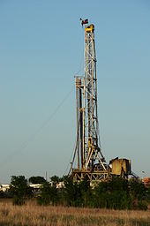
Barnett Shale gas drilling rig near Alvarado, Texas (2008)

Economy

Alvarado is a rural community with an economy that has been primarily agricultural with only a modest retail and industrial base. In recent years the trend has been away from agriculture and toward more urban development. In 2007 Sabre Tubular Structures built a new 200,000-square-foot (19,000 m2) facility located on 147 acres (59 ha) on the eastern side of town. Sabre has over 200 employees at this facility.[11] The city received a 2008 grant of $750,000 from the Texas Department of Agriculture for infrastructure improvements related to Sabre.[12]

Barnett Shale

In the latter part of the 2000s, development of natural gas wells in the Barnett Shale were a source of prosperity for the city and many property owners benefited from drilling activity, pipeline construction and royalty payments. As natural gas prices fell in 2009, drilling activity and royalty payments declined rapidly.

Recreation

  • Alvarado Park Lake is located on the west side of the city, three miles (5 km) west of I-35W.
  • Alvarado Parkway Park

Government

Texas Conference of Seventh-day Adventists building

The city uses a council-manager government, with a mayor and six city council members representing three wards, one being the mayor pro tempore.

The city's 2009–10 general fund budget was $3.9 million.[13]

Education

The city is served by the Alvarado Independent School District. There are no colleges or universities in Alvarado, although residents pay a Hill College maintenance tax and residents receive in-district student rates.

Notable people

See also

References

  1. ^ "City of Alvarado". City of Alvarado. Retrieved December 18, 2018.
  2. ^ "2019 U.S. Gazetteer Files". United States Census Bureau. Retrieved August 7, 2020.
  3. ^ a b U.S. Geological Survey Geographic Names Information System: Alvarado, Texas
  4. ^ "U.S. Census website". United States Census Bureau. Retrieved January 31, 2008.
  5. ^ a b "Explore Census Data". data.census.gov. Retrieved May 22, 2022.
  6. ^ "Geographic Identifiers: 2010 Census Summary File 1 (G001): Alvarado city, Texas". American Factfinder. U.S. Census Bureau. Archived from the original on February 13, 2020. Retrieved December 18, 2018.
  7. ^ Climate Summary for Alvarado, Texas
  8. ^ "Census of Population and Housing". Census.gov. Retrieved June 4, 2015.
  9. ^ https://www.census.gov/ [not specific enough to verify]
  10. ^ "About the Hispanic Population and its Origin". www.census.gov. Retrieved May 18, 2022.
  11. ^ "Sabre Tubular Structures Announces New Manufacturing Facility in Alvarado, Texas". Sabre Tubular Structures. Retrieved January 16, 2010.
  12. ^ "Commissioner Todd Staples Awards City Of Alvarado $750,000 For Economic Development". Texas Department of Agriculture. Archived from the original on January 26, 2010. Retrieved January 16, 2010.
  13. ^ "City of Alvarado Proposed Annual Budget Fiscal Year 2009-2010". City of Alvarado. Retrieved January 16, 2010.
  14. ^ "Austin Wolf". IMDb. Retrieved December 23, 2024.
  1. ^ Note: the US Census treats Hispanic/Latino as an ethnic category. This table excludes Latinos from the racial categories and assigns them to a separate category. Hispanics/Latinos can be of any race.[9][10]
Kembali kehalaman sebelumnya


Index: pl ar de en es fr it arz nl ja pt ceb sv uk vi war zh ru af ast az bg zh-min-nan bn be ca cs cy da et el eo eu fa gl ko hi hr id he ka la lv lt hu mk ms min no nn ce uz kk ro simple sk sl sr sh fi ta tt th tg azb tr ur zh-yue hy my ace als am an hyw ban bjn map-bms ba be-tarask bcl bpy bar bs br cv nv eml hif fo fy ga gd gu hak ha hsb io ig ilo ia ie os is jv kn ht ku ckb ky mrj lb lij li lmo mai mg ml zh-classical mr xmf mzn cdo mn nap new ne frr oc mhr or as pa pnb ps pms nds crh qu sa sah sco sq scn si sd szl su sw tl shn te bug vec vo wa wuu yi yo diq bat-smg zu lad kbd ang smn ab roa-rup frp arc gn av ay bh bi bo bxr cbk-zam co za dag ary se pdc dv dsb myv ext fur gv gag inh ki glk gan guw xal haw rw kbp pam csb kw km kv koi kg gom ks gcr lo lbe ltg lez nia ln jbo lg mt mi tw mwl mdf mnw nqo fj nah na nds-nl nrm nov om pi pag pap pfl pcd krc kaa ksh rm rue sm sat sc trv stq nso sn cu so srn kab roa-tara tet tpi to chr tum tk tyv udm ug vep fiu-vro vls wo xh zea ty ak bm ch ny ee ff got iu ik kl mad cr pih ami pwn pnt dz rmy rn sg st tn ss ti din chy ts kcg ve 
Prefix: a b c d e f g h i j k l m n o p q r s t u v w x y z 0 1 2 3 4 5 6 7 8 9