Share to: share facebook share twitter share wa share telegram print page


Alrance

Alrance
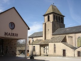
The town hall and church in Alrance
Location of Alrance
Map
Alrance is located in France
Alrance
Alrance
Alrance is located in Occitanie
Alrance
Alrance
Coordinates: 44°07′57″N 2°41′03″E / 44.1325°N 2.6842°E / 44.1325; 2.6842
CountryFrance
RegionOccitania
DepartmentAveyron
ArrondissementMillau
CantonRaspes et Lévezou
IntercommunalityLévézou Pareloup
Government
 • Mayor (2020–2026) Bernard Cluzel[1]
Area
1
35.43 km2 (13.68 sq mi)
Population
 (2022)[2]
333
 • Density9.4/km2 (24/sq mi)
Time zoneUTC+01:00 (CET)
 • Summer (DST)UTC+02:00 (CEST)
INSEE/Postal code
12006 /12430
Elevation719–971 m (2,359–3,186 ft)
(avg. 735 m or 2,411 ft)
1 French Land Register data, which excludes lakes, ponds, glaciers > 1 km2 (0.386 sq mi or 247 acres) and river estuaries.

Alrance (French pronunciation: [alʁɑ̃s]; Occitan: Alrança) is a commune in the Aveyron department in the Occitanie region of southern France.

Geography

Alrance is located some 30 km west of Millau and about 50 km north-east of Albi. The commune can be accessed by the D56 road which runs north-east from Durenque and intersects the road D25 in the commune. It continues north through the commune to Arvieu. The D25 comes south-east from Salmiech through most of the length of the commune and continues south-east to Villefranche-de-Panat. Access to the village is from the north-east on road D659 which runs off the D577 south of the Lac de Pareloup. The D659 runs south-west and ends at the village. The D528 also runs off the D25 in the south of the commune to the village.[3]

The commune is mostly farmland with some forest and covered by many country roads. There are a number of other hamlets and villages in the commune. These are:

  • L'Adrech
  • Bonneguide
  • Boussinesq
  • Le Bouviale
  • La Capelle Farcel
  • La Coste
  • Las Fenials
  • Flauvelou
  • Fretanels
  • Le Jouanesq
  • Lacan
  • Le Mas Nespoulous
  • Le Mas Viala
  • Le Mas Vialet
  • Montcouzac
  • Nazareth
  • La Niade
  • Pentezac
  • Peyrebrune
  • La Rouquette
  • Le Sales
  • La Vacaresse

A number of streams rise in the commune and flow to the Lac de Villefranche-de-Panat at the southern border of the commune. The streams include L'Alrance, Ruisseau du Lagasi, and several others. Some streams rise in the north of the commune and flow northwards eventually joining the river Céor which eventually flows to the Viaur at Castelpers.[3]

Neighbouring communes and villages

[3]

Administration

List of Successive Mayors of Alrance[4]

From To Name
1844 1856 Jean Joseph Terral
1856 1860 Adrien Seguret
1861 1862 Jean-Antoine Barthe
1862 1864 Jean-Joseph Terral
1864 1870 Jean-Antoine Barthe
1870 1871 François Gisquet
1871 1878 Joseph Gagraud
1878 1916 Adolphe Gagraud
1916 1919 Léopold Gautier
1919 1934 Adolphe Gagraud
1934 1953 Paul Serin
1953 1959 Gabriel Gintrand
1959 1971 Edouard Galtier
1971 1977 Auguste Fabre
1977 2001 Hubert Bonnefous
2001 2008 Jacques Montrozier
2008 2020 Jean-Pierre Drulhe
2020 2026 Bernard Cluzel

Population

The inhabitants of the commune are known as Alrançais or Alrançaises in French.[5]

Historical population
YearPop.±% p.a.
1968 625—    
1975 550−1.81%
1982 528−0.58%
1990 468−1.50%
1999 417−1.27%
2007 382−1.09%
2012 383+0.05%
2017 358−1.34%
Source: INSEE[6]

Sites and Monuments

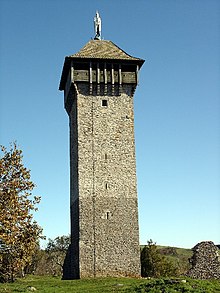
The Tower of Peyrebrune.
  • The Lac de Villefranche-de-Panat just south of the commune border provides power and water activities for the commune
  • The Church of Alrance and Church of La Capelle-Farcel
  • The Tower of Peyrebrune (a chapel and remains of a castle)

Notable People linked to the commune

  • Jean-Baptiste Angles, a missionary in Japan.

See also

References

  1. ^ "Répertoire national des élus: les maires". data.gouv.fr, Plateforme ouverte des données publiques françaises (in French). 2 December 2020.
  2. ^ "Populations de référence 2022" (in French). The National Institute of Statistics and Economic Studies. 19 December 2024.
  3. ^ a b c Google Maps
  4. ^ List of Mayors of France (in French)
  5. ^ Le nom des habitants du 12 - Aveyron, habitants.fr
  6. ^ Population en historique depuis 1968, INSEE
Kembali kehalaman sebelumnya


Index: pl ar de en es fr it arz nl ja pt ceb sv uk vi war zh ru af ast az bg zh-min-nan bn be ca cs cy da et el eo eu fa gl ko hi hr id he ka la lv lt hu mk ms min no nn ce uz kk ro simple sk sl sr sh fi ta tt th tg azb tr ur zh-yue hy my ace als am an hyw ban bjn map-bms ba be-tarask bcl bpy bar bs br cv nv eml hif fo fy ga gd gu hak ha hsb io ig ilo ia ie os is jv kn ht ku ckb ky mrj lb lij li lmo mai mg ml zh-classical mr xmf mzn cdo mn nap new ne frr oc mhr or as pa pnb ps pms nds crh qu sa sah sco sq scn si sd szl su sw tl shn te bug vec vo wa wuu yi yo diq bat-smg zu lad kbd ang smn ab roa-rup frp arc gn av ay bh bi bo bxr cbk-zam co za dag ary se pdc dv dsb myv ext fur gv gag inh ki glk gan guw xal haw rw kbp pam csb kw km kv koi kg gom ks gcr lo lbe ltg lez nia ln jbo lg mt mi tw mwl mdf mnw nqo fj nah na nds-nl nrm nov om pi pag pap pfl pcd krc kaa ksh rm rue sm sat sc trv stq nso sn cu so srn kab roa-tara tet tpi to chr tum tk tyv udm ug vep fiu-vro vls wo xh zea ty ak bm ch ny ee ff got iu ik kl mad cr pih ami pwn pnt dz rmy rn sg st tn ss ti din chy ts kcg ve 
Prefix: a b c d e f g h i j k l m n o p q r s t u v w x y z 0 1 2 3 4 5 6 7 8 9