Share to: share facebook share twitter share wa share telegram print page


A4 (Croatia)

A4 motorway shield
A4 motorway
Autocesta A4
Varaždinska autocesta
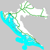
Map key - green in use Map key - blue other motorways
Route information
Part of European route E65 shield European route E71 shield
Length97.0 km (60.3 mi)
Major junctions
FromHungarian M7 motorway shield Hungarian M7
Major intersections D20 in Čakovec interchange
D530 in Ludbreg interchange
D528 in Varaždin interchange
D22 and
D24 in Novi Marof interchange
D10 in Sveta Helena interchange
To A3 in Ivanja Reka interchange
Location
CountryCroatia
CountiesCity of Zagreb, Zagreb, Varaždin, Međimurje
Major citiesZagreb, Varaždin, Čakovec
Highway system

The A4 motorway (Croatian: Autocesta A4) is a motorway in Croatia spanning 97.0 kilometres (60.3 mi).[1] It connects the nation's capital, Zagreb, to the city of Varaždin and to Budapest, Hungary via the Goričan border crossing.[2] The motorway represents a major north–south transportation corridor in Croatia and is a part of European routes E65 and E71.[3] The A4 motorway route also follows Pan-European corridor Vb.[4]

Apart from Zagreb and Varaždin, the A4 motorway runs near a number of Croatian cities, and connects to the rest of the Croatian motorway network east of Zagreb. The motorway route was completed in 2008. The motorway's national significance is reflected in the positive economic impact on the cities and towns it connects, as well as its importance to tourism in Croatia.[5] The genuine importance of the motorway as a transit route will be demonstrated upon completion of proposed expansion of Port of Rijeka and Rijeka transport node, since the A4 represents an integral part of the Rijeka–Zagreb–Budapest transport route.[6][7][8]

Motorway approaching a typical exit and a flyover, directional signs placed on a cantilevered gantry are visible to a side of the road
The A4 motorway at Varaždinske Toplice exit

As the route traverses hilly terrain, it requires a substantial number of viaducts and tunnels, as well as two major bridges to span the Drava and Mura rivers. The motorway consists of two traffic lanes and an emergency lane in each driving direction separated by a central reservation. There are no emergency lanes in the tunnels. All intersections of the A4 motorway are grade separated. As of October 2010, there are 12 exits and 3 rest areas operating along the route.[9] As the motorway is tolled using a ticket system, each exit includes a toll plaza. Exits south of the Sveta Helena mainline toll plaza have no toll plazas, as that part of the A4 route is not tolled. The same applies to the northernmost section between the Goričan exit and the Hungarian border.[10]

A motorway connecting Zagreb to Varaždin and Budapest was proposed in the early 1970s, but unlike the Zagreb–Rijeka or Zagreb–Belgrade motorways, no construction was actually carried out.[11] The first section of the road, later designated as the A4 motorway, was developed as a 6-kilometre (3.7 mi) two-lane road to serve as an interchange ramp in Ivanja Reka. The majority of the entire motorway was built between 1997 and 2003, leaving only a 1.6-kilometre (0.99 mi) section between the Goričan interchange and the Goričan–Letenye border crossing left to build. The section was fully completed on October 22, 2008. In 1998, construction costs were estimated at 850 million German marks (€434.5 million).[12] Although a 32-year concession for development of the motorway was awarded to Transeuropska Autocesta d.d. (TEA) in 1997, Hrvatske autoceste took over development, maintenance and management of the route in 2000 when the concession was cancelled, leading to a dispute with Astaldi, the majority owner of TEA.[13][14]

Route description

One motorway carriageway with two traffic lanes and an emergency lane, a directional traffic sign is placed next to the road, while a gantry supporting variable traffic signs is visible in the background
The A4 route near Novi Marof

The A4 motorway is a significant north–south motorway in the northern Croatia connecting the nation's capital, Zagreb, to the Hungarian M7 motorway at the Goričan border crossing[15] The southern terminus of the A4 motorway at the interchange in Ivanja Reka represents its junction with the rest of the Croatian motorway network via the A3 motorway.[16] As a part of the road network of Croatia, the motorway is a part of European route E65 and European route E71.[3] The motorway is of major importance to Croatia in terms of the development of its economy, notably tourism, as it represents the shortest and the most comfortable route between Budapest, Hungary and the Adriatic Sea. This particularly applies to tourist resorts on the Istria and Kvarner Gulf islands and to the Port of Rijeka, but it is also true for resorts in the Dalmatia region, served via the A1 motorway. The genuine importance of the motorway as a transit route will be demonstrated upon completion of the proposed expansion of the Port of Rijeka and Rijeka transport node. This expansion is planned to encompass the growth of the Port of Rijeka's cargo handling capacity,[6][7] improved railroad links and a new Rijeka bypass motorway linking the A6, via a new interchange, to the present routes of the A7 and A8 motorways. The project is, among other goals, aimed to increase traffic along the Croatian part of Pan-European corridor Vb, of which the A4 motorway is a part.[4][8][17]
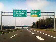
Directional traffic signs placed on a gantry
Ivanja Reka interchange, westbound approach along the A3

The motorway spans 97.0 kilometres (60.3 mi) between the Goričan border crossing to Hungary and Zagreb–Ivanja Reka interchange on the A3 motorway. Among other cities and towns, it connects to Čakovec via the D20, Ludbreg and Koprivnica via the D530 and D2, Varaždin via the D528, Novi Marof via the D22, Vrbovec and Križevci via the D10 state roads and Dugo Selo via the Ž3034 county road. Future development of the motorway will include additional rest areas and a possible expansion of interchanges.[2] The A4 motorway consists of two traffic lanes and an emergency lane in each driving direction along its entire length, except in tunnels where there are emergency bays instead. All existing interchanges are trumpet interchanges, except in Ivanja Reka, which is a modified cloverleaf. There is a number of rest areas along the motorway, providing various types of services ranging from parking spaces and restrooms to filling stations and restaurants.[9][18] As of October 2010, the motorway has 12 interchanges, providing access to numerous towns and cities and the Croatian state road network. The A4 motorway is concurrent with the D3 state road between the Komin and Ivanja Reka interchanges, although the D3 is not signposted along that section.[1] The motorway is operated by Hrvatske autoceste.[13][19]

An automatic traffic monitoring and guidance system is in place along the motorway. It consists of measuring, control and signaling devices, located in zones where driving conditions may vary—at interchanges, near viaducts, bridges, tunnels and in zones where fog and strong winds are known to occur. The system consists of variable traffic signs used to communicate changing driving conditions, possible restrictions and other information to motorway users.[20]

The A4 motorway runs through hills and plains crossed by a number of watercourses, requiring a number of bridges, viaducts and tunnels along the route. Particular attention to the environment is also required, due to the several water supply and natural heritage zones.[9]

Toll

A five lane toll plaza
Varaždin exit toll plaza

The A4 is a tolled motorway based on the vehicle classification in Croatia using a closed toll system. As of October 2010, toll charged along the A4 route between the Sveta Helena and Goričan mainline toll plazas varies depending on the length of route travelled and ranges from 7.00 kuna (€0.96) to 36.00 kuna (€4.93) for passenger cars and 22.00 kuna (€3.01) to 120.00 kuna (€16.44) for semi-trailer trucks.[21] The toll is payable in either Croatian kuna or euros using major credit cards, debit cards and a number of prepaid toll collection systems. The latter includes various types of smart cards issued by the motorway operator and ENC, an electronic toll collection (ETC) system which is shared at most motorways in Croatia and provides drivers with discounted toll rates for dedicated lanes at toll plazas.[22] The northernmost section of the motorway, between the border and Goričan interchange (inclusive) is not tolled. Similarly, the southernmost part of the A4 motorway route, located between Sveta Helena and Ivanja Reka interchanges (inclusive) is also toll-free, as it is a part of the Zagreb bypass, which services a significant volume of traffic.[10][21][23]

Notable structures
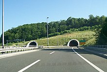
Motorway entering tunnel tubes
Hrastovec Tunnel

The A4 motorway Varaždin–Breznički Hum section route runs through hilly landscape requiring a number of viaducts and tunnels, especially along the Breznički Hum–Novi Marof section and around the Varaždinske Toplice exit. Each comprises four traffic lanes, while the viaducts have emergency lanes. Two most notable structures are the Hrastovec and Vrtlinovec tunnels, located to the south and north of the exit, respectively. Both of the tunnels consist of two tubes each, and each of them carry two traffic lanes. The Hrastovec Tunnel tubes are unequal in length, as the southbound tube is 498 metres (1,634 ft) long, while the northbound tube is 523 metres (1,716 ft) long.[24] The Vrtlinovec Tunnel southbound tube is 628 metres (2,060 ft) long and its northbound tube is 522 metres (1,713 ft) long, earning the distinction of being the longest tunnel on the A4 route.[25] There are two major bridges on the A4 motorway, both of them located north of Varaždin. The longest one is the Drava Bridge, carrying the motorway across the Drava River, measuring 507.7 metres (1,666 ft) long. There is also the Zrinski Bridge, carrying the A4 motorway across Mur River and across the Croatia–Hungary border, thus representing the northern terminus of the motorway, where northbound A4 traffic defaults to the Hungarian M7 motorway towards Nagykanizsa and Budapest. The 216-metre (709 ft) Zrinski Bridge was the final structure completed on the route. Both the Drava and Mura bridges carry six motorway lanes.[26]

History

Variable traffic signs placed on a gantry spanning three motorway lanes. The sign informs of overtaking ban for freight vehicles being enforced and that current temperature is 17 degrees Celsius. A two-tube tunnel portal is visible in the background.
Variable traffic signs ahead of Vrtlinovec Tunnel

A motorway connecting Zagreb to Varaždin and Budapest was proposed in the early 1970s, but unlike the Zagreb–Rijeka and Zagreb–Belgrade motorways, no construction was carried out.[11] Although the first section of the route, now designated as the A4 motorway, was completed in 1980, development for the motorway was proposed once again in 1991 to facilitate links between the Varaždin area, Zagreb and the remainder of the Croatian motorway network.[27] The route was added to the network of Pan-European transport corridors in June 1997, during the third Pan-European Transport Conference in Helsinki,[28] and on August 7, 1997, the government of the Republic of Croatia decided to establish the Autocesta Rijeka–Zagreb–Goričan company and award it a 28-year concession to develop, operate and maintain the route as a six-lane motorway. The route consisted of the entire Croatian section of the Pan-European corridor Vb except for 20.8-kilometre (12.9 mi) of the Lučko–Ivanja Reka section of the A3 motorway, which was already in use as a part of Zagreb bypass.[29]

Motorway border crossing
Letenye-Goričan border crossing, Hungarian side of the border

Later that same year, on May 14, 1998, the government signed an agreement with Astaldi, regulating construction of the Zagreb Goričan motorway by 2000.[30] On December 11, 1997, pursuant to the agreement, the government established the Autocesta Rijeka–Zagreb company to take the place of the Autocesta Rijeka–Zagreb–Goričan company, and awarded it the 28-year concession to develop, maintain and operate the Zagreb–Rijeka motorway, effectively excluding the Zagreb–Goričan motorway from the original concession.[31] At the same time, the Transeuropska autocesta d.o.o. (TEA) company was established by the government and awarded concession for development, operation and maintenance of the Zagreb–Goričan motorway.[32] Astaldi owned 51% of TEA, with the remainder owned by the Republic of Croatia. TEA was to secure financing of the project in 1998.[30][33] Construction began as scheduled; however, financial and legal problems ensued, and by 1999, the press speculated that Astaldi had given up the project, but Astaldi repeatedly denied these claims.[34][35] Ultimately, the government cancelled the contract and ceded the motorway to Croatian Roads Administration (ancestor of Hrvatske autoceste and Hrvatske ceste), leading Astaldi to turn to the commercial arbitration court in Vienna, which ruled in its favour. The Republic of Croatia was subsequently required to pay Astaldi 44.3 million euro in damages.[36]

In 1980, the 6-kilometre (3.7 mi) Popovec–Ivanja Reka section was the first part of the A4 motorway to be built, as a semi-motorway, for the new Ivanja Reka interchange on the motorway, later designated A3.[37] The first section completed was the 16-kilometre (9.9 mi) Goričan–Čakovec section, opened to traffic in 1997, followed by the 22.4-kilometre (13.9 mi) Komin–Popovec and the 15.58-kilometre (9.68 mi) Čakovec–Varaždin sections, completed in 1998.[38][39] In 2000, the 12.3-kilometre (7.6 mi) Breznički Hum–Komin section was finished,[27][40] and in 2003, the motorway route was nearly completed as the 23.25-kilometre (14.45 mi) Varaždin–Breznički Hum section and the second carriageway in the Popovec–Ivanja Reka section were built.[41][42] The final 1.6-kilometre (0.99 mi) section between the Goričan exit and the Hungarian border opened on October 22, 2008, the same day the final section of the A6 motorway was finalised, marking completion of the Budapest–Zagreb–Rijeka motorway.[43][44]

Road incidents

Traffic volume

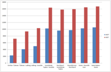
Bar graph indicating the motorway traffic volume
2009 A4 traffic volume by section

Traffic is regularly counted and reported by Hrvatske autoceste, operator of the motorway, and results are published by Hrvatske ceste. The largest annual average daily traffic (AADT) volume is often recorded in the Sveta Helena–Komin section, although all sections between Sveta Helena and Varaždin display similar AADT. AADT data for sections north of Varaždin show considerable drops in traffic volume. As the motorway traffic volume is measured through analysis of toll ticket sales, the southernmost section of the motorway, Ivanja Reka–Sveta Helena, is not included in the report. However, since the section is a part of the Zagreb bypass, it carries significantly heavier traffic than any other sections of the A4 motorway—in 2004, traffic volume along the toll-free section of the A4 motorway was approximately 24,000 vehicles per day (AADT) between the Kraljevečki Novaki and Sveta Helena interchanges and nearly 41,000 vehicles per day between the Kraljevečki Novaki and Ivanja Reka interchanges. Traffic volume measured on the Ivanja Reka–Ivanić Grad section of the A3 motorway increased by 30%, hinting at a similar increase in traffic volume on the A4 route south of Sveta Helena.[46]

Variations between AADT and average summer daily traffic (ASDT) traffic volumes are attributed to the fact that the motorway carries substantial tourist traffic to the Adriatic Sea resorts.[47]

A4 traffic volume details
Road Counting site AADT ASDT Notes
Croatian A4 motorway shield A4 1303 Čakovec north 2,687 8,841 Between Goričan and Čakovec interchanges.
Croatian A4 motorway shield A4 1306 Ludbreg north 4,308 10,829 Between Čakovec and Ludbreg interchanges.
Croatian A4 motorway shield A4 1212 Varaždin north 5,220 11,874 Between Varaždin and Ludbreg interchanges.
Croatian A4 motorway shield A4 1215 Varaždinske Toplice north 9,800 17,041 Between Varaždinske Toplice and Varaždin interchanges.
Croatian A4 motorway shield A4 1220 Novi Marof north 9,089 16,365 Between Novi Marof and Varaždinske Toplice interchanges.
Croatian A4 motorway shield A4 1225 Breznički Hum north 9,232 16,526 Between Breznički Hum and Novi Marof interchanges.
Croatian A4 motorway shield A4 1229 Komin north 9,642 16,934 Between Komin and Breznički Hum interchanges.
Croatian A4 motorway shield A4 2002 Sveta Helena north 9,988 17,220 Between Sveta Helena and Komin interchanges.

Rest areas

A view of a rest area and a filling station across the motorway
Ljubešćica rest area

As of October 2010, there are three rest areas along the A4 motorway. Legislation identifies four types of rest areas designated as types A through D: A-type rest areas comprise a full range of amenities, including a filling station, a restaurant and a hotel or motel; B-type rest areas have no lodging; C-type rest areas are very common and include a filling station and a café, but no restaurants or accommodations; D-type rest areas only offer parking spaces, possibly picnicking tables and benches, and restrooms. Even though rest areas found along the A4 motorway generally follow this ranking system, there are considerable variations, as some of them offer extra services. The filling stations regularly have small convenience stores, and some of them may offer LPG fuel.[48]

The primary motorway operator, Hrvatske autoceste (HAC), leases the A, B and C type rest areas to various operators through public tenders. As of October 2010, there are two such rest area operators on the A4 motorway: INA and Crodux. The rest area operators are not permitted to sub-lease the fuel operations. The A4 motorway rest areas are accessible from both directions of the motorway and operate 24 hours a day, 7 days a week.[18]

List of A4 motorway rest areas
County km Name[2] Operators Notes[18]
Varaždin 26.9 Varaždin HAC Facilities found at Varaždin rest area comprise parking area only.
44.7 Ljubešćica INA Facilities found at Ljubešćica rest area comprise a filling station selling petrol and diesel fuel, a café and restrooms.[49]
City of Zagreb 86.3 Sesvete Crodux Facilities found at Sesvete rest area comprise a filling station selling petrol and diesel fuel, a restaurant, a café and restrooms.
1.000 mi = 1.609 km; 1.000 km = 0.621 mi

Exit list

County km Exit Name[2] Destination[1][3] Notes
Međimurje 0.0 Border crossing within the EU Goričan border crossing M7
E65
E71
Goričan border crossing to Hungary[15]
The motorway extends as Hungarian M7 motorway towards Nagykanizsa and Budapest.
The northern terminus of European routes E65/E71 concurrency
The northern terminus of the motorway
1.3 1 GP Goričan D3 Connection to Goričan border crossing to Hungary
2.8 2 Goričan D3 Connection to Goričan
4.7 Toll plaza traffic sign Goričan toll plaza
16.9 3 Čakovec D20 Connection to Čakovec and Prelog
Varaždin 23.1 Drava River Bridge
25.0 4 Ludbreg D530 Connection to Varaždin and Lubreg via D2 state road
26.9 Rest area traffic sign Drava rest area
32.7 5 Varaždin D528 Connection to Varaždin via D3 state road and to D2 state road junction west of Varaždin
36.9 Vrtlinovec Tunnel
38.6 6 Varaždinske Toplice D526 Connection to Varaždinske Toplice and to D24 state road
39.2 Hrastovec Tunnel
44.7 Rest area traffic sign Ljubešćica rest area
47.0 7 Novi Marof D24
D22
Connection to Novi Marof and Križevci via D22 state road
56.6 8 Breznički Hum D3 Connection to Breznički Hum
Zagreb County 68.8 9 Komin D3 Connection to Komin
77.2 Toll plaza traffic sign Sveta Helena toll plaza
79.2 10 Sveta Helena D10
Ž3016
Connection to Vrbovec and Križevci via D10 expressway.
Connection to Rakovec, Sveta Helena and Donja Zelina (D3) (via the Ž3016)
The eastern terminus of Zagreb bypass.
City of Zagreb 86.3 Rest area traffic sign Sesvete rest area
90.4 11 Popovec D3 Connection to Popovec and Soblinec (D29)
The northern terminus of concurrency of the A4 motorway and the D3 state road.
93.6 12 Sesvete Ž3034 Connection to Sesvete and Kraljevečki Novaki, Dugo Selo
Zagreb County 96.4 13 Zagreb istok A3
E65
E70
E71
Connection to Zagreb via Slavonska Avenue, Slavonski Brod (eastbound A3) as well as A11, A1, A2 motorways, southern and western Zagreb bypass exits, Samobor and Slovenia (westbound A3).
The southern terminus of European routes E65/E71 concurrency
The southern terminus of D3 state road concurrency
The southern terminus of the motorway. Southbound A4 traffic defaults to westbound A3 motorway.
1.000 mi = 1.609 km; 1.000 km = 0.621 mi

See also

Sources

  1. ^ a b c "Odluka o razvrstavanju javnih cesta u državne ceste, županijske ceste i lokalne ceste" [Decision on categorization of public roads as state roads, county roads and local roads]. Narodne Novine (in Croatian). February 17, 2010. Retrieved September 6, 2010.
  2. ^ a b c d "Pravilnik o označavanju autocesta, njihove stacionaže, brojeva izlaza i prometnih čvorišta te naziva izlaza, prometnih čvorišta i odmorišta" [Regulation on motorway markings, chainage, interchange/exit/rest area numbers and names]. Narodne novine (in Croatian). May 6, 2003. Retrieved September 6, 2010.
  3. ^ a b c "European Agreement on main international traffic arteries (AGR) (with annexes and list of roads). Concluded at Geneva on 15 November 1975" (PDF). United Nations. Retrieved July 29, 2011.
  4. ^ a b "Transport : launch of the Italy-Turkey pan-European Corridor through Albania, Bulgaria, Former Yugoslav Republic of Macedonia and Greece". European Union. September 9, 2002. Retrieved September 6, 2010.[permanent dead link]
  5. ^ Jelena Lončar (December 14, 2007). "Međuovisnost prometa i turizma u Hrvatskoj" [Interdependency of transport and tourism in Croatia] (in Croatian). geografija.hr. Archived from the original on June 9, 2011. Retrieved September 6, 2010.
  6. ^ a b "Proširenje lučkih kapaciteta u Rijeci" [Expansion of Port of Rijeka facilities] (in Croatian). Croatian Radiotelevision. October 3, 2010. Archived from the original on May 3, 2010. Retrieved October 8, 2010.
  7. ^ a b Darko Pajić (July 3, 2010). "Četiri poslovne zone za 40 milijuna tona tereta riječke luke" [Four business zones for 40 million tons of cargo handled by Port of Rijeka]. Novi list (in Croatian). Archived from the original on July 8, 2010. Retrieved October 8, 2010.
  8. ^ a b "Realizacija prometnog čvora Rijeka kao pretpostavka gospodarskog razvoja županije" [Execution of Rijeka transport node as a precondition of economic development of the county] (PDF) (in Croatian). Primorje-Gorski Kotar County. September 2, 2003. Archived from the original (PDF) on June 13, 2011. Retrieved October 8, 2010.
  9. ^ a b c "Croatian Motorways (pp. 282–307)". Hrvatske autoceste. Archived from the original on 2011-02-18. Retrieved October 15, 2010.
  10. ^ a b "Toll payment conditions". Hrvatske autoceste. Archived from the original on 2011-07-18. Retrieved July 29, 2011.
  11. ^ a b Tihomir Ponoš (June 27, 2004). "Naša ideja je bila izgraditi ono što smo zvali 'hrvatski križ'" [Our idea was to build what we called 'Croatian cross'] (PDF). Vjesnik (in Croatian). Archived from the original (PDF) on July 16, 2007. Retrieved October 15, 2010.
  12. ^ "Otvorena dionica na autocesti Zagreb–Goričan" [Zagreb–Goričan motorway section opens] (in Croatian). Croatian Radiotelevision. July 31, 1998. Archived from the original on March 5, 2016. Retrieved October 15, 2010.
  13. ^ a b "Zakon o javnim cestama" [Public Roads Act]. Narodne Novine (in Croatian). December 14, 2004. Retrieved September 6, 2010.
  14. ^ "Mission". Hrvatske autoceste. Archived from the original on 2011-08-26. Retrieved July 29, 2011.
  15. ^ a b "Karta graničnih prijelaza i područja carinskih ispostava" [Map of border crossings and customs office areas] (PDF). Customs Administration of the Republic of Croatia (in Croatian). March 6, 2008. Retrieved November 21, 2010.
  16. ^ "A4 (Croatia)" (Map). Google Maps. Retrieved September 17, 2010.
  17. ^ Crnjak, Mario; Puž, Goran (November 2007). Kapitalna prometna infrastruktura [Capital transport infrastructure] (PDF). Hrvatske autoceste. pp. 37–39. ISBN 978-953-7491-02-2. Archived from the original (PDF) on January 9, 2014. Retrieved October 11, 2010.
  18. ^ a b c "Rest Areas". Hrvatske autoceste. Archived from the original on 2011-07-20. Retrieved July 29, 2011.
  19. ^ "Overview of motorways and semi-motorways". HUKA. Archived from the original on July 15, 2011. Retrieved September 8, 2010.
  20. ^ Croatian Motorways. Hrvatske autoceste. 2007. pp. 130–133. ISBN 978-953-7491-09-3. Archived from the original (PDF) on 2011-02-18. Retrieved September 5, 2010.
  21. ^ a b "Price list". Hrvatske autoceste. Archived from the original on 2011-08-20. Retrieved July 29, 2011.
  22. ^ "Statistički podaci" [Electronic toll collection available on HAC, ARZ and BINA Istra motorways] (in Croatian). HUKA. Archived from the original on July 21, 2011. Retrieved August 28, 2010.
  23. ^ "New 600 million Euro bypass". Jutarnji list (in Croatian). September 29, 2008. Archived from the original on 2010-11-30.
  24. ^ Branko Nadilo (2007). "Šezdeset godina postojanja Viadukta" [Sixty years of Viadukt] (PDF). Građevinar (in Croatian) (59): 901. Archived from the original (PDF) on July 18, 2011. Retrieved October 15, 2010.
  25. ^ "U cijelosti probijen tunel Vrtlinovec" [Vrtlinovec Tunnel fully excavated] (in Croatian). Croatian Radiotelevision. July 14, 2003. Archived from the original on March 5, 2016. Retrieved October 15, 2010.
  26. ^ "Autocesta A4 - Goričan–Zagreb - Most Mura" [A4 motorway - Goričan–Zagreb - Mura Bridge] (in Croatian). Hrvatske autoceste. Archived from the original on 2011-08-02. Retrieved July 29, 2011.
  27. ^ a b Karmen Gumbas (October 11, 2000). "Račan: Nema više otvaranja cesta s nepotpunom dozvolom" [Račan: No further roads shall open without complete licenses]. Vjesnik (in Croatian). Retrieved October 14, 2010.[permanent dead link]
  28. ^ Tanja Poletan Jugović (April 11, 2006). "The integration of the Republic of Croatia into the Pan-European transport corridor network". Pomorstvo. 20 (1). University of Rijeka, Faculty of Maritime Studies: 49–65. Retrieved October 14, 2010.
  29. ^ "Odluka o osnivanju dioničkog društva Autocesta Rijeka - Zagreb - Goričan d.d. i dodjeli koncesije za građenje i gospodarenje autocestom Rijeka - Zagreb - Goričan" [Decision on founding of Rijeka - Zagreb - Goričan Motorway joint stock company and granting of concession regulating construction and management of Rijeka - Zagreb - Goričan motorway]. Narodne Novine (in Croatian). August 7, 1997. Archived from the original on April 2, 2015. Retrieved October 14, 2010.
  30. ^ a b "Potpisan ugovor o financiranju autoceste Zagreb–Goričan" [Zagreb–Goričan motorway financing agreement signed] (in Croatian). Croatian Radiotelevision. May 14, 1998. Archived from the original on August 31, 2014. Retrieved October 14, 2010.
  31. ^ "Odluka o osnivanju dioničkog društva Autocesta Rijeka - Zagreb d.d. i dodjeli koncesije za građenje i gospodarenje autocestom Rijeka - Zagreb" [Decision on founding of Rijeka - Zagreb Motorway joint stock company and granting of concession regulating construction and management of Rijeka - Zagreb motorway]. Narodne Novine (in Croatian). December 11, 1997. Archived from the original on April 2, 2015. Retrieved September 6, 2010.
  32. ^ "Odluka o dodjeli koncesije za građenje i gospodarenje autocestom Zagreb - Goričan" [Decision on granting of concession regulating management of Zagreb - Goričan motorway]. Narodne Novine (in Croatian). July 24, 1998. Retrieved October 14, 2010.
  33. ^ "Ministar Pavlović: Obveznice za autocestu Zagreb-Goričan neće se izdavati" [Minister Pavlović: No bonds shall be issued for Zagreb-Goričan motorway] (in Croatian). Croatian Radiotelevision. October 14, 1999. Archived from the original on April 2, 2015.
  34. ^ Mladen Jambrović (May 13, 1999). "Talijanska tvrtka Astaldi ne odustaje od projekta autoceste Zagreb - Goričan" [Italian company Astaldi not giving up Zagreb - Goričan motorway project] (PDF). Vjesnik (in Croatian). Retrieved October 14, 2010.[permanent dead link]
  35. ^ "Radovi na autocesti Zagreb–Goričan" [Zagreb–Goričan motorway works] (in Croatian). Croatian Radiotelevision. December 28, 1999. Archived from the original on August 31, 2014. Retrieved October 14, 2010.
  36. ^ "Croatia to pay 79 mln to Hypo Bank". New Europe. November 3, 2008. Retrieved October 14, 2010.[permanent dead link]
  37. ^ "Mostovi, vijadukti, nadvožnjaci i podvožnjaci" [Bridges, viaducts, flyovers and underpasses]. Hidroelektra. Archived from the original on May 26, 2009. Retrieved October 14, 2010.
  38. ^ "Dionica Sv.Helena-Komin" [Sveta Helena-Komin section] (in Croatian). Konstruktor. Archived from the original on July 27, 2011. Retrieved October 14, 2010.
  39. ^ "Otvorena dionica autoceste Varaždin-Čakovec" [Varaždin-Čakovec motorway section opens] (in Croatian). Croatian Radiotelevision. July 24, 1998. Archived from the original on August 31, 2014. Retrieved October 14, 2010.
  40. ^ "Dionica Komin-Breznički Hum" [Komin-Breznički Hum section] (in Croatian). Konstruktor. Archived from the original on July 27, 2011. Retrieved October 14, 2010.
  41. ^ "Otvorena dionica Novi Marof-Varaždin, autoceste Zagreb–Goričan" [Zagreb–Goričan motorway Novi Marof-Varaždin section opens] (in Croatian). Croatian Radiotelevision. November 16, 2003. Archived from the original on August 31, 2014. Retrieved October 14, 2010.
  42. ^ "Otvorena dionica Breznički Hum-Novi Marof na autocesti Zagreb–Goričan" [Zagreb–Goričan motorway Breznički Hum-Novi Marof section opens] (in Croatian). Croatian Radiotelevision. June 24, 2003. Archived from the original on August 31, 2014. Retrieved October 14, 2010.
  43. ^ "Ministri prometa Hrvatske i Mađarske otvorili most Muru s pristupnim cestama" [Croatian and Hungarian transport ministers open Mura Bridge and access roads] (in Croatian). Ministry of Sea, Transport and Infrastructure. October 22, 2008. Retrieved October 14, 2010.[permanent dead link]
  44. ^ Tomislav Grdić, Damir Herceg (October 23, 2008). "Otvoren koridor Rijeka-Zagreb-Budimpešta" [Rijeka-Zagreb-Budapest corridor opens]. Vjesnik (in Croatian). Retrieved October 14, 2010.[permanent dead link]
  45. ^ "12 dead as bus carrying Polish pilgrims to Bosnia crashes in Croatia". euronews. 2022-08-06. Retrieved 2022-08-08.
  46. ^ "Sjeverna tangenta - Studija (str.90)" [Northern tangent - study (p.90)] (PDF) (in Croatian). City of Zagreb. July 27, 2006. Retrieved October 1, 2010.
  47. ^ "Brojenje prometa na cestama Republike Hrvatske godine 2015" [Traffic counting on the roadways of Croatia in 2015] (PDF). Hrvatske ceste (in Croatian). April 2016. Archived from the original (PDF) on 2016-07-01. Retrieved 2016-08-09.
  48. ^ "Basic types and offer of roadside service facilities". Hrvatske autoceste. Archived from the original on 2011-07-13. Retrieved July 29, 2011.
  49. ^ "Petrol Station Search - A3 motorway". INA. Archived from the original on 24 September 2010. Retrieved September 26, 2010.
Kembali kehalaman sebelumnya


Index: pl ar de en es fr it arz nl ja pt ceb sv uk vi war zh ru af ast az bg zh-min-nan bn be ca cs cy da et el eo eu fa gl ko hi hr id he ka la lv lt hu mk ms min no nn ce uz kk ro simple sk sl sr sh fi ta tt th tg azb tr ur zh-yue hy my ace als am an hyw ban bjn map-bms ba be-tarask bcl bpy bar bs br cv nv eml hif fo fy ga gd gu hak ha hsb io ig ilo ia ie os is jv kn ht ku ckb ky mrj lb lij li lmo mai mg ml zh-classical mr xmf mzn cdo mn nap new ne frr oc mhr or as pa pnb ps pms nds crh qu sa sah sco sq scn si sd szl su sw tl shn te bug vec vo wa wuu yi yo diq bat-smg zu lad kbd ang smn ab roa-rup frp arc gn av ay bh bi bo bxr cbk-zam co za dag ary se pdc dv dsb myv ext fur gv gag inh ki glk gan guw xal haw rw kbp pam csb kw km kv koi kg gom ks gcr lo lbe ltg lez nia ln jbo lg mt mi tw mwl mdf mnw nqo fj nah na nds-nl nrm nov om pi pag pap pfl pcd krc kaa ksh rm rue sm sat sc trv stq nso sn cu so srn kab roa-tara tet tpi to chr tum tk tyv udm ug vep fiu-vro vls wo xh zea ty ak bm ch ny ee ff got iu ik kl mad cr pih ami pwn pnt dz rmy rn sg st tn ss ti din chy ts kcg ve 
Prefix: a b c d e f g h i j k l m n o p q r s t u v w x y z 0 1 2 3 4 5 6 7 8 9