Wasterkingen
| Wasterkingen | |
|---|---|
 | |
| Basisdate | |
| Staat: | Schwiiz |
| Kanton: | Züri (ZH) |
| Bezirk: | Büüli |
| BFS-Nr.: | 0070 |
| Poschtleitzahl: | 8195 |
| Koordinate: | 677889 / 271764 |
| Höchi: | 393 m ü. M. |
| Flächi: | 3,95 km² |
| Iiwohner: | 589 (31. Dezämber 2022)[1] |
| Website: | www.wasterkingen.ch |
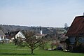
 Dorfzentrum Waschterchinge | |
| Charte | |
 | |
Waschterchinge (amtlich Wasterkingen) isch e politischi Gmäind im Bezirk Büüli im Kanton Züri, Schwiiz.
Geografi
Waschterchinge liit im nordweschtliche Änd vom Rafzerfeld a de Grenze zue Tüütschland. S Piet vo de Gmäind umfasst 49,2 % landwirtschaftlichi Flèchi, 43,1 % Wald, 5,3 % Sidligsflechi, 2 % Vercheersflechi und 0,3 % Gwässerflechi.[2]
Gschicht
Waschterchinge isch zum eschte Mal gnamset worde im Jaar 1102 als Watachingin.
Bevölkerigsentwicklig
Quälle: Bundesamt für Statistik 2005[3]
| Jaar | 1850 | 1860 | 1870 | 1880 | 1888 | 1900 | 1910 | 1920 |
| Iiwooner | 437 | 463 | 464 | 445 | 424 | 353 | 302 | 299 |
| Jaar | 1930 | 1941 | 1950 | 1960 | 1970 | 1980 | 1990 | 2000 |
| Iiwooner | 290 | 285 | 275 | 266 | 296 | 320 | 481 | 560 |
De Uusländeraatäil liit bi 7,7 % (Stand 2011).[2]
Religion
59 % vo de Iiwooner sind evangelisch-reformiert, 17 % sind römisch-katholisch (Stand 2011).[2]
Politik
Bi de Kantonsraatswaale 2011 hät s das Ergebnis ggee:[2] BDP 6,4 %, CVP 1,8 %, EDU 1,4 %, EVP 2,2 %, FDP 5,1 %. GLP 9,1 %, GP 9,1 %, SP 13,8 %, SVP 50,6 %, Suschtigi 0,4 %.
Gmäindspresidänt isch de Hans Frei (Stand 2012).
Wirtschaft
D Arbetslosigkäit isch im Jaar 2010 bi 1,8 % gläge.[2]
Tieläkt
D Wiiländer Mundart vo Waschterchinge ghöört zue de Oschtschwiizer Tieläkt.
Bilder
-
 Dorfiigang
 -
 Blick uf d Chile
 -
 Reschtaurant Truube
 -
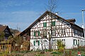 Rigelhuus
 -
 Rigelhuus
 -
 Chile
Chile


Literatur
- David Meili: Hexen in Wasterkingen: Magie und Lebensform in einem Dorf des frühen 18. Jahrhunderts. Basel 1980
Weblink
Fuessnote
- ↑ Ständige Wohnbevölkerung nach Staatsangehörigkeitskategorie, Geschlecht und Gemeinde, definitive Jahresergebnisse, 2022. Bei späteren Gemeindefusionen Einwohnerzahlen aufgrund Stand 2022 zusammengefasst. Abruf am 5. September 2023
- ↑ 2,0 2,1 2,2 2,3 2,4 Bundesamt für Statistik: Regionalporträts 2012: Kennzahlen aller Gemeinden (Site cha nüme abgrüeft wärde; Suche im Webarchiv) , Mai 2012
- ↑ Bundesamt für Statistik: Eidgenössische Volkszählung 2000: Bevölkerungsentwicklung der Gemeinden 1850–2000. Bern 2005 (Online uf bfs.admin.ch (Site cha nüme abgrüeft wärde; Suche im Webarchiv) , Date im Aahang (Site cha nüme abgrüeft wärde; Suche im Webarchiv) )
Content Disclaimer
Informasi ini disarikan dari Wikipedia dan disajikan kembali untuk tujuan edukasi. Konten tersedia di bawah lisensi CC BY-SA 3.0. Kami tidak bertanggung jawab atas ketidakakuratan data yang bersumber dari kontribusi publik tersebut.
- The information displayed on this website is sourced in part or in whole from Wikipedia and has been adapted for the purpose of restating it. We strive to provide accurate and relevant information, however:
- There is no guarantee of absolute accuracy. Wikipedia is an open, collaborative project that can be edited by anyone, so information is subject to change.
- It is not intended to constitute professional advice. The content displayed is for informational and educational purposes only. For important decisions (e.g., medical, legal, or financial), please consult a professional.
- Content copyright. Wikipedia is licensed under the Creative Commons Attribution-ShareAlike License (CC BY-SA). This means that content may be reused with appropriate attribution and shared under a similar license.
- Responsible use. Any risk arising from the use of information from this website is entirely the responsibility of the user.