Iffwil
| Iffwil | |
|---|---|
 | |
| Basisdate | |
| Staat: | Schwiiz |
| Kanton: | Bärn (BE) |
| Verwautigschreis: | Bärn-Mittuland |
| BFS-Nr.: | 0541 |
| Poschtleitzahl: | 3305 |
| Koordinate: | 602995 / 212542 |
| Höchi: | 560 m ü. M. |
| Flächi: | 5.0 km² |
| Iiwohner: | 433 (31. Dezämber 2022)[1] |
| Website: | www.iffwil.ch |
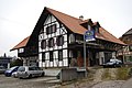
_165.JPG) Ifwiu | |
| Charte | |
 | |
Ifwiu (amtlech Iffwil) isch e politischi Gmeind im Verwautigschreis Bärn-Mittuland im Kanton Bärn, Schwyz.
Geografi
Ifwiu ligt uf em Rapperswiler Plateau. D Gmeindsflächi bsteit us 55,7 % langwirtschaftlecher Flächi, 36,6 % Waud, 7,6 % Sidligsflächi u 0,2 % süschtigi Flächi.[2] D Nachburgmeinde si Graferied, Iegischtoorf, Züzwiu, Bangerte, Schüne u Etzukofe.
Gschicht
Ifwiu isch zum erschte Mal gnennt worde im Jahr 1148 aus Iffenwilere. Bis zum 31. Dezämber 2009 het d Gmeind zum Bezirk Froubrunne ghört.
Ywohner
Quäuue: Bundesamt für Statistik 2005[3]
| Jahr | 1850 | 1860 | 1870 | 1880 | 1888 | 1900 | 1910 | 1920 |
| Ywohner | 374 | 381 | 390 | 383 | 350 | 339 | 357 | 369 |
| Jahr | 1930 | 1941 | 1950 | 1960 | 1970 | 1980 | 1990 | 2000 |
| Ywohner | 349 | 346 | 329 | 338 | 309 | 301 | 320 | 413 |
Dr Uusländeraateil isch 2010 bi 1,9 % gläge.[2]
Religion
79,4 % vo de Ywohner si evangelisch-reformiert, 7,5 % si römisch-katholisch (Stang 2000).[2]
Politik
Bi de Nationauraatswahle 2011 het s das Ergebnis ggää:[2] BDP 29,7 %, CVP 0,7 %, EVP 4,6 %, FDP 5,8 %. GLP 4,3 %, GP 7,6 %, SP 7,7 %, SVP 33,5 %, Suschtigi 6,1 %.
Gmeindspresidänt vo Ifwiu isch dr Heinz Knuchel (Stang 2013).
Wirtschaft
D Arbetslosigkeit isch im Jahr 2011 bi 0,4 % gläge.[2]
Sprach u Dialäkt
Bir Vouchszeuuig 2000 hei vo de 413 Ywohner 98,1 % Dütsch aus Houptsprach aaggää u 0,5 % Französisch.[2]
Dr Dialäkt vo Ifwiu ghört zum Hochalemannisch.
Biuder
-
 Gmeindshuus
 -
 Bushautsteuu
 -
 Riguhuus
_110.JPG)
_093.JPG)
_113.JPG)
Weblink
- www.iffwil.ch
- Anne-Marie Dubler: Ifwiu.. In: Historisches Lexikon vo dr Schwiiz.
Fuessnote
- ↑ Ständige Wohnbevölkerung nach Staatsangehörigkeitskategorie, Geschlecht und Gemeinde, definitive Jahresergebnisse, 2022. Bei späteren Gemeindefusionen Einwohnerzahlen aufgrund Stand 2022 zusammengefasst. Abruf am 5. September 2023
- ↑ 2,0 2,1 2,2 2,3 2,4 2,5 Bundesamt für Statistik: Regionalporträts 2012: Kennzahlen aller Gemeinden (Site cha nüme abgrüeft wärde; Suche im Webarchiv) , Mai 2012
- ↑ Bundesamt für Statistik: Eidgenössische Volkszählung 2000: Bevölkerungsentwicklung der Gemeinden 1850–2000. Bern 2005 (Online uf bfs.admin.ch (Site cha nüme abgrüeft wärde; Suche im Webarchiv) , Date im Aahang (Site cha nüme abgrüeft wärde; Suche im Webarchiv) )
Content Disclaimer
Informasi ini disarikan dari Wikipedia dan disajikan kembali untuk tujuan edukasi. Konten tersedia di bawah lisensi CC BY-SA 3.0. Kami tidak bertanggung jawab atas ketidakakuratan data yang bersumber dari kontribusi publik tersebut.
- The information displayed on this website is sourced in part or in whole from Wikipedia and has been adapted for the purpose of restating it. We strive to provide accurate and relevant information, however:
- There is no guarantee of absolute accuracy. Wikipedia is an open, collaborative project that can be edited by anyone, so information is subject to change.
- It is not intended to constitute professional advice. The content displayed is for informational and educational purposes only. For important decisions (e.g., medical, legal, or financial), please consult a professional.
- Content copyright. Wikipedia is licensed under the Creative Commons Attribution-ShareAlike License (CC BY-SA). This means that content may be reused with appropriate attribution and shared under a similar license.
- Responsible use. Any risk arising from the use of information from this website is entirely the responsibility of the user.