Nemyšl
| Nemyšl | |||
| germane Nemischl | |||
| municipo | |||
 Municipa ofico en Nemyšl
| |||
|
|||
| Oficiala nomo: Nemyšl | |||
| Ŝtato | |||
|---|---|---|---|
| Regiono | Sudbohemia regiono | ||
| Distrikto | Distrikto Tábor | ||
| Administra municipo | Tábor | ||
| Historia regiono | Bohemio | ||
| Montaro | Vlaŝima montetaro | ||
| Situo | Nemyšl | ||
| - alteco | 505 m s. m. | ||
| - koordinatoj | 49° 30′ 50″ N 14° 41′ 33″ O / 49.51389 °N, 14.69250 °O (mapo) | ||
| Areo | 14,20 km² (1 420 ha) | ||
| Loĝantaro | 319 (2025) | ||
| Denseco | 22,46 loĝ./km² | ||
| Unua skribmencio | 1373 | ||
| Horzono | MET (UTC+1) | ||
| - somera tempo | MET (UTC+2) | ||
| Poŝtkodo | 391 43 | ||
| NUTS 3 | CZ031 | ||
| NUTS 4 | CZ0317 | ||
| NUTS 5 | CZ0317 552747 | ||
| Katastraj teritorioj | 4 | ||
| Partoj de municipo | 8 | ||
| Bazaj setlejunuoj | 7 | ||
  Situo enkadre de Ĉeĥio
| |||
| Retpaĝo: www.nemysl.cz | |||


Nemyšl (germane Nemischl) estas municipo de Ĉeĥio troviĝanta en distrikto Tábor, en Sudbohemia regiono. En 2025 ĉi tie vivis 319 loĝantoj.
La najbaraj municipoj de la setlejo estas Jedlany, Hlasivo, Sudoměřice u Tábora, Nová Ves u Mladé Vožice, Chotoviny, Mezno kaj Miličín.
Historio
La unua skribmencio pri la municipo devenas el la jaro 1373.
Loĝantaro
Evoluo de nombro de loĝantoj
La datoj devenas el datumbazo de Vikidatumoj
| Jaro | Loĝantoj |
|---|---|
| 1869 | 1 102 |
| 1880 | 1 089 |
| 1890 | 1 022 |
| 1900 | 908 |
| 1910 | 784 |
| 1921 | 790 |
| Jaro | Loĝantoj |
|---|---|
| 1930 | 709 |
| 1950 | 528 |
| 1961 | 565 |
| 1970 | 411 |
| 1980 | 434 |
| 1991 | 353 |
| Jaro | Loĝantoj |
|---|---|
| 2001 | 277 |
| 2011 | 290 |
| 2014 | 293 |
| 2016 | 291 |
| 2017 | 299 |
| 2018 | 305 |
| Jaro | Loĝantoj |
|---|---|
| 2019 | 309 |
| 2020 | 301 |
| 2021 | 282 |
| 2022 | 308 |
| 2023 | 313 |
| 2024 | 325 |
| Jaro | Loĝantoj |
|---|---|
| 2025 | 319 |
Partoj de municipo
Memorindaĵoj
- Kastelo Nemyšl
- Niĉa kapeleto
- Eksa distilfarejo
Naskiĝintoj kaj signifaj personecoj
Pluaj fotoj
-

-
 Fajroestingista armilejo
 -
 Dia torturo
 -
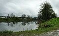 Subvilaĝa fiŝlago
 -
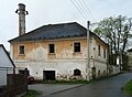 Konstruaĵo de eksa distilfarejo
 -
 Vilaĝplaco


| ||||
Content Disclaimer
Informasi ini disarikan dari Wikipedia dan disajikan kembali untuk tujuan edukasi. Konten tersedia di bawah lisensi CC BY-SA 3.0. Kami tidak bertanggung jawab atas ketidakakuratan data yang bersumber dari kontribusi publik tersebut.
- The information displayed on this website is sourced in part or in whole from Wikipedia and has been adapted for the purpose of restating it. We strive to provide accurate and relevant information, however:
- There is no guarantee of absolute accuracy. Wikipedia is an open, collaborative project that can be edited by anyone, so information is subject to change.
- It is not intended to constitute professional advice. The content displayed is for informational and educational purposes only. For important decisions (e.g., medical, legal, or financial), please consult a professional.
- Content copyright. Wikipedia is licensed under the Creative Commons Attribution-ShareAlike License (CC BY-SA). This means that content may be reused with appropriate attribution and shared under a similar license.
- Responsible use. Any risk arising from the use of information from this website is entirely the responsibility of the user.