Krašlovice
| Krašlovice | |
| municipo | |
 Vido al Krašlovice
| |
| Oficiala nomo: Krašlovice | |
| Ŝtato | |
|---|---|
| Regiono | Sudbohemia regiono |
| Distrikto | Distrikto Strakonice |
| Administra municipo | Vodňany |
| Historia regiono | Bohemio |
| Rivero | Blanice |
| Situo | Krašlovice |
| - alteco | 398 m s. m. |
| - koordinatoj | 49° 10′ 00″ N 14° 07′ 57″ O / 49.16667 °N, 14.13250 °O (mapo) |
| Areo | 5,3 km² (530 ha) |
| Loĝantaro | 163 (2025) |
| Denseco | 30,75 loĝ./km² |
| Baseno | Ĉeskobudejovica baseno |
| Unua skribmencio | 1262 |
| Horzono | MET (UTC+1) |
| - somera tempo | MET (UTC+2) |
| Poŝtkodo | 389 01 |
| NUTS 3 | CZ031 |
| NUTS 4 | CZ0316 |
| NUTS 5 | CZ0316 536806 |
| Katastraj teritorioj | 2 |
| Partoj de municipo | 2 |
| Bazaj setlejunuoj | 2 |
  Situo enkadre de Ĉeĥio
| |
| Retpaĝo: www.kraslovice.cz | |
Krašlovice estas municipo de Ĉeĥio situanta en distrikto Strakonice sur la maldekstra bordo de rivero Blanice netutaj 4 km nordokcidente de Vodňany. Vivas ĉi tie 163 loĝantoj (2025).
La najbaraj municipoj de la setlejo estas Vodňany, Bavorov kaj Skočice.
Historio
La unua skribmencio pri la vilaĝo devenas el la jaro 1262.
Loĝantaro
Evoluo de nombro de loĝantoj
La datoj devenas el datumbazo de Vikidatumoj
| Jaro | Loĝantoj |
|---|---|
| 1869 | 375 |
| 1880 | 359 |
| 1890 | 327 |
| 1900 | 338 |
| 1910 | 329 |
| 1921 | 318 |
| Jaro | Loĝantoj |
|---|---|
| 1930 | 325 |
| 1950 | 218 |
| 1961 | 195 |
| 1970 | 152 |
| 1980 | 177 |
| 1991 | 180 |
| Jaro | Loĝantoj |
|---|---|
| 2001 | 137 |
| 2011 | 149 |
| 2014 | 151 |
| 2016 | 160 |
| 2017 | 168 |
| 2018 | 160 |
| Jaro | Loĝantoj |
|---|---|
| 2019 | 163 |
| 2020 | 157 |
| 2021 | 141 |
| 2022 | 159 |
| 2023 | 198 |
| 2024 | 179 |
| Jaro | Loĝantoj |
|---|---|
| 2025 | 163 |
Partoj de municipo
Municipo Krašlovice konsistas el du partoj sur du katastraj teritorioj.
- Krašlovice (ankaŭ nomo de k. t.)
- Vitice (k. t. Vitice u Vodňan)
Pluaj fotoj
-
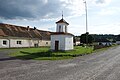 Kapelo en Krašlovice

| ||||
Content Disclaimer
Informasi ini disarikan dari Wikipedia dan disajikan kembali untuk tujuan edukasi. Konten tersedia di bawah lisensi CC BY-SA 3.0. Kami tidak bertanggung jawab atas ketidakakuratan data yang bersumber dari kontribusi publik tersebut.
- The information displayed on this website is sourced in part or in whole from Wikipedia and has been adapted for the purpose of restating it. We strive to provide accurate and relevant information, however:
- There is no guarantee of absolute accuracy. Wikipedia is an open, collaborative project that can be edited by anyone, so information is subject to change.
- It is not intended to constitute professional advice. The content displayed is for informational and educational purposes only. For important decisions (e.g., medical, legal, or financial), please consult a professional.
- Content copyright. Wikipedia is licensed under the Creative Commons Attribution-ShareAlike License (CC BY-SA). This means that content may be reused with appropriate attribution and shared under a similar license.
- Responsible use. Any risk arising from the use of information from this website is entirely the responsibility of the user.