Wikipedia:Graphics Lab/Map workshop
The Graphics Lab is a project to improve the graphical content of the Wikimedia projects. Requests for image improvements can be added to the workshop pages: Illustrations, Photographs and Maps. For questions or suggestions one can use the talk pages: Talk:Graphics Lab, Talk:Illustrations, Talk:Photographs and Talk:Maps.
This specific page is the requests page for the Map workshop. Anyone can make a request for a map to be created or improved for a Wikipedia article. The standard format for making a request is shown below, along with general advice, and should be followed. Many maps on the web are in the public domain. See c:Template:PD-map; no need to create another free map here if it already exists on the web. See this Casebook to see what maps qualify as public domain.
You are encouraged to share information and request advice from others. Also see possible conventions toolbox, map tutorials and topographic map tutorials.
| Advice to requesters |
|---|
|
What do we do?
|
.svg)


| If you have completed work and not received a reply you may use the {{GL Map reply}} template to inform the requester. |
| Map makers and other visitors to the Graphics Lab may be interested in the RSS feed of changes to this page. You may find it here. |
| See also our sister Map workshop at Commons and the WikiProject Maps |
| Result | Code | Usage |
|---|---|---|
{{resolved}} ~~~~
|
Mark a thread as resolved and request archiving | |
{{subst:bump}}
|
Delay automatic archiving of a section for 30 days | |
{{I take|~~~~}}
|
When you'll be working on the request | |
{{Done}} ~~~~
|
When the request is done |
This page is automatically archived by ClueBot III. | |
| This page has a backlog that requires the attention of willing editors. Please remove this notice when the backlog is cleared. |
Precolonial Zimbabwe trade routes

Could someone please do a more professional/less bastardised version of this map? It's for various articles such as Great Zimbabwe, History of Africa (7 in total). The source is Butua and the End of an Era (Van Waarden, 2012) page 50, I can email a screenshot of the page. Van Waarden's map has several other details, but it's just the ones included on this image that are necessary. Kowal2701 (talk, contribs) 14:06, 21 February 2026 (UTC)
 Bumping thread. Kowal2701 (talk, contribs) 19:01, 31 March 2026 (UTC)
- Bumping thread. Kowal2701 (talk, contribs) 22:07, 9 May 2026 (UTC)
SC Heritage Corridor: Discovery Route map + SC Heritage Corridor: Nature Route map
Need these for a page I am making, refer to making the map from here. TopG741 (talk) 21:58, 25 April 2026 (UTC)
Districts of Iraq
Hello wikipedians.
I would like for a vector version of commons:file:Iraq Dist.png, sure commons:file:Map of the districts of Iraq.svg but it was removed by this edit.
I believe that https://www.ecoi.net/en/file/local/1074303/1222_1190099310_iraq-governates-and-districts.pdf would be potentialy helpful in this case. Thanks in advance! GuesanLoyalist (talk) 23:25, 27 April 2026 (UTC)
- @Cmglee and WeaponizingArchitecture: would you be open to talking this request? GuesanLoyalist (talk) 02:12, 29 April 2026 (UTC)
- The SVG you linked were electoral districts used in 2021. ⛿ WeaponizingArchitecture | yell at me 03:17, 29 April 2026 (UTC)
- I added a move request for the SVG in question to something like "2021 electoral districts of Iraq.svg", would that be ok?
- Also, you didn't exactly answer on whether you wanted to do the request or not. Could you say it explicitly if you can? GuesanLoyalist (talk) 05:32, 29 April 2026 (UTC)
- @GuesanLoyalist: I'll pass on this job. Good luck! cmɢʟee τaʟκ (please add
{{ping|cmglee}}to your reply) 09:59, 29 April 2026 (UTC)- Really optional and all (like I wouldn't mind if you don't follow up a preference of mine) but would it be possible to do it in the style of the maps listed at commons:Category:SVG locator maps of provinces in Iraq (location map scheme) if you can? If you don't want to do it, then it's fine lol. GuesanLoyalist (talk) 11:14, 29 April 2026 (UTC)
- I do apologise for not saying this earlier, but I do have some other sources as well. Apologising as they might be brand new and make you restart your progress all over again.
- GuesanLoyalist (talk) 03:13, 3 May 2026 (UTC)
- The SVG you linked were electoral districts used in 2021. ⛿ WeaponizingArchitecture | yell at me 03:17, 29 April 2026 (UTC)
Tongan empire map update request

-
 Original version
 -
 Updated version


- Article(s)
- Tuʻi Tonga Empire
- Request
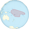
- The image before depicted the Tonga Empire as a behemoth the occupied almost all of the eastern pacific (https://upload.wikimedia.org/wikipedia/commons/b/bb/Map_of_the_of_Tu%27i_Tonga_Empire.svg) and it was changed to this newer and much more modest map (https://upload.wikimedia.org/wikipedia/commons/2/27/Tongan_Empire.png). However, the newer map is missing territories. The History of Tonga article states: "Their realm contained Wallis and Futuna, Tokelau, Tuvalu, Rotuma, Nauru, parts of Fiji, parts of the Solomon Islands, Kiribati, Niue, and parts of Samoa." Source provided is (https://books.google.com/books?id=0rE1vgAACAAJ)
Countries and places listed in the article that the map DOES contain: Samoa, Niue, Wallis and Futuna.
Countries and places listed in the article that the map DOES NOT contain: Tuvalu, Rotuma (part of Fiji), Nauru, Tokelau, parts of Kiribati.
I do not know how to make wikipedia maps. If there is any user here, of if the user who made the current map can update and add these territories, it would match the information on the history page and be historically accurate. -- ~2026-25870-40 (talk) 23:23, 29 April 2026 (UTC)
- Discussion
Map of the Province of Canada - 1841 to 1867
Hi,
Is there any way to get a simplified map of the old Province of Canada, which existed from 1841 to 1867? There are old original maps from the Victorian period, but they are not that easy to read, given their age and sepia colours (see the ones included in the Province of Canada article).
I'm thinking of something like this image, which is of Canada at Confederation: File:Canada 1867.svg
The pink and the blue portions together made up the Province of Canada immediately before Confederation. Could a map be made that just focuses on those two areas?
Also, would it be possible to put the cities of Quebec, Montreal, Kingston, Ottawa and Toronto on the proposed map? The reason is that I've recently completed an article on the political dispute over which of those cities should be seat of government for the Province of Canada. It would be very helpful to have a simplified, easy to follow map with those cities on it, for someone who is not familiar with Canadian geography:
Canadian seat of government dispute
If anyone is interested in this request, please ping me or leave a message on my Wikipedia Talk page to discuss.
Thanks for considering it.
Mr Serjeant Buzfuz (talk) 00:16, 5 May 2026 (UTC)
Maps for Battle of Leyte Gulf and Battle off Samar
Hello all,
This is a big project, but Commons:File:レイテ沖海戦図A3.svg and Commons:File:サマール沖海戦図3.svg are both superior to the maps we have at Battle off Samar and Battle of Leyte Gulf. An English translated version would be of much use.
Stikkyy (talk) 20:03, 8 May 2026 (UTC)
Update of the Roman catholic Diocese of Elblag map
-
 Current map of Elblag Diocese

- Article(s)
- Diocese of Elbląg
- Request
Hello ! Please update thus map of the Roman Catholic Diocese of Elblag:
- Create a new Tolkmicko Deanery by splitting the northern part of the Elblag Północ Deanery. The new Tolkimcko Deanery sholuld include these 6 parishes: Tolkmicko, Cieplice, Pogrodzie, Łęcze, Kadyny and Holy Family (Święta Rodzina) in Elbląg
- Rename Nadmorski Deanery to Krynica Morska Deanery
The current map is a JPG file. If possible please update it or convert it to SVG with the new changes
Please, leave a notification on my Polish talk page when the map is ready: -- KamilosR (talk) 08:39, 16 May 2026 (UTC)
- Discussion
Request
-
 Current map

Request to update Map of Leaders of Opposition in India
- File to be updated: File:Map of leaders of opposition in state legislative assemblies of India
- Specific changes required: Please update the coloring for the following three states:
- West Bengal: Recolor to the standard All India Trinamool Congress (AITC) green shade (such as hex code #24B44C). (Leader of Opposition: Sovandeb Chattopadhyay).
- Tamil Nadu: Recolor to the official Dravida Munnetra Kazhagam (DMK) black-and-red or standard DMK representative color (such as hex code #DD0000 or the existing DMK code used in Wikipedia infoboxes). (Leader of Opposition: Udhayanidhi Stalin).
- Kerala: Recolor to the standard CPI(M) / Left Front red shade (such as hex code #DE0000). (Leader of Opposition: Pinarayi Vijayan).
- Reason for change: To align the map with the current legislative environments resulting from assembly shifts and leadership appointments across West Bengal, Tamil Nadu, and Kerala.
- Sources proving the changes:
Thank you! ~2026-30045-86 (talk) 06:50, 20 May 2026 (UTC)
Creation of Map for Greater Bengaluru Authority and 2026 Greater Bengaluru Authority elections
Request: Maps for Greater Bengaluru Authority and its 5 corporations
Articles: 2026 Greater Bengaluru Authority elections, Greater Bengaluru Authority
Background: Bengaluru was previously governed by a single municipal body, BBMP, which has been dissolved and replaced by 5 city corporations under an apex body called the Greater Bengaluru Authority. Elections to these corporations are expected by August 2026.
Maps needed:
- (Priority) GBA boundary showing the 5 corporations — Bengaluru Central (63 wards), North (72), South (72), East (50), West (112)
- Same map with all 369 wards marked
- (Lower priority) Individual ward maps for each of the 5 corporations
Reference/boundary data: cityofficials.bengawalk.com · gba.karnataka.gov.in (Scroll down on the homepage to find the map) ~2026-23412-42 (talk) 07:35, 23 May 2026 (UTC)
Map of Fumba Town
- Article(s)
- Fumba Town
- Request
Hi all. I'm looking to create a map of the Fumba Town development, a free economic zone located on the southwestern end of Unguja, the largest island of Zanzibar. I can provide you with this map as a starter. Do note that this takes you to a Tanzanian government website, so tread lightly if you're from East Africa, I'm not entirely certain how their program works down there but I know it's not great. You can find the map on page 26. I can also point you towards this previous discussion that has way more info that I'm sure you'd find helpful if you chose to take up this request. It includes maps of the smallest administrative subdivisions of Tanzania and the Zanzibar islands. and might be helpful attempting to determine exact boundaries off of a grainy map.
I can promise a barnstar as thanks, and help with an article of your choosing if you'd like, but really not much more than that. You have my thanks in advance. CSGinger14 (talk) 22:15, 30 May 2026 (UTC)
-- CSGinger14 (talk) 22:15, 30 May 2026 (UTC)
- Discussion
- @CSGinger14: IMHO, Barnstars are meant to be awarded after the fact. Attempting to "bribe" someone with one might be counterproductive. cmɢʟee τaʟκ (please add
{{ping|cmglee}}to your reply) 14:45, 2 June 2026 (UTC)
Content Disclaimer
Informasi ini disarikan dari Wikipedia dan disajikan kembali untuk tujuan edukasi. Konten tersedia di bawah lisensi CC BY-SA 3.0. Kami tidak bertanggung jawab atas ketidakakuratan data yang bersumber dari kontribusi publik tersebut.
- The information displayed on this website is sourced in part or in whole from Wikipedia and has been adapted for the purpose of restating it. We strive to provide accurate and relevant information, however:
- There is no guarantee of absolute accuracy. Wikipedia is an open, collaborative project that can be edited by anyone, so information is subject to change.
- It is not intended to constitute professional advice. The content displayed is for informational and educational purposes only. For important decisions (e.g., medical, legal, or financial), please consult a professional.
- Content copyright. Wikipedia is licensed under the Creative Commons Attribution-ShareAlike License (CC BY-SA). This means that content may be reused with appropriate attribution and shared under a similar license.
- Responsible use. Any risk arising from the use of information from this website is entirely the responsibility of the user.