Predil Pass
| Predil Pass | |
|---|---|
 Pass road with Mount Mangart | |
| Elevation | 1,156 m (3,793 ft) |
| Location | Italy–Slovenia border |
| Coordinates | 46°25′7″N 13°34′47″E / 46.41861°N 13.57972°E |
 Predil Pass Location within the Alps | |
The Predil Pass, also known as the Predel Pass (Italian: Passo di Predil; Slovene: Predel, pronounced [pɾɛˈdeːl]; elevation 1,156 meters or 3,793 feet), is a high mountain pass on the border between Italy and Slovenia.
Geography

The pass is located in the Julian Alps, between the peaks of Mount Mangart to the north and Mount Kanin to the south. It connects Cave del Predil, part of the Italian municipality of Tarvisio in the northwest, with the Municipality of Bovec in the Upper Soča (Isonzo) Valley in Slovenia.
On the Italian side, state highway no. 54 (del Friuli) leads from Tarvisio and the Canal Valley along Slizza Creek to Lake Predil, where the route to the Sella Nevea Pass in the south branches off, and uphill to the Predil crest. On the Slovenian side, road no. 203 runs downhill to Log pod Mangartom and continues to Bovec. The village of Strmec na Predelu lies just below the border crossing.
History
The road was built from 1319 onwards by the citizens of Cividale in the Patriarchate of Aquileia with the consent of the Prince-Bishops of Bamberg, then the possessors of the Carinthian lands in the north. However, the importance of the trade route diminished after the Aquileia territory in the south was incorporated into the Domini di Terraferma by the Republic of Venice in 1420.
Since 1754 the Predil Pass marked the border between the Duchy of Carinthia with the lands of the Princely County of Gorizia and Gradisca (part of the Austrian Littoral from 1849) in the southeast, both part of the Habsburg monarchy. During the War of the Fifth Coalition, an Austrian contingent under Captain Johann Hermann von Hermannsdorf on 18 May 1809 fought against the French forces moving from the Kingdom of Italy upon the Battle of Tarvis. Hermannsdorf was killed in battle, in 1851 a memorial was erected in his honour.
In 1903 a 4.5 km (2.8 mi) long tunnel (Štoln) was built beneath the pass, serving miners from Log pod Mangartom on their way to the lead mines in Cave del Predil. In World War I the mine railway was used to supply the Austro-Hungarian Army in the Battles of the Isonzo against the Kingdom of Italy.
Gallery
-
 West view from the pass, showing Lake Predil
 -
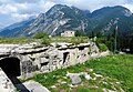 Fortification on the Italian side of the pass
 -
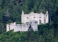 Austrian fort on the Slovenian side of the pass
 -
 Monument to troops killed at the pass in 1809
 -
 Grave of Austrian troops killed at the pass in 1809
 -
 Tunnel entrance in Log pod Mangartom


See also
External links
 Media related to Predil Pass at Wikimedia Commons
Content Disclaimer
Informasi ini disarikan dari Wikipedia dan disajikan kembali untuk tujuan edukasi. Konten tersedia di bawah lisensi CC BY-SA 3.0. Kami tidak bertanggung jawab atas ketidakakuratan data yang bersumber dari kontribusi publik tersebut.
- The information displayed on this website is sourced in part or in whole from Wikipedia and has been adapted for the purpose of restating it. We strive to provide accurate and relevant information, however:
- There is no guarantee of absolute accuracy. Wikipedia is an open, collaborative project that can be edited by anyone, so information is subject to change.
- It is not intended to constitute professional advice. The content displayed is for informational and educational purposes only. For important decisions (e.g., medical, legal, or financial), please consult a professional.
- Content copyright. Wikipedia is licensed under the Creative Commons Attribution-ShareAlike License (CC BY-SA). This means that content may be reused with appropriate attribution and shared under a similar license.
- Responsible use. Any risk arising from the use of information from this website is entirely the responsibility of the user.