Boundaries of the former Skagway-Yakutat-Angoon Census Area.
The census area was significantly larger in the 1990 census, at which time it was the Skagway–Yakutat–Angoon Census Area. After Yakutat was incorporated as a consolidated-city borough on September 22, 1992, it was renamed Skagway–Hoonah–Angoon Census Area;[4] When Skagway followed suit on June 20, 2007,[5][6] the census area assumed its current name.
Geography
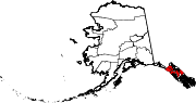
According to the U.S. Census Bureau, the census area has a total area of 10,914 square miles (28,270 km2), of which 7,525 square miles (19,490 km2) is land and 3,389 square miles (8,780 km2) (31.1%) is water.[7] A map showing its current boundaries is shown here:[8]
There were 1,369 households, out of which 30.80% had children under the age of 18 living with them, 49.30% were married couples living together, 8.40% had a female householder with no husband present, and 36.70% were non-families. 30.10% of all households were made up of individuals, and 5.60% had someone living alone who was 65 years of age or older. The average household size was 2.50 and the average family size was 3.14.
In the census area, the population was spread out, with 26.80% under the age of 18, 7.10% from 18 to 24, 29.50% from 25 to 44, 29.30% from 45 to 64, and 7.30% who were 65 years of age or older. The median age was 38 years. For every 100 females, there were 116.40 males. For every 100 females age 18 and over, there were 120.70 males.
Politics
One of the most Democratic areas in Alaska, the Hoonah-Angoon Census Area has only voted for a Republican for president once (during the 2000 election).
United States presidential election results for Hoonah-Angoon Census Area, Alaska[12]


.svg)