Hedel
Hedel | |
|---|---|
Town | |
 View from Hedel Bridge | |
_vlag.svg) Flag  Coat of arms | |
 Hedel Location in the province of Gelderland in the Netherlands  Hedel Hedel (Netherlands) | |
| Coordinates: 51°44′48″N 5°15′33″E / 51.74667°N 5.25917°E | |
| Country | Netherlands |
| Province | Gelderland |
| Municipality | Maasdriel |
| Area | |
• Total | 13.15 km2 (5.08 sq mi) |
| Elevation | 3.3 m (11 ft) |
| Population (2021)[1] | |
• Total | 5,095 |
| • Density | 387.5/km2 (1,003/sq mi) |
| Time zone | UTC+1 (CET) |
| • Summer (DST) | UTC+2 (CEST) |
| Postal code | 5321[1] |
| Dialing code | 073 |
| Major roads | A2, N831, Oude Rijksweg |
Hedel (Dutch pronunciation: [ˈɦeːdəl]) is a town in the Dutch province of Gelderland. It is a part of the municipality of Maasdriel, and lies about 7 km northwest of 's-Hertogenbosch.
Hedel was a separate municipality until 1999, when it was merged with Maasdriel.[3]
In World War II, there were a lot of fights in Hedel, especially during the month April 1945 when the armies of the Princess Irene Brigade came to liberate the town. Hedel has a very strategic location, it lies on the border of Gelderland and North Brabant and on the Maas. Almost the whole town of Hedel was destroyed during World War II.
A monument to 12 members of the Princess Irene Brigade killed between April 23rd and April 26th, 1945 was erected in Hedel.[4]
Hedel has its own harbour named 't Stik. There is also an excavation of the castle of Hedel. The excavations lie in the Historic Museum in Hedel. A clock Museum and a mini-zoo with snowy owls, goats, pheasants, parrots, chickens, ducks and other animals can also be found in Hedel.
Hedel has got both a Reformed and a Catholic church. The reformed church was built in 1640, but it was destroyed during World War II and rebuilt in the original style several years later.
On the first Monday of November after 1 November, there is a horse market. This is the biggest horse market in the Netherlands and one of the biggest horse markets in Europe.
Gallery
-
 Dutch Reformed church
 -
 Horse market
 -
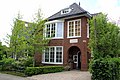 Villa in Hedel
 -
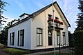 House in Hedel


References
- ^ a b c "Kerncijfers wijken en buurten 2021". Central Bureau of Statistics. Retrieved 13 April 2022.
- ^ "Postcodetool for 5321GA". Actueel Hoogtebestand Nederland (in Dutch). Het Waterschapshuis. 24 July 2019. Retrieved 13 April 2022.
- ^ Ad van der Meer and Onno Boonstra, "Repertorium van Nederlandse gemeenten", KNAW, 2006. "KNAW > Publicaties > Detailpagina". Archived from the original on 2007-02-20. Retrieved 2009-12-03.
- ^ "Monument Princess Irene Brigade Hedel - Hedel - TracesOfWar.com". www.tracesofwar.com.
External links
Content Disclaimer
Informasi ini disarikan dari Wikipedia dan disajikan kembali untuk tujuan edukasi. Konten tersedia di bawah lisensi CC BY-SA 3.0. Kami tidak bertanggung jawab atas ketidakakuratan data yang bersumber dari kontribusi publik tersebut.
- The information displayed on this website is sourced in part or in whole from Wikipedia and has been adapted for the purpose of restating it. We strive to provide accurate and relevant information, however:
- There is no guarantee of absolute accuracy. Wikipedia is an open, collaborative project that can be edited by anyone, so information is subject to change.
- It is not intended to constitute professional advice. The content displayed is for informational and educational purposes only. For important decisions (e.g., medical, legal, or financial), please consult a professional.
- Content copyright. Wikipedia is licensed under the Creative Commons Attribution-ShareAlike License (CC BY-SA). This means that content may be reused with appropriate attribution and shared under a similar license.
- Responsible use. Any risk arising from the use of information from this website is entirely the responsibility of the user.