Share to: share facebook share twitter share wa share telegram print page


Hailles

Hailles
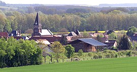
A general view of Hailles
Location of Hailles
Map
Hailles is located in France
Hailles
Hailles
Hailles is located in Hauts-de-France
Hailles
Hailles
Coordinates: 49°48′22″N 2°26′23″E / 49.8061°N 2.4397°E / 49.8061; 2.4397
CountryFrance
RegionHauts-de-France
DepartmentSomme
ArrondissementMontdidier
CantonMoreuil
IntercommunalityCC Avre Luce Noye
Government
 • Mayor (2020–2026) Fabrice Veront[1]
Area
1
5.07 km2 (1.96 sq mi)
Population
 (2021)[2]
413
 • Density81/km2 (210/sq mi)
Time zoneUTC+01:00 (CET)
 • Summer (DST)UTC+02:00 (CEST)
INSEE/Postal code
80405 /80440
Elevation32–110 m (105–361 ft)
(avg. 35 m or 115 ft)
1 French Land Register data, which excludes lakes, ponds, glaciers > 1 km2 (0.386 sq mi or 247 acres) and river estuaries.

Hailles (French pronunciation: [aj]) is a commune in the Somme department in Hauts-de-France in northern France.

Geography

Hailles is situated on the banks of the river Avre and by the D90e road, some 10 miles (16 km) southeast of Amiens.

History

The name probably comes from ‘haie’ (eng: hedge), and has been variously written as Haies or Heilles. During the Franco-Prussian War of 1870, some francs-tireurs, hidden behind the town fired 60 times on a Prussian officer. All missed, he wasn't even scratched. The German troops threatened to burn down the town.

Population

Historical population
YearPop.±% p.a.
1793 244—    
1800 300+3.00%
1806 322+1.19%
1821 356+0.67%
1831 368+0.33%
1836 372+0.22%
1841 405+1.71%
1846 470+3.02%
1851 460−0.43%
1856 420−1.80%
1861 416−0.19%
1866 389−1.33%
1872 373−0.70%
1876 372−0.07%
1881 369−0.16%
1886 325−2.51%
1891 336+0.67%
1896 323−0.79%
YearPop.±% p.a.
1901 268−3.66%
1906 252−1.22%
1911 253+0.08%
1921 152−4.97%
1926 181+3.55%
1931 183+0.22%
1936 201+1.89%
1946 214+0.63%
1954 209−0.30%
1962 226+0.98%
1968 236+0.72%
1975 219−1.06%
1982 263+2.65%
1990 319+2.44%
1999 332+0.44%
2007 426+3.17%
2012 429+0.14%
2017 422−0.33%
Source: EHESS[3] and INSEE (1968-2017)[4]

See also

References

  1. ^ "Répertoire national des élus: les maires". data.gouv.fr, Plateforme ouverte des données publiques françaises (in French). 2 December 2020.
  2. ^ "Populations légales 2021" (in French). The National Institute of Statistics and Economic Studies. 28 December 2023.
  3. ^ Des villages de Cassini aux communes d'aujourd'hui: Commune data sheet Hailles, EHESS (in French).
  4. ^ Population en historique depuis 1968, INSEE


Kembali kehalaman sebelumnya