Durmitor Ring
| Durmitor Ring | |
|---|---|
 | |
| Route information | |
| Length | 76 km (47 mi) |
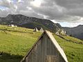
The Durmitor Ring (Serbo-Croatian: Durmitorski Prsten) is a scenic mountain road loop in northern Montenegro, encircling parts of the Durmitor massif. It is designated as one of Montenegro's official "Panoramic Roads".[1]
Route description
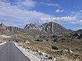
The 76-kilometer (47-mile) loop begins and ends in the town of Žabljak, the highest town in the Balkans and the main gateway to Durmitor National Park.mThe road is fully paved but narrow, winding, and features steep inclines and descents, reaching a maximum elevation of approximately 1,950 meters (6,400 feet) at the Štuoc mountain pass.[1][2][3]
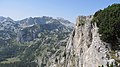
Key viewpoints and landmarks along the route include: the villages of Mala Crna Gora, Trsa, and Pišče; peaks like Ćurevac, Prutaš and Savin Kuk; mountains including Crvena Greda and Sedlena Greda; valleys like Tara River Canyon, Sušica Canyon and Pošćenska Valley, and crosses Sedlo Pass, the highest road pass in Montenegro at 1,907 meters.[1][2][3]
Tourism and access
The road is primarily used for sightseeing and provides access to trailheads for hikes to peaks such as Bobotov Kuk, Prutaš, and Sedlena Greda. It is considered a difficult route for mountain biking, with 76 km of distance and significant elevation gain.[1][2][3]
The recommended time to travel is between late May and October, as winter snow closes the road. The standard direction of travel is counter-clockwise, though the clockwise direction is recommended for campervans. The route is not suitable for large campers or vehicles longer than 7 meters and the only fuel station along the route is in Žabljak.[1][3]
Gallery
-
-
 Čurevac Viewpoint of Tara River Canyon
 -
-
-

-

-

-

-

-


.jpg)


References
- ^ a b c d e "Durmitor Ring: the Most Scenic Drive in Montenegro". lifeontheroam.com. Retrieved 2025-12-22.
- ^ a b c "Durmitorski prsten". wikiloc.com. Retrieved 2025-12-22.
- ^ a b c d "Durmitorski prsten - Panoramski Putevi" (PDF). montenegro.travel (in Serbian). Retrieved 2025-12-22.
Content Disclaimer
Informasi ini disarikan dari Wikipedia dan disajikan kembali untuk tujuan edukasi. Konten tersedia di bawah lisensi CC BY-SA 3.0. Kami tidak bertanggung jawab atas ketidakakuratan data yang bersumber dari kontribusi publik tersebut.
- The information displayed on this website is sourced in part or in whole from Wikipedia and has been adapted for the purpose of restating it. We strive to provide accurate and relevant information, however:
- There is no guarantee of absolute accuracy. Wikipedia is an open, collaborative project that can be edited by anyone, so information is subject to change.
- It is not intended to constitute professional advice. The content displayed is for informational and educational purposes only. For important decisions (e.g., medical, legal, or financial), please consult a professional.
- Content copyright. Wikipedia is licensed under the Creative Commons Attribution-ShareAlike License (CC BY-SA). This means that content may be reused with appropriate attribution and shared under a similar license.
- Responsible use. Any risk arising from the use of information from this website is entirely the responsibility of the user.