Utupua
| Utupua
| ||
|---|---|---|
 | ||
| Gewässer | Pazifischer Ozean | |
| Inselgruppe | Santa-Cruz-Inseln | |
| Geographische Lage | 11° 16′ S, 166° 31′ O | |
| ||
| Länge | 14 km | |
| Breite | 10 km | |
| Fläche | 69 km² | |
| Höchste Erhebung | Mount Royal (Mt Rautahnimba) 378 m | |
| Einwohner | 1168 (2009) 17 Einw./km² | |
| Hauptort | Nembao | |
 | ||


Utupua, auch Tapoua oder Lord Edgecombe Island, ist eine Insel der Santa-Cruz-Inseln des Inselstaats der Salomonen. Die 378 Meter hohe Insel liegt zwischen Vanikoro und Santa Cruz. Die Insel ist vollständig von einem Korallenriff umgeben.
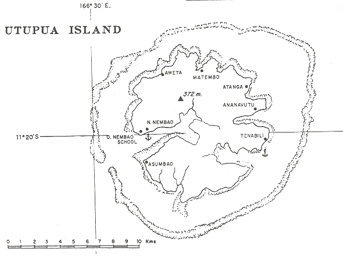
2009 lebten 1168 Menschen auf Utupua, die sich auf verschiedene kleine Dörfer verteilten. Die wichtigsten Dörfer sind Nembao (Hauptort, an der Nordseite der Einfahrt des Basilisk Harbour im Westen der Insel gelegen), Avita, Malombo, Tanimbili (Tanabili), Apakho (Apakhö) und Asimboa. Administrativ gehört die Insel zur Provinz Temotu.
Utupua ist eine von nur drei Inseln, auf der noch die Santa-Cruz-Taube vorkommt, eine Taubenart, die von der IUCN als stark gefährdet eingeordnet wird.[1]
Geschichte
Die erste Sichtung durch Europäer erfolgte im September 1595 durch die zweite spanische Expedition von Álvaro de Mendaña. Genauer gesagt wurde es von Lorenzo Barreto gesichtet, als er das Kommando über eines der kleineren Schiffe auf einer lokalen Reise um die damals Santa Cruz genannte Insel hatte, die heute die Nendö-Insel ist.[2][3]
Laut YouTuber Luke Korns wird auf Utupua immer noch ein traditionelles System verwendet, bei dem alle Bewohner ihr Eigentum teilen, anstatt ein Tausch- oder Geldsystem zu verwenden.[4]
Belege
- ↑ Factsheet auf BirdLife International
- ↑ Sharp, Andrew The discovery of the Pacific Islands Oxford, 1960, S. 52–55.
- ↑ Brand, Donald D. The Pacific Basin: A History of its Geographical Explorations The American Geographical Society, New York, 1967, S. 136.
- ↑ I Visited the Island that Capitalism Never Reached (no money used here). In: Youtube.com. Abgerufen am 19. Juni 2024.
Weblinks

- Utupua Island, Solomon Islands (Internet-Archiv) ( vom 7. Februar 2012 im Internet Archive)
- Kartenskizze von Utupua
Content Disclaimer
Informasi ini disarikan dari Wikipedia dan disajikan kembali untuk tujuan edukasi. Konten tersedia di bawah lisensi CC BY-SA 3.0. Kami tidak bertanggung jawab atas ketidakakuratan data yang bersumber dari kontribusi publik tersebut.
- The information displayed on this website is sourced in part or in whole from Wikipedia and has been adapted for the purpose of restating it. We strive to provide accurate and relevant information, however:
- There is no guarantee of absolute accuracy. Wikipedia is an open, collaborative project that can be edited by anyone, so information is subject to change.
- It is not intended to constitute professional advice. The content displayed is for informational and educational purposes only. For important decisions (e.g., medical, legal, or financial), please consult a professional.
- Content copyright. Wikipedia is licensed under the Creative Commons Attribution-ShareAlike License (CC BY-SA). This means that content may be reused with appropriate attribution and shared under a similar license.
- Responsible use. Any risk arising from the use of information from this website is entirely the responsibility of the user.