Hoffmann-Insel
| Hoffmann-Insel
| ||
|---|---|---|
 | ||
| Gewässer | Arktischer Ozean | |
| Inselgruppe | Franz-Josef-Land | |
| Geographische Lage | 81° 17′ N, 60° 12′ O | |
| ||
| Länge | 13 km | |
| Breite | 5,6 km | |
| Fläche | 49 km² | |
| Höchste Erhebung | 64 m | |
| Einwohner | unbewohnt | |
 | ||


Die Hoffmann-Insel (russisch Остров Гофмана, Ostrov Gofmana, teilweise auch als Hofmann-Insel bekannt) ist eine unbewohnte Insel des Franz-Josef-Lands, Oblast Archangelsk, Russland. Sie wurde nach dem Baron Freiherr Leopold von Hoffmann, einem Mitglied der österreichisch-ungarischen Nordpolgesellschaft, benannt.[1][2]
Geographie
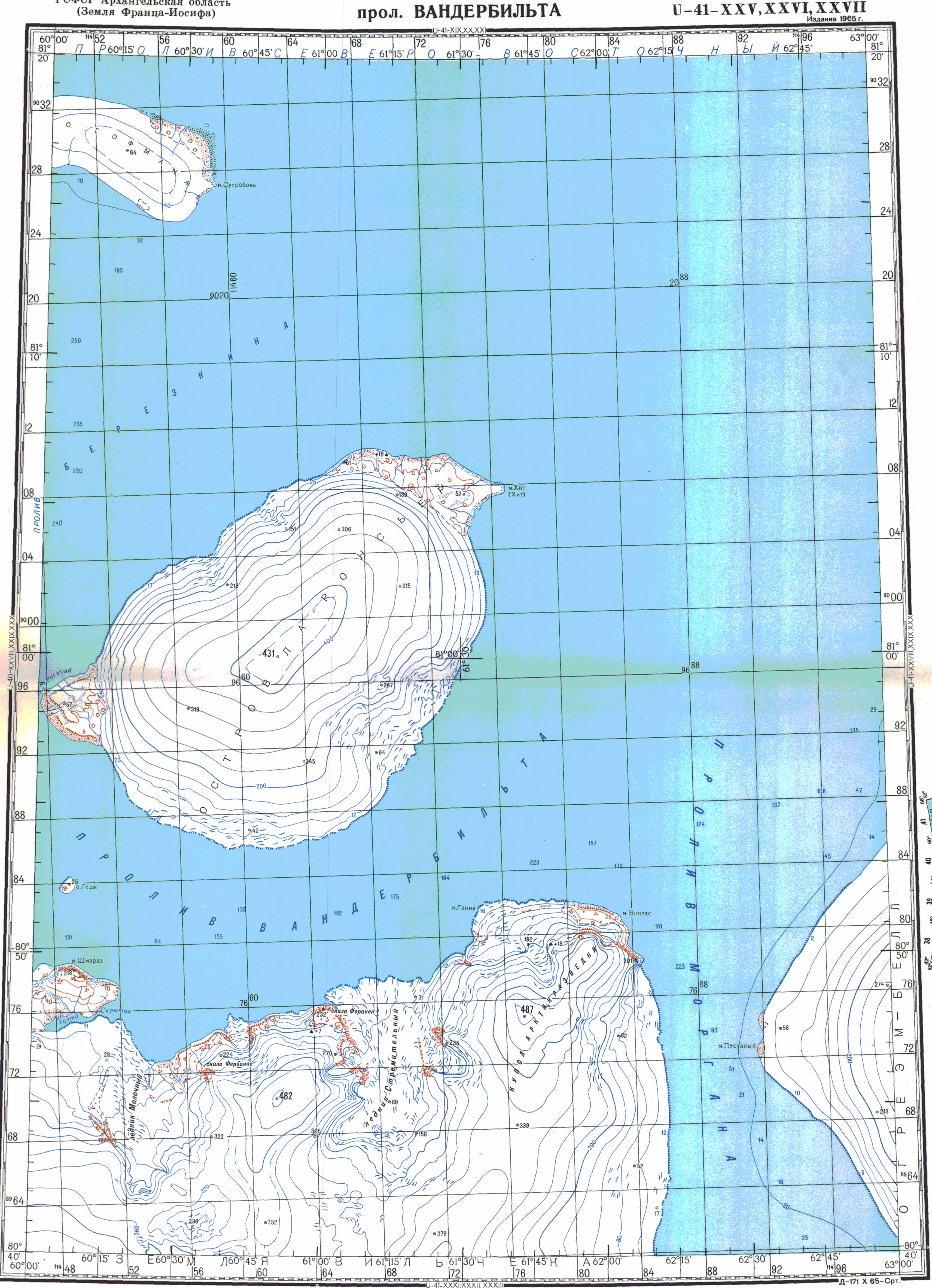
Die Hoffmann-Insel weist bei einer Fläche von ca. 49 km² eine Länge von 13 km und eine maximale Breite von 5,6 km auf.[3] Sie liegt ca. 9 km östlich der Rainer-Insel, von der sie durch die Ruslan-Straße (Proliw Ruslan) getrennt ist.[3] Drei kleine Inselchen liegen vor ihrer nordöstlichen Küste.[3] Nordöstlich der Hoffmann-Insel verläuft ein 45 km breiter Kanal, bekannt als Proliw Sewero Wostotschny, auf dessen Gegenseite die Freeden-Insel liegt.[3] Ihre höchste Erhebung misst 64 m.[4]
Weblinks
- Topographische Karte U41-XXV-XXVI-XXVII Proliw Wanderbilta im Maßstab 1:200.000
Einzelnachweise
- ↑ Günther Hamann: Das Zeitalter Kaiser Franz Josefs im Spiegel der Topographie des Franz-Josefs-Landes. In: Publikationen aus dem Archiv der Universität Graz. Band 4, 1975, S. 139–151, hier: S. 146 (eingeschränkte Vorschau in der Google-Buchsuche)
- ↑ Johan Schimanski, Ulrike Spring: Passagiere des Eises: Polarhelden und arktische Diskurse 1874. Böhlau Verlag, Wien 2015, ISBN 978-3-205-79606-0, S. 102 (eingeschränkte Vorschau in der Google-Buchsuche).
- ↑ a b c d Messung von Länge, Breite und Fläche über Google Maps
- ↑ Topographische Karte U41-XXV-XXVI-XXVII im Maßstab 1:200.000

Aagaard-Insel | Adelaide-Insel | Alexandraland | Alger-Insel | Apollonow-Insel | Arthur-Insel | Becker-Insel | Bell-Insel | Berghaus-Insel | Bliss-Insel | Borisjak-Insel | Brady-Insel | Brosch-Insel | Brice-Insel | Bromwich-Insel | Brown-Inseln | Bruce-Insel | Champ-Insel | Coburg-Insel | David-Insel | Davis-Insel | Derewjanny-Insel | Dicks-Insel | Eaton-Insel | Etheridge-Inseln | Elizabeth-Insel | Eva-Liv-Insel | Freeden-Insel | Geddes-Insel | Gorbunow-Insel | Graham-Bell-Insel | Greely-Insel | Hall-Insel | Harley-Insel | Hayes-Insel | Hochstetter-Inseln | Hoffmann-Insel | Hohenlohe-Insel | Hooker-Insel | Houen-Insel | Iwanow-Insel | Jackson-Insel | Jefferson-Insel | Kane-Insel | Karl-Alexander-Insel | Klagenfurt-Insel | Kling-Insel | Knospe-Insel | Koettlitz-Insel | Koldewey-Insel | Komsomol-Inseln | Kupolok-Insel | Kutschin-Inseln | Kuhn-Insel | La-Ronciere-Insel | Lamont-Insel | Leigh-Smith-Insel | Lewanewski-Insel | Luigi-Insel | Lütke-Insel | Mabel-Insel | MacGee-Inseln | May-Insel | Maly-Insel | Marley-Insel | Mathilda-Insel | McClintock-Insel | McNulty-Insel | Nansen-Insel | Newcomb-Insel | Newton-Insel | Nitsch-Insel | Northbrook-Insel | Nowy-Insel | Ommanney-Insel | Payer-Insel | Perlmutt-Insel | Pontremoli-Inseln | Prinz-Georg-Land | Querini-Insel | Rainer-Insel | Robinson-Insel | Royal-Society-Insel | Rudolf-Insel | Salisbury-Insel | Salm-Insel | Schönau-Insel | Scott-Keltie-Insel | Solowjow-Insel | Stoliczka-Insel | Sub-Insel | Tillo-Insel | Torup-Insel | Tom-Insel | Trjochlutschewoi-Insel | Tschitschagow-Inseln | Udatschny-Insel | Ugolnoi-Kopi-Insel | Weyprecht-Insel | Windward-Insel | Wiener-Neustadt-Insel | Wilczek-Insel | Wilczekland | Ziegler-Insel
Content Disclaimer
Informasi ini disarikan dari Wikipedia dan disajikan kembali untuk tujuan edukasi. Konten tersedia di bawah lisensi CC BY-SA 3.0. Kami tidak bertanggung jawab atas ketidakakuratan data yang bersumber dari kontribusi publik tersebut.
- The information displayed on this website is sourced in part or in whole from Wikipedia and has been adapted for the purpose of restating it. We strive to provide accurate and relevant information, however:
- There is no guarantee of absolute accuracy. Wikipedia is an open, collaborative project that can be edited by anyone, so information is subject to change.
- It is not intended to constitute professional advice. The content displayed is for informational and educational purposes only. For important decisions (e.g., medical, legal, or financial), please consult a professional.
- Content copyright. Wikipedia is licensed under the Creative Commons Attribution-ShareAlike License (CC BY-SA). This means that content may be reused with appropriate attribution and shared under a similar license.
- Responsible use. Any risk arising from the use of information from this website is entirely the responsibility of the user.