Niedersept
| Sept | |
 | |
| Verwàltung | |
|---|---|
| Land | |
| Region | |
| Département | Haut-Rhin (68) |
| Arrondissement | Altkirch |
| Kànton | Màsmìnschter |
| Kommünàlverbànd | Sud Alsace Largue |
| Àmtliga Nàma | Seppois-le-Bas |
| Maire | Maurice Barnabe (2014-2020)[1] |
| Code Insee | 68305 |
| Poschtlaitzàhl | 68580 |
| Iiwohner | |
| Iiwohner | 1.443 |
| Flech | 6,73 km2 |
| Bevelkerungsdicht | 196,14 Iiw./km2 |
| Làg | |
| Koordinate | 47° 32′ 11″ N, 7° 10′ 28″ E / 47.536388888889°N,7.1744444444444°EKoordinate: 47° 32′ 11″ N, 7° 10′ 28″ E / 47.536388888889°N,7.1744444444444°E |
| Heche | 395 m |
 Sept Sept (Frànkrich) | |
| Website | |
| http://seppoislebas.fr | |
| Dialäkt: Elsassisch |
Sept (frz. Seppois-le-Bas, dt. Niedersept) ìsch e frànzeesche Gmein ìm Owerelsàss ìn dr Region Grand Est (bìs 2015 Region Elsàss). D Gmein ghert zem Kanton Màsmìnschter un zem Arrondissement Altkirch.
Geogràfi
Sept lijt ìm Sundgöi ìm Dàl vun dr Làrg àn dr Granz züe dr Franche-Comté. Nochbergmeine vun Sept sìn Ìwerstrooss ìm Nordweschte, Làrgìtze ìm Nordoschte, Obersept ìm Sìdoschte, Pfatterhüse ìm Sìde un Réchésy ìm Sìdweschte.
Gschìcht
Sept ìsch zem erschte Mol gnannt worre ànne 1236 àls Sepite (1256 Sape, 1257 Sapoi, 1269 Septe, 1302 Septen inferioris, 1793 Nidersept).
Vun 1871 bìs 1918 hàt d Gmein zem ditsche Richslànd Elsàss-Lothringe ghert.
Verwàltung
Dr Maire vun Sept ìsch dr Maurice Barnabe. Sept ghert zem Kommünàlverbànd Sud Alsace Largue.
Bevelkerungsentwìcklung
| Johr | 1962 | 1968 | 1975 | 1982 | 1990 | 1999 | 2007 |
| Inwohner[2] | 539 | 560 | 645 | 638 | 836 | 946 | 1080 |
Verkehr
Vun 1910 bis 1971 hàt s z Sept e Bàhnhof gan àn dr Bàhnlinie Dàmmerkìlch–Pfatterhüse.
Dialekt
Dr elsassisch Dialekt vun Sept ghert zem Owerrhinàlemànnisch.
-
 Kìrich St. Mauritius
 -
 d kàpüt Kìrich ànne 1916
 -
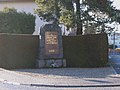
 Monument du char Assas
 -
 Monument du GMA
 -
 Monument du RICM


Literàtür
- Michel Paul Urban: Lieux dits. Dictionnaire étymologique et historique des noms de lieux en Alsace. Édition du Rhin, Strasbourg 2003
Weblink
 Commons: Seppois-le-Bas – Sammlig vo Multimediadateie
Referanza
- ↑ Liste des maires au 25 avril 2014 (data.gouv.fr)
- ↑ INSEE: Population et logements par commune depuis le recensement de 1962 (1961 pour les Dom) à 1999
Content Disclaimer
Informasi ini disarikan dari Wikipedia dan disajikan kembali untuk tujuan edukasi. Konten tersedia di bawah lisensi CC BY-SA 3.0. Kami tidak bertanggung jawab atas ketidakakuratan data yang bersumber dari kontribusi publik tersebut.
- The information displayed on this website is sourced in part or in whole from Wikipedia and has been adapted for the purpose of restating it. We strive to provide accurate and relevant information, however:
- There is no guarantee of absolute accuracy. Wikipedia is an open, collaborative project that can be edited by anyone, so information is subject to change.
- It is not intended to constitute professional advice. The content displayed is for informational and educational purposes only. For important decisions (e.g., medical, legal, or financial), please consult a professional.
- Content copyright. Wikipedia is licensed under the Creative Commons Attribution-ShareAlike License (CC BY-SA). This means that content may be reused with appropriate attribution and shared under a similar license.
- Responsible use. Any risk arising from the use of information from this website is entirely the responsibility of the user.