|
バリト川
Barito River
Sungai Barito, Sungai Dusun, Soengai Doesoen, Sungi Banjer, Sungi Dunsun, Soengai Baritoe, Sungai Banjar, Sungai Banjarmasin, Sungai Banjar Besar |
|---|
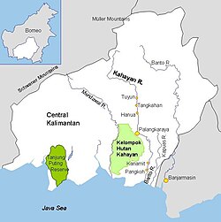
 Barito and other rivers in Central and South Kalimantan |
Location of river mouth カリマンタン島の地図を表示バリト川 (インドネシア) インドネシアの地図を表示 | | 所在 |
|---|
| 国 |
インドネシア |
|---|
| 特性 |
|---|
|
| | 水源 |
|
|---|
| • 所在地 |
ミュラー山脈(英語版) |
|---|
| 河口・合流先 |
|
|---|
• 所在地 |
ジャワ海 |
|---|
• 座標 |
南緯3度30分55秒 東経114度29分28秒 / 南緯3.51528度 東経114.49111度 / -3.51528; 114.49111 |
|---|
• 標高 |
0 m (0 ft) |
|---|
| 延長 |
1,090 km (680 mi) |
|---|
| 流域面積 |
81,675 km2 (31,535 sq mi)[1] |
|---|
| 川幅 |
|
|---|
| • 最小 |
300 m (980 ft) |
|---|
| • 平均 |
650 m (2,130 ft) to 1,000 m (3,300 ft) |
|---|
| • 最大 |
2,000 m (6,600 ft) |
|---|
| 水深 |
|
|---|
| • 最小 |
3 m (9.8 ft) |
|---|
| • 平均 |
7 m (23 ft) to 8 m (26 ft) |
|---|
| • 最大 |
25 m (82 ft) |
|---|
|
| | 流量 |
|
|---|
| • 観測地点 |
Barito Delta, ジャワ海, インドネシア, ボルネオ島 (カリマンタン) |
|---|
| • 平均 |
(Period: 2008–2015)5,497 m3/s (194,100 cu ft/s)[1]
(Period of data: 2003–2016)4,514 m3/s (159,400 cu ft/s)[2]
(Period: 1970–2000)129 km3/a (4,100 m3/s)[3] |
|---|
| • 最大 |
27,000 m3/s (950,000 cu ft/s) |
|---|
|
| | 流量 |
|
|---|
| • 観測地点 |
バンジャルマシン (Basin size: 61,582 km2 (23,777 sq mi) |
|---|
| • 平均 |
(Period of data: 2006–2011)4,502 m3/s (159,000 cu ft/s)[4] |
|---|
|
| | 流量 |
|
|---|
| • 観測地点 |
Barito–Kapuas–Kahayan Delta (Basin size: 98,500 km2 (38,000 sq mi) |
|---|
| • 平均 |
7,000 m3/s (250,000 cu ft/s) |
|---|
| 流域 |
|---|
| 水系 |
Barito basin (DAS330363)[5] |
|---|
| 主な支流 |
|
|---|
| • 左岸 |
Mangkatip, ネガラ川(英語版), Martapura River |
|---|
| • 右岸 |
Murung River, Anjir Tamban, Anjir Serapat, Kapuas River (Barito River tributary)[6] |
|---|
Barito River in Kalimantan バリト川 (Barito river) は、インドネシアのカリマンタン島南部に位置する、長さ890kmの川。ミュラー山脈に発し、南へ流れてジャワ海へ注ぐ。この地方の中心都市であるバンジャルマシンを通っている。
脚注
- ^ a b (インドネシア語) Strategi & Kebijakan Pengelolaan Wilayah Sungai Barito - Kapuas dalam Rangka Mendukung Pengembangan Kawasan Perkotaan yang Berkelanjutan (Slide deck), https://id.scribd.com/doc/211844751
- ^ Ting-Hsuan, Huang; Chen-Tung, Arthur Chen; Hsiao-Chun, Tseng; Jiann-Yuh, Lou; Shu Lun, Wang; Liyang, Yang; Selvaraj, Kandasamy; Xuelu, Gao et al. (May 2017). “Riverine carbon fluxes to the South China Sea: Riverine carbon fluxes to the SCS”. Journal of Geophysical Research: Biogeosciences 122 (5): 1239–1259. doi:10.1002/2016JG003701. https://www.researchgate.net/publication/317140380.
- ^ Djoko, Suwarno; Ansje, Löhr; Carolien, Kroeze; Budi, Widianarko (2013). “Past and future trends in nutrient export by 19 rivers to the coastal waters of Indonesia”. Journal of Integrative Environmental Sciences 10 (1): 55-71. doi:10.1080/1943815X.2013.772902. https://doi.org/10.1080/1943815X.2013.772902.
- ^ Daniel, Stapper (2011). Artisanal gold mining, mercury and sediment in Central Kalimantan, Indonesia (MS thesis). University of Victoria (Canada). hdl:1828/3711。
- ^ Hukum Online. “Keputusan Menteri Kehutanan No. SK.511/MENHUT-V/2011” (インドネシア語). Template:Cite webの呼び出しエラー:引数 accessdate は必須です。
- ^ M. K. Adamy (2 April 2012). “Sungai Barito Potensi Alam yang Diabaikan” (インドネシア語). Pemerintah Provinsi Kalimantan Tengah. 2017年5月16日時点のオリジナルよりアーカイブ。2019年1月8日閲覧。
ウィキメディア・コモンズには、 バリト川に関連するカテゴリがあります。
座標: 南緯3度22分32秒 東経114度14分13秒 / 南緯3.37556度 東経114.23694度 / -3.37556; 114.23694
|