Share to: share facebook share twitter share wa share telegram print page


Vincent, Ohio

Vincent, Ohio
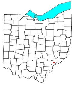
Location of Vincent, Ohio
Coordinates: 39°22′34″N 81°40′11″W / 39.37611°N 81.66972°W / 39.37611; -81.66972
CountryUnited States
StateOhio
CountyWashington
TownshipBarlow
Elevation764 ft (233 m)
Population
 • Total
329
Time zoneUTC-5 (Eastern (EST))
 • Summer (DST)UTC-4 (EDT)
ZIP code
45784
GNIS feature ID2628983[1]

Vincent is a census-designated place in southern Barlow Township, Washington County, Ohio, United States. It lies along State Route 339 near Tupper Creek, a subsidiary of the Little Hocking River, which in turn meets the Ohio River at Little Hocking to the south.[3] The population was 329 at the 2020 census.

History

Vincent had its start when the Marietta & Cincinnati Railroad was extended to that point.[4] The community was founded as Vincents Station in 1853 by Henry Earle Vincent, and named for him.[5] A post office called Vincent has been in operation since 1857.[6]

Education

References

  1. ^ a b U.S. Geological Survey Geographic Names Information System: Vincent, Ohio
  2. ^ "Vincent CPD, Ohio - Census Bureau Profile". United States Census Bureau. Retrieved September 10, 2023.
  3. ^ DeLorme, Ohio Atlas & Gazetteer, 7th ed., 2004, p. 81 ISBN 0-89933-281-1
  4. ^ "How communities got their names". Marietta Times. February 19, 2013. Retrieved December 29, 2015.
  5. ^ History of Washington County, Ohio: With Illustrations and Biographical Sketches. H.Z. Williams. 1881. p. 719.
  6. ^ "Washington County". Jim Forte Postal History. Retrieved December 29, 2015.


Kembali kehalaman sebelumnya