Share to: share facebook share twitter share wa share telegram print page


Varenne-Saint-Germain

Varenne-Saint-Germain
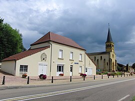
The town hall in Varenne-Saint-Germain
Location of Varenne-Saint-Germain
Map
Varenne-Saint-Germain is located in France
Varenne-Saint-Germain
Varenne-Saint-Germain is located in Bourgogne-Franche-Comté
Varenne-Saint-Germain
Coordinates: 46°25′47″N 4°01′34″E / 46.4297°N 4.0261°E / 46.4297; 4.0261
CountryFrance
RegionBourgogne-Franche-Comté
DepartmentSaône-et-Loire
ArrondissementCharolles
CantonDigoin
Area
1
15.62 km2 (6.03 sq mi)
Population
 (2021)[1]
703
 • Density45/km2 (120/sq mi)
Time zoneUTC+01:00 (CET)
 • Summer (DST)UTC+02:00 (CEST)
INSEE/Postal code
71557 /71600
Elevation227–278 m (745–912 ft)
(avg. 240 m or 790 ft)
1 French Land Register data, which excludes lakes, ponds, glaciers > 1 km2 (0.386 sq mi or 247 acres) and river estuaries.

Varenne-Saint-Germain (French pronunciation: [vaʁɛn sɛ̃ ʒɛʁmɛ̃]) is a commune in the Saône-et-Loire department in the region of Bourgogne-Franche-Comté in eastern France.

Geography

Varenne-Saint-Germain is bordered by the Digoin commune to the north, Vitry-en-Charollais to the east, Saint-Yan to the south and Chassenard to the west. The Arconce flows north-northwest through the middle of the commune, then flows into the Loire, which forms parts of the commune's western border.

History

In 1793, during the French Revolution, Reuillon, hamlet of Varennes-Reuillon, was renamed to La Montagne.[2] During the Second World War, the commune was crossed by the demarcation line; the remains of a border post are still present on the road D982. The commune of Varenne-Saint-Germain was created in 1973 by merging the communes of Saint-Germain-des-Rives and Varenne-Reuillon.

Demographics

In 2018, the commune had 718 inhabitants, an increase of 5.43% compared to 2013.

Sights

  • Château de Pontamailly, former property of Nicolas du Bessey de Contenson (who had bought the barony of Pontamailly in 1771). The remains of the castle were largely rebuilt in 1875.[3]
  • La Motte-Reuillon castle mound, whose central platform measures about 30 meters in diameter and where the remains of a tower remain.[4]

See also

References

  1. ^ "Populations légales 2021" (in French). The National Institute of Statistics and Economic Studies. 28 December 2023.
  2. ^ E. Lauxeur, Les changements de noms des communes de Saône-et-Loire pendant la Révolution, article published in the review "Images de Saône-et-Loire" No. 4, April 1970, pages 9-13.
  3. ^ Paul Chaussard, Au secours des Américains, article published in the review "Images de Saône-et-Loire" No. 135, September 2003, pages 21-23
  4. ^ Paul Chaussard, À propos de mottes féodales en pays digoinais, article published in the review "Images de Saône-et-Loire" No. 65, 1986, pages 3-7


Kembali kehalaman sebelumnya