Share to: share facebook share twitter share wa share telegram print page


River Bollin

River Bollin
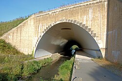
The River Bollin flows beneath the southern runway of Manchester Airport in this tunnel
The River Bollin and its tributaries within its catchment area. The direction of flow is east to west. Also shown is the sub-catchment area of the River Dean.
Location
CountryEngland
CountiesCheshire, Greater Manchester
Physical characteristics
Source 
 • locationMacclesfield Forest, Cheshire
 • coordinates53°14′30″N 2°02′23″W / 53.2418°N 2.0397°W / 53.2418; -2.0397
 • elevation300 m (980 ft)
MouthManchester Ship Canal
 • location
Warburton, Greater Manchester
 • coordinates
53°23′46″N 2°28′43″W / 53.3961°N 2.4786°W / 53.3961; -2.4786
 • elevation
11 m (36 ft)
Length49 km (30 mi)
Basin features
Tributaries 
 • rightRiver Dean

The River Bollin is a major tributary of the River Mersey in the north-west of England.[1][2][3]

It rises in Macclesfield Forest at the western end of the Peak District, from springs near the Buxton to Macclesfield road. The stream descends the 10 miles (16 km) through Macclesfield and The Carrs Park in Wilmslow, where it has a confluence with the River Dean, near Styal Prison. It flows through the Styal country park and was used in the cotton calico factory there, Quarry Bank Mill, as a source of power. Near the Quarry Bank Mill site there is a natural weir. The Bollin is culverted underneath the southern runway of Manchester Airport. For its final 10 miles (16 km) it defines the southwestern portion of the border between Greater Manchester and Cheshire before merging with the Mersey and the Manchester Ship Canal at Rixton Junction just north of Lymm.[4]

The town of Macclesfield used to dispose all its waste and sewage into the Bollin. The profusion of human sewage in the Bollin was still common in 1850.[citation needed]

Tributaries

  • Agden Brook (L)
    • Millington Clough
  • Birkin Brook (L)
    • Blackburn's Brook (L)
      • Shawgreen Brook (L)
      • Rostherne Brook
    • Mopperley Brook (R)
      • Mobberley Brook
        • Swim Brook (R)
        • Whim Brook (R)
        • Whitehall Brook (R)
          • Pott Brook (R)
      • Sugar Brook (R)
    • Tatton Mere brook (L)
    • Pedley Brook (R)
    • Marthall Brook

References

  1. ^ "Bollin (Source to Dean)". Catchment Data Explorer. Department for Environment Food & Rural Affairs. Retrieved 12 February 2024.
  2. ^ "Bollin (River Dean to Ashley Mill) Water Body". Catchment Data Explorer. Department for Environment Food & Rural Affairs. Retrieved 12 February 2024.
  3. ^ "Bollin (Ashley Mill to Manchester Ship Canal) Water Body". Catchment Data Explorer. Department for Environment Food & Rural Affairs. Retrieved 12 February 2024.
  4. ^ "Historical Ordnance Survey and OpenStreetMap mapping of the mouth of the Bollin". Retrieved 9 July 2024 – via National Library of Scotland.


Kembali kehalaman sebelumnya