|
Rāpaki
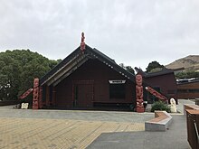
 Te Rāpaki-o-Te Rakiwhakaputa, commonly known as Rāpaki or Rapaki, is a small settlement within the Lyttelton Harbour basin.[1] Rāpaki is one of four Banks Peninsula rūnanga (communities) based around marae (tribal meeting grounds).[2] The Rāpaki Marae, also known as Te Wheke Marae, is a meeting ground of Ngāi Tahu and its Hapū o Ngāti Wheke branch.[3] Its wharenui (meeting house), called Te Wheke, opened in 2008, was carved by Riki Manuel and Fayne Robinson, with tukutuku panels overseen by local weaver 'Aunty' Doe Parata.[4][5] The carvings of the wharenui trace the almost 400 years of continuous settlement related to the arrival of the ancestor Te Rakiwhakaputa.[5]  Rāpaki is overlooked by the peak Te Poho o Tamatea. According to one legend, the Ngāi Tahu chief Te Rakiwhakaputa named the place by laying his waist mat (rāpaki) down to claim it.[2] The full name of Rāpaki is Te Rāpaki-o-Te Rakiwhakaputa, meaning the waist mat of Te Rakiwhakaputa.[6] On 8 July 2020, the New Zealand Geographic Board assigned the full name as the official name of the locality.[7] ReferencesWikimedia Commons has media related to Rapaki.
43°36′14″S 172°40′46″E / 43.6040°S 172.6795°E
|