Share to: share facebook share twitter share wa share telegram print page


Petit Manan National Wildlife Refuge

Petit Manan National Wildlife Refuge
IUCN category IV (habitat/species management area)
Petit Manan National Wildlife Refuge
Map showing the location of Petit Manan National Wildlife Refuge
Map of the United States
LocationHancock County, Washington County, Maine, United States
Nearest citySteuben, Maine
Coordinates44°26′10″N 67°53′52″W / 44.43619°N 67.89777°W / 44.43619; -67.89777[1]
Area6,367 acres (25.77 km2)
Established1974
Governing bodyU.S. Fish and Wildlife Service
WebsitePetit Manan National Wildlife Refuge

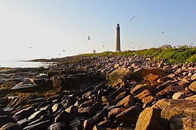
Petit Manan National Wildlife Refuge is a National Wildlife Refuge in the state of Maine. It is one of the five refuges that together make up the Maine Coastal Islands National Wildlife Refuge, along with Cross Island, Franklin Island, Seal Island, and Pond Island.

Geography

Petit Manan NWR has a surface area of 6,367 acres (25.77 km2).[2] It is part of the town of Steuben.

The refuge has four mainland divisions. The 2,195-acre (8.88 km2) Petit Manan Point Division. The Gouldsboro Bay Division protects 623 acres (2.52 km2). The 1,028-acre (4.16 km2) Sawyer's Marsh Division. The 431-acre (1.74 km2) Corea Heath Division.

Petit Manan NWR includes 2,078 acres (8.41 km2) acres on 41 islands, stretching the entire coastline of Maine.

References

  1. ^ "Petit Manan National Wildlife Refuge". Geographic Names Information System. United States Geological Survey, United States Department of the Interior.
  2. ^ USFWS Lands Report, 30 September 2007

Public Domain This article incorporates public domain material from websites or documents of the United States Fish and Wildlife Service.


Kembali kehalaman sebelumnya