Share to: share facebook share twitter share wa share telegram print page


Namsai district

Namsai district
Golden pagoda in Namsai
Map
Namsai district
Location in Arunachal Pradesh
Coordinates (Namsai, India|Namsai): 27°40′08″N 95°52′17″E / 27.6689°N 95.8714°E / 27.6689; 95.8714
CountryIndia
StateArunachal Pradesh
Established25 November 2014 (2014-11-25)
HeadquartersNamsai
Government
 • Lok Sabha constituenciesArunachal East
 • Vidhan Sabha constituencies
  • 46. Chowkham (ST)
  • 47. Namsai (ST)
  • 48. Lekang (ST)
Area
 • Total
1,587 km2 (613 sq mi)
Population
 (2011)[1]
 • Total
95,950
 • Density60/km2 (160/sq mi)
Demographics
 • Literacy54.24%[1]
 • Sex ratio984.49[1]
Time zoneUTC+05:30 (IST)
Average annual precipitation3500-4000[1] mm
Websitenamsai.nic.in

Namsai district is an administrative district in the state of Arunachal Pradesh in north-east India.It was carved out of Lohit district in November 2014.[2]

History
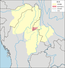
Namsai district under the kingdom of Mong Mao (yellow) in the heyday of the Si Kefa period (1360)

The creation of Namsai district was approved by the Arunachal Pradesh government of Nabam Tuki on 21 March 2013.[3]

On 25 November 2014, the Namsai subdivision of Lohit district was declared as a new district of Arunachal Pradesh, becoming the 18th district of the state.[2]

Demographics

Religion

Religion in Namsai (2011)[4]

  Hinduism (63.17%)
  Buddhism (22.05%)
  Christianity (7.06%)
  Islam (1.91%)
  Others (5.81%)

References

  1. ^ a b c d "Namsai at a Glance". Retrieved 26 December 2018.
  2. ^ a b "Namsai became the 18th district of Arunachal Pradesh in November 2014". India Today. 18 December 2014. Retrieved 26 October 2015.
  3. ^ "Arunachal clears bill for four new districts". The Times of India. 22 March 2013.
  4. ^ "Population by religion community – 2011". Census of India, 2011. The Registrar General & Census Commissioner, India. Archived from the original on 25 August 2015.
Kembali kehalaman sebelumnya