Share to: share facebook share twitter share wa share telegram print page


Hartland, Connecticut

Hartland, Connecticut
Town of Hartland
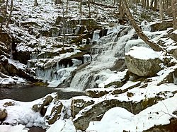
Falls Brook in the Tunxis State Forest
Official seal of Hartland, Connecticut
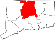
Hartland's location within Hartford County and Connecticut
Map
Map
Map
Coordinates: 42°00′18″N 72°56′53″W / 42.00500°N 72.94806°W / 42.00500; -72.94806
Country United States
U.S. state Connecticut
CountyHartford
RegionNorthwest Hills
Settled1754
Incorporated1761
VillagesEast Hartland
West Hartland
Government
 • TypeSelectman-town meeting
 • First SelectmanMagi Winslow (D)
 • SelectmanScott M. Levan (R)
 • SelectmanGregory M. Sottile (D)
Area
 • Total
34.6 sq mi (89.6 km2)
 • Land33.1 sq mi (85.7 km2)
 • Water1.5 sq mi (3.9 km2)
Elevation
531 ft (162 m)
Population
 (2020)[1]
 • Total
1,901
 • Density55/sq mi (21/km2)
Time zoneUTC-5 (Eastern)
 • Summer (DST)UTC-4 (Eastern)
ZIP Codes
06027, 06091
Area code(s)860/959
FIPS code09-37140
GNIS feature ID0213443[1]
Websitewww.hartlandct.org

Hartland is a town in Hartford County, Connecticut, United States. The population was 1,901 at the 2020 census.[2] The rural town is part of the Northwest Hills Planning Region and forms the northwestern border of Hartford County. Currently, the town consists of two unincorporated areas, East and West Hartland, entirely separated by the northern portion of the Barkhamsted Reservoir. A third area, Hartland Hollow (also referred to as Hartland Center), was flooded when the reservoir was completed in 1940.

History

Originally referenced as the "Western Lands," the unsettled area was the subject of a 37-year controversy over competing claims by the Connecticut Colony and the towns of Hartford and Windsor.[3] After the Colony's General Court was petitioned in 1724 to settle the dispute, it divided the lands among the three parties, which was followed by a confirming patent issued by Governor Joseph Talcott in 1729.

After another division agreement, Hartford's proprietors were granted a patent in 1732 for four parcels encompassing the lands now known as Hartland, Winchester, and New Hartford. Land in Hartland was proportionally granted on the basis of Hartford's 1720 Grand List. In 1733, the 67 landowners organized the Proprietors of Hartland association, and received a decree from the General Court for "Hartford land," then shortened to Hartland.[4]

In 1754, Captain/Deacon Thomas Giddings Jr II (1723 -1790) and his wife Mary Coult became the town's first permanent settlers.[3] In 1761, the 44 families of Hartland petitioned the General Court, and Hartland was incorporated as an independent town that same year.[5]

Geography

The town is bisected by the Farmington River's east branch which became the northern section of Barkhamsted Reservoir after construction of the Saville Dam in 1940.[6] The reservoir and surrounding land, owned by the Metropolitan District Commission (MDC) water authority, fills the hollow between East and West mountains.

According to the United States Census Bureau, the town has a total area of 34.6 square miles (89.6 km2), of which 33.1 square miles (85.7 km2) is land and 1.5 square miles (3.9 km2), or 4.39%, is water.[7] Bounded on the north by the Massachusetts border, Hartland is drained by the Farmington River, a tributary of the Connecticut River. The 42nd parallel north and the 73rd meridian west meet in the central western part of town.

Hartland is home to parts of three Connecticut State forests, Peoples State Forest, Tunxis State Forest, and American Legion State Forest[8] The Barkhamsted Reservoir, which cuts through the middle of Hartland, is 11 miles long and holds approximately 30 billion gallon reservoir, and serves the primary source of drinking water for most of Hartford County. The construction of the reservoir and the Saville Dam required the relocation of over 1,000 people, four cemeteries, and numerous family farms in Hartland and Barkhamsted.[6] In total, over 70% of Hartland's land, or over 15,500 acres, is permanently designated as open space, encompassing state forests and parks, watersheds, and public land conservation trusts.[9]

Demographics

Congregational Church, East Hartland
Historical population
CensusPop.Note
18001,318
18101,284−2.6%
18201,254−2.3%
18301,221−2.6%
18401,060−13.2%
1850848−20.0%
1860846−0.2%
1870789−6.7%
1880643−18.5%
1890565−12.1%
19005924.8%
1910544−8.1%
1920448−17.6%
1930296−33.9%
19403001.4%
195054983.0%
19601,04089.4%
19701,30325.3%
19801,4168.7%
19901,86631.8%
20002,0127.8%
20102,1145.1%
20201,901−10.1%
[10]

As of the U.S. Census Bureau's 2023 American Community Survey,[11] there were 1,971 people and 818 households residing in the town. The population density was 60 people per square mile (23.2/km2). There were 923 housing units, of which 840 (91%) were owner-occupied. The racial makeup of the town was 89% White, less than 1% African American, less than 1% Asian, 10% from other races and two or more races. Hispanic or Latino of any race were less than 1% of the population.

The population distribution in 2023 was 18.82% (397) age 19 and under, 8.22% (162) ages 20 to 29, 9.79% (193) ages 30 to 39, 9.49% (187) ages 40 to 49, 19.13% (377) ages 50 to 59, 22.83% (450) ages 60 to 69, 6.50% (137) ages 70 to 79, and 3.45% (68) who were 80 years of age or older. Median age was 52.

The median household income was $105,921. 2% of the population were below the poverty line. As of 2022, 2.16% (40) of the town qualified for Supplemental Nutritional Assistance Program (SNAP).[12]

Education

Educational data is provided by the Connecticut Economic Resource Center (CERC). Hartland School District consists of one school, Hartland School, Pre-K through grade eight, with an enrollment in 2017 of 162. High school students can attend any of the CREC magnet schools, State of Connecticut vocational schools, State of Connecticut vocational-agricultural schools, the town-designated public high school (Granby High School as of 2019), or receive a voucher to attend another town public high school. Because of the wide variety in high school choice, four-year cohort graduation rates were not available. From 2013 to 2017, 73.1% of students attended public school, while 26.9% attended private school. By highest education level achieved as of 2017, 32% of the town earned a high school diploma, 12% an associate degree, and 32% bachelor's degree or higher.[13]

Government

Hartland is governed by a three-person, elected Board of Selectman with supporting elected town boards for Finance, Education, and Library. The remaining boards and committees, including Planning & Zoning, Wetlands, and Recreation, are appointed by the Board of Selectman. Total Revenues for 2017 was $7,217,096, with total expenditures of $6,988,601 including $115,495 (1.7% of expenditures) for debt (bond) service. Hartland is rated A1 by Moody's and conveys a mill rate of 25.50 on a net Grand List of $198,192,769. Of the net Grand List, 1.3% is commercial/industrial.[13]

Voter Registration and Party Enrollment as of November 5, 2018[14]
Party Active Voters Inactive Voters Total Voters Percentage
Republican 626 29 655 40.89%
Democratic 332 15 347 21.66%
Minor Parties 31 1 32 2.00%
Unaffiliated 539 29 568 35.46%
Total 1,528 74 1,602 100%

Politics

Hartland has published results for all presidential elections since 1856. From 1856 to 1876, Hartland supported Democratic candidates for president except for Abraham Lincoln received in the four-way race in 1860.[15] Since 1880, Hartland voters have supported the Republican presidential candidate for 36 consecutive elections.[15] As of 2022, Hartland had the largest share of registered Republican voters in the state, at 40% of the electorate.[16]

Hartland town vote
by party in presidential elections[15]
Year Democratic Republican Third Parties
2020[17] 35.39% 457 63.66% 818 1.24% 16
2016[18] 28.19% 349 64.94% 804 6.87% 85
2012[19] 34.36% 414 64.56% 778 1.08% 13
2008[20] 38.87% 496 59.25% 756 1.88% 24
2004[21] 37.15% 435 60.46% 708 2.39% 28
2000[22] 36.60% 388 54.81% 581 8.59% 91
1996[23] 32.31% 317 50.56% 496 17.13% 168
1992[24] 28.42% 303 42.96% 458 28.61% 305*
1988[25] 35.25% 318 63.97% 577 0.78% 7
1984[26] 22.97% 181 76.40% 602 0.63% 5
1980[27] 25.83% 178 57.62% 397 16.55% 114
1976[28] 33.12% 206 66.24% 412 0.64% 4
1972[29] 21.31% 130 77.71% 474 0.98% 6
1968[30] 26.12% 146 67.26% 376 6.62% 37
1964[31] 43.01% 203 56.99% 269 0.00% 0
1960[32] 21.03% 98 78.70% 362 0.00% 0
1956[33] 13.23% 52 86.77% 341 0.00% 0
1952[34] 17.47% 58 82.53% 274 0.00% 0
1948[35] 21.27% 47 78.28% 173 0.45% 1
1944[36] 25.98% 53 74.02% 151 0.00% 0
1940[37] 31.71% 52 68.29% 112 0.00% 0
1936[38] 27.88% 40 72.22% 104 0.00% 0
1932[39] 24.31% 35 75.69% 109 0.00% 0
1928[40] 17.56% 23 82.44% 108 0.00% 0
1924[41] 17.89% 22 79.67% 98 2.44% 3
1920[42] 18.87% 20 80.19% 85 0.94% 1
1916[42] 38.00% 38 59.00% 59 3.00% 3
1912[43] 38.00% 38 49.00% 49 13.00% 13
1908[43] 25.56% 23 73.33% 66 1.11% 1
1904[44] 23.64% 26 73.64% 81 2.73% 3
1900[44] 23.16% 22 76.84% 73 0.00% 0
1896[45] 20.80% 26 67.20% 84 12.00% 15
1892[45] 35.81% 53 62.84% 93 1.35% 2
1888[46] 42.01% 71 56.21% 95 1.78% 3
1884[46] 45.50% 86 52.89% 100 1.59% 3
1880[46] 48.57% 85 51.43% 90 0.00% 0
1876[46] 64.71% 110 35.29% 60 0.00% 0
1872[46] 61.97% 88 38.03% 54 0.00% 0
1868[46] 60.22% 109 39.78% 72 0.00% 0
1864[46] 55.50% 106 44.50% 85 0.00% 0
1860[46] 39.49% 62 47.13% 74 13.38% 21
1856[46] 49.74% 96 47.67% 92 2.59% 5

Notable locations

Notable people

References

  1. ^ a b U.S. Geological Survey Geographic Names Information System: Hartland, Connecticut
  2. ^ "Census - Geography Profile: Hartland town, Hartford County, Connecticut". United States Census Bureau. Retrieved December 16, 2021.
  3. ^ a b "History of Hartland". Hartland Historical Society. Retrieved December 16, 2023.
  4. ^ "Town of Hartland, Connecticut". Town of Hartland, Connecticut. Retrieved December 16, 2023.
  5. ^ Hartford Courant (July 25, 1996). "Hartland". Hartford Courant. Retrieved September 15, 2019.
  6. ^ a b "Barkhamsted Reservoir Construction Washes Away a Community". December 21, 2020. Retrieved June 19, 2021.
  7. ^ "Geographic Identifiers: 2010 Demographic Profile Data (G001): Hartland town, Hartford County, Connecticut". U.S. Census Bureau, American Factfinder. Archived from the original on February 12, 2020. Retrieved November 28, 2012.
  8. ^ "Department of Energy & Environmental Protection Property" (PDF). January 2014.
  9. ^ "MAP: How Much of Your Town Is Open Space?". Brookfield, CT Patch. April 13, 2014. Retrieved June 19, 2021.
  10. ^ "Annual Town and County Population for Connecticut". ct.gov. CT State Department of Public Health. Retrieved December 22, 2023.
  11. ^ "2023 Town Profile Hartland, Connecticut" (PDF). profiles.ctdata.org. CTData Collaborative. Retrieved December 22, 2023.
  12. ^ "SNAP Enrollment by Town" (PDF). cga.ct.gov. February 16, 2022. Retrieved December 22, 2023.
  13. ^ a b "Connecticut Economic Resource Center 2019 Town Profile for Hartland CT" (PDF). Retrieved November 1, 2019.
  14. ^ "Registration and Party Enrollment Statistics as of November 5, 2018" (PDF). Connecticut Secretary of State. Retrieved November 1, 2019.
  15. ^ a b c "General Election Statements of Vote, 1922 – Current". CT Secretary of State. Retrieved December 16, 2023.
  16. ^ "MAPS: How has political affiliation in CT's towns changed from 2012-2022?". CT Mirror. February 2, 2023. Retrieved December 16, 2023.
  17. ^ "State of Connecticut 2020 Statement of Vote" (PDF). 2020.
  18. ^ "State of Connecticut 2016 Statement of Vote" (PDF). 2016.
  19. ^ "State of Connecticut 2012 Statement of Vote" (PDF). 2012.
  20. ^ "State of Connecticut 2008 Statement of Vote" (PDF). 2008.
  21. ^ "State of Connecticut 2004 Statement of Vote" (PDF). 2004.
  22. ^ "State of Connecticut 2000 Statement of Vote" (PDF). 2000.
  23. ^ "State of Connecticut 1996 Statement of Vote" (PDF). 1996.
  24. ^ "State of Connecticut 1992 Statement of Vote" (PDF). 1992.
  25. ^ "State of Connecticut 1988 Statement of Vote" (PDF). 1988.
  26. ^ "State of Connecticut 1984 Statement of Vote" (PDF). 1984.
  27. ^ "State of Connecticut 1980 Statement of Vote" (PDF). 1980.
  28. ^ "State of Connecticut 1976 Statement of Vote" (PDF). 1976.
  29. ^ "State of Connecticut 1972 Statement of Vote" (PDF). 1972.
  30. ^ "State of Connecticut 1968 Statement of Vote" (PDF). 1968.
  31. ^ "State of Connecticut 1964 Statement of Vote" (PDF). 1964.
  32. ^ "State of Connecticut 1960 Statement of Vote" (PDF). 1960.
  33. ^ "State of Connecticut 1956 Statement of Vote" (PDF). 1956.
  34. ^ "State of Connecticut 1952 Statement of Vote" (PDF). 1952.
  35. ^ "State of Connecticut 1948 Statement of Vote" (PDF). 1948.
  36. ^ "State of Connecticut 1944 Statement of Vote" (PDF). 1944.
  37. ^ "State of Connecticut 1940 Statement of Vote" (PDF). 1940.
  38. ^ "State of Connecticut 1936 Statement of Vote" (PDF). 1936.
  39. ^ "State of Connecticut 1932 Statement of Vote" (PDF). 1932.
  40. ^ "State of Connecticut 1928 Statement of Vote" (PDF). 1928.
  41. ^ "State of Connecticut 1924 Statement of Vote" (PDF). 1924.
  42. ^ a b "State of Connecticut register and manual". Register and Manual. 1921.
  43. ^ a b "State of Connecticut register and manual". Register and Manual. 1913.
  44. ^ a b "State of Connecticut register and manual". Register and Manual. 1907.
  45. ^ a b "State of Connecticut register and manual". Register and Manual. 1897.
  46. ^ a b c d e f g h i "State of Connecticut register and manual". Register and Manual. 1889.

Further reading

Kembali kehalaman sebelumnya