Share to: share facebook share twitter share wa share telegram print page


Hardricourt

Hardricourt
Town hall
Town hall
Coat of arms of Hardricourt
Location of Hardricourt
Map
Hardricourt is located in France
Hardricourt
Hardricourt
Hardricourt is located in Île-de-France (region)
Hardricourt
Hardricourt
Coordinates: 49°00′32″N 1°53′40″E / 49.0089°N 1.8944°E / 49.0089; 1.8944
CountryFrance
RegionÎle-de-France
DepartmentYvelines
ArrondissementMantes-la-Jolie
CantonLes Mureaux
IntercommunalityCU Grand Paris Seine et Oise
Government
 • Mayor (2020–2026) Yann Scotte[1]
Area
1
3.28 km2 (1.27 sq mi)
Population
 (2021)[2]
2,480
 • Density760/km2 (2,000/sq mi)
Time zoneUTC+01:00 (CET)
 • Summer (DST)UTC+02:00 (CEST)
INSEE/Postal code
78299 /78250
Elevation18–118 m (59–387 ft)
(avg. 58 m or 190 ft)
1 French Land Register data, which excludes lakes, ponds, glaciers > 1 km2 (0.386 sq mi or 247 acres) and river estuaries.

Hardricourt (French pronunciation: [aʁdʁikuʁ]) is a commune in the Yvelines department in the Île-de-France region in north-central France.

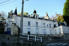
The castle of Hardricourt was between 1970 and 2011 the property of Jean-Bedel Bokassa, from 1966 dictator and between 1977 and 1979 self-appointed emperor of the Central African Republic. He was overthrown in 1977 and, after a period in the Ivory Coast, lived in the castle in exile from c. 1983 to 1986.[3]

Population

Historical population
YearPop.±% p.a.
1968 1,431—    
1975 1,636+1.93%
1982 1,568−0.60%
1990 1,989+3.02%
1999 1,918−0.40%
2007 1,978+0.39%
2012 2,070+0.91%
2017 2,289+2.03%
Source: INSEE[4]

See also

References

  1. ^ "Répertoire national des élus: les maires" (in French). data.gouv.fr, Plateforme ouverte des données publiques françaises. 4 May 2022.
  2. ^ "Populations légales 2021" (in French). The National Institute of Statistics and Economic Studies. 28 December 2023.
  3. ^ Le Château d'Hardricourt
  4. ^ Population en historique depuis 1968, INSEE


Kembali kehalaman sebelumnya