Share to: share facebook share twitter share wa share telegram print page


Griffiths-Priday State Park

Griffiths-Priday State Park
Dunes with ocean and Copalis Rock in the distance
Map showing the location of Griffiths-Priday State Park
Location in the state of Washington
Map showing the location of Griffiths-Priday State Park
Griffiths-Priday State Park (the United States)
LocationGrays Harbor, Washington, United States
Coordinates47°07′49″N 124°10′39″W / 47.13028°N 124.17750°W / 47.13028; -124.17750[1]
Area364 acres (147 ha)
Elevation75 ft (23 m)[1]
EstablishedUnspecified
OperatorWashington State Parks and Recreation Commission
WebsiteGriffiths-Priday State Park

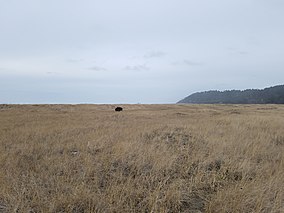
Griffiths-Priday State Park (formerly Griffiths-Priday Ocean State Park) is a 364-acre (147 ha) state-operated, public recreation area at the mouth of the Copalis River on the Pacific Ocean in Grays Harbor County, Washington. The park has beach, low dunes, and 8,316 feet (2,535 m) of ocean shoreline plus 9,950 feet (3,030 m) of freshwater river shoreline along both the Copalis River and the adjacent Connor Creek. The park includes the Copalis Spit, a small peninsula that serves as refuge for migratory birds. Park activities include picnicking, fishing, clam digging, beachcombing, birdwatching, mountain biking, and wildlife viewing,[2] including migratory gray whales.

References

  1. ^ a b "Griffiths-Priday Ocean State Park". Geographic Names Information System. United States Geological Survey, United States Department of the Interior.
  2. ^ "Griffiths-Priday Ocean State Park". Washington State Parks and Recreation Commission. Archived from the original on February 12, 2015. Retrieved February 5, 2015.
Kembali kehalaman sebelumnya