Share to: share facebook share twitter share wa share telegram print page


Dobrești, Bihor

Dobrești
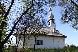
Wooden church in Luncasprie village
Location in Bihor County
Dobrești is located in Romania
Dobrești
Dobrești
Location in Romania
Coordinates: 46°50′51″N 22°16′44″E / 46.8474°N 22.2788°E / 46.8474; 22.2788
CountryRomania
CountyBihor
Government
 • Mayor (2020–2024) Florin Copos (PNL)
Area
133.48 km2 (51.54 sq mi)
Elevation
161 m (528 ft)
Population
 (2021-12-01)[1]
5,307
 • Density40/km2 (100/sq mi)
Time zoneEET/EEST (UTC+2/+3)
Postal code
417240
Area code+40 x59
Vehicle reg.BH

Dobrești (Hungarian: Bihardobrosd) is a commune in Bihor County, Crișana, Romania with a population of 5,260 people (2011). It is composed of eight villages: Cornișești (Nagykerpesd), Crâncești (Karáncsfalva), Dobrești, Hidișel (Nánhegyes), Luncasprie (Lankás), Răcaș (Lankástanya), Topa de Jos (Alsótopa), and Topa de Sus (Felsőtopa).

Geography

The commune is located in the south-central part of Bihor County, 47 km (29 mi) southeast of the county seat, Oradea. Dobrești is situated in the foothills of the Pădurea Craiului Mountains. It lies on the banks of the river Holod, and its right tributary, the river Topa; the river Valea lui Vasile flows into the Topa in Hidișel village.

Economy

The Dobrești mine is located on the territory of the commune. Opened in 1965, the mine, which employed 2,000 workers, produced 140,000 tonnes of bauxite per year; the mine closed in 1999.[2]

References

  1. ^ "Populaţia rezidentă după grupa de vârstă, pe județe și municipii, orașe, comune, la 1 decembrie 2021" (XLS). National Institute of Statistics.
  2. ^ Deac, Anca (June 18, 2018). "Clădiri abandonate, singurele rămase dintr-o întreprindere minieră profitabilă în perioada comunistă". Digi24 (in Romanian). Retrieved November 5, 2022.
Wooden church in Topa de Jos village
Topa de Jos
Kembali kehalaman sebelumnya