Share to: share facebook share twitter share wa share telegram print page


Colpo

Colpo
Kolpoù
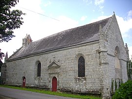
The Chapelle Notre-Dame de Kerdroguen
Coat of arms of Colpo
Location of Colpo
Map
Colpo is located in France
Colpo
Colpo
Colpo is located in Brittany
Colpo
Colpo
Coordinates: 47°49′12″N 2°48′32″W / 47.82°N 2.8089°W / 47.82; -2.8089
CountryFrance
RegionBrittany
DepartmentMorbihan
ArrondissementVannes
CantonGrand-Champ
IntercommunalityGolfe du Morbihan - Vannes Agglomération
Government
 • Mayor (2020–2026) Freddy Jahier[1]
Area
1
26.48 km2 (10.22 sq mi)
Population
 (2021)[2]
2,237
 • Density84/km2 (220/sq mi)
Time zoneUTC+01:00 (CET)
 • Summer (DST)UTC+02:00 (CEST)
INSEE/Postal code
56042 /56390
Elevation52–156 m (171–512 ft)
1 French Land Register data, which excludes lakes, ponds, glaciers > 1 km2 (0.386 sq mi or 247 acres) and river estuaries.

Colpo (French pronunciation: [kɔlpo]; Breton: Kolpoù) is a commune in the Morbihan department of the region of Brittany in north-western France.[3]

Demographics

Inhabitants of Colpo are called Colpéens.

Historical population
YearPop.±% p.a.
1866 973—    
1872 1,000+0.46%
1876 1,286+6.49%
1881 1,016−4.60%
1886 1,106+1.71%
1891 1,157+0.91%
1896 1,161+0.07%
1901 1,203+0.71%
1906 1,232+0.48%
1911 1,268+0.58%
1921 1,234−0.27%
1926 1,177−0.94%
1931 1,246+1.15%
YearPop.±% p.a.
1936 1,254+0.13%
1946 1,308+0.42%
1954 1,230−0.77%
1962 1,222−0.08%
1968 1,231+0.12%
1975 1,158−0.87%
1982 1,378+2.52%
1990 1,659+2.35%
1999 1,809+0.97%
2009 2,216+2.05%
2014 2,247+0.28%
2020 2,216−0.23%
Source: EHESS[4] and INSEE (1968-2020)[5]

Map

Topographic map

See also

References

  1. ^ "Maires du Morbihan" (PDF). Préfecture du Morbihan. 7 July 2020.
  2. ^ "Populations légales 2021" (in French). The National Institute of Statistics and Economic Studies. 28 December 2023.
  3. ^ INSEE commune file
  4. ^ Des villages de Cassini aux communes d'aujourd'hui: Commune data sheet Colpo, EHESS (in French).
  5. ^ Population en historique depuis 1968, INSEE


Kembali kehalaman sebelumnya