|
Borough of Charnwood
Charnwood is a local government district with borough status in the north of Leicestershire, England. It is named after Charnwood Forest, much of which lies within the borough. Towns in the borough include Loughborough (where the council is based), Shepshed and Syston. Villages in the borough include Barrow upon Soar, Birstall, Hathern, Mountsorrel, Quorn, Rothley, Sileby and Woodhouse Eaves. The neighbouring districts are Melton, Harborough, Leicester, Blaby, Hinckley and Bosworth, North West Leicestershire and Rushcliffe. HistoryThe district was created on 1 April 1974 under the Local Government Act 1972, covering the area of three former districts, which were all abolished at the same time:[2] Prior to the new district coming into being there was some debate as to what name it should take, with alternatives considered including "Loughborough and Soar Valley", "Greater Loughborough" and "Soar Valley".[3] A committee of the three outgoing councils chose Soar Valley as its preferred option but was overruled by the government, which went instead for the committee's second choice of Charnwood, after the Charnwood Forest which covers the western part of the district.[4][5] The new district was awarded borough status from its creation, allowing the chair of the council to take the title of mayor.[6] The symbol of Charnwood Borough Council is the fox, which is also the symbol used by Leicestershire County Council. Charnwood contains the village of Quorn, which gives its name to one of the country's oldest fox hunting packs, the Quorn Hunt, which was established in 1696 and moved to Quorn in 1753.[7] Governance
Charnwood Borough Council provides district-level services. County-level services are provided by Leicestershire County Council. Much of the borough is also covered by civil parishes, which form a third tier of local government.[10][11] Political controlThe council has been under no overall control since the 2023 election, being run by a Labour minority administration with support from the Greens.[12] The Leader of the Council is Jewel Miah. The first election to the council was held in 1973, initially operating as a shadow authority alongside the outgoing authorities before coming into its powers on 1 April 1974. Since 1974 political control of the council has been as follows:[13][14]
LeadershipThe role of mayor is ceremonial in Charnwood. Political leadership is instead provided by the Leader of the council. The Leaders since 2010 have been:[15]
CompositionFollowing the 2023 election the composition of the council was:[18][19]
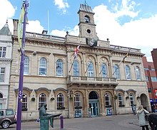
The next election is due in 2027. ElectionsSince the last boundary changes in 2023 the council has comprised 52 councillors, representing 24 wards, with each ward electing one, two or three councillors. Elections are held every four years.[20] There are three Parliamentary constituencies covering the district. Mid Leicestershire is represented by the Conservative Peter Bedford MP. Loughborough is represented by the Labour's Jeevun Sandher. Melton and Syston is represented by the Conservative Edward Argar MP. Premises The council is based at the Council Offices on Southfield Road in Loughborough. The older part of the building was an early 19th century house called Southfields.[21] The house was acquired by the old Loughborough Town Council during the Second World War and after the war was converted to be additional offices supplementing those at Loughborough Town Hall.[22] A large extension was added to Southfields in 1990 allowing it to become Charnwood's main offices.[23] Loughborough Town Hall is still used for full council meetings of Charnwood Borough Council.[24] GeographyTo the south it borders the City of Leicester, about 20 km away from Loughborough. There is a moderately urbanised A6 corridor between the two population centres and close to the River Soar, including Quorn, Barrow-on-Soar, Mountsorrel, Birstall, Sileby, Thurmaston, Syston, Queniborough and East Goscote. To the south of the borough, Birstall, Queniborough, Thurmaston and Syston form part of the Leicester Urban Area, while Quorn and Shepshed (the second-largest town in the district), amongst others, might be considered to be part of a Loughborough urban agglomeration. The highest point is Beacon Hill (248m/814 ft) to the north of the Charnwood Forest 'area of natural beauty' extending WN-west into the National Forest. DemographyCharnwood is the largest borough by population in Leicestershire,[25] and has the largest school population as well.
MediaThe area is served by BBC East Midlands and ITV Central with television signals received from the Waltham transmitter. [29] Radio stations for the area are:
ParishesMost of the borough is covered by civil parishes. Most of the pre-1974 borough of Loughborough is an unparished area. The parish councils for Shepshed and Syston have declared their parishes to be towns, allowing them to take the style "town council". The parishes of Barkby and Barkby Thorpe share a grouped parish council, as do Burton on the Wolds, Cotes and Prestwold. The small parishes of Beeby, Hamilton Lea, Stonebow Village, Swithland, Ulverscroft and Wanlip have a parish meeting rather than a parish council.[32]
Freedom of the BoroughThe following people, military units, and organisations and groups have received the Freedom of the Borough of Charnwood. Individuals
Military Units
Organisations and Groups
References
External linksWikimedia Commons has media related to Charnwood. |
|||||||||||||||||||||||||||||||||||||||||||||||||||||||||||||||||||||||||||||||||||||||||||||||||||||||||||||||||||||||||||||||||||||||||||||||||||||||||||||||||||||||||||||||||||||||||||||||||||||||||||


