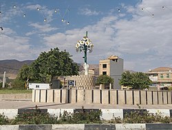
City in Fars province, Iran
City in Fars, Iran
Bab Anar (Persian : باب انار )[ a] Central District of Khafr County , Fars province, Iran , serving as capital of both the county and the district.[ 4] Khafr Rural District [ 5] Zarjan .[ 4]
Demographics
Population
At the time of the 2006 National Census, the city's population was 1,702 in 445 households,[ 6] Khafr District of Jahrom County .[ 7] [ 8] [ 2]
In 2019, the district was separated from the county in the establishment of Khafr County, and Bab Anar was transferred to the new Central District as the county's capital.[ 4]
See also
Iran portal
Notes
^ Also romanized as Bāb Anār and Bāb-e Anār ; also known as Bābā Anār , Bābā Na‘am , Bābā Najm , and Bāba Nār [ 3]
References
^ OpenStreetMap contributors (5 October 2024). "Bab Anar, Khafr County" (Map). OpenStreetMap . Retrieved 5 October 2024 . ^ a b Census of the Islamic Republic of Iran, 1395 (2016): Fars Province . amar.org.ir (Report) (in Persian). The Statistical Center of Iran. Archived from the original (Excel) on 6 April 2022. Retrieved 19 December 2022 .^ Bab Anar can be found at GEOnet Names Server , at this link , by opening the Advanced Search box, entering "-3054318" in the "Unique Feature Id" form, and clicking on "Search Database".
^ a b c Jahangiri, Ishaq (c. 2023) [Approved 7 October 1398]. Letter of approval regarding the national divisions of Jahrom County, Fars province . qavanin.ir (Report) (in Persian). Ministry of the Interior, Council of Ministers. Proposal 158364. Archived from the original on 22 September 2023. Retrieved 22 September 2023 – via Laws and Regulations Portal of the Islamic Republic of Iran. ^ Mousavi, Mirhossein (c. 2023) [Approved 18 May 1366]. Creation and establishment of 11 rural districts including villages, farms and places in a part of Jahrom County under Fars province . lamtakam.com (Report) (in Persian). Ministry of the Interior, Council of Ministers. Proposal 11673.1.5.53. Archived from the original on 8 December 2023. Retrieved 8 December 2023 – via Lam ta Kam. ^ Census of the Islamic Republic of Iran, 1385 (2006): Fars Province . amar.org.ir (Report) (in Persian). The Statistical Center of Iran. Archived from the original (Excel) on 20 September 2011. Retrieved 25 September 2022 .^ Habibi, Hassan (c. 2023) [Approved 21 June 1369]. Approval of the organization and chain of citizenship of the elements and units of the national divisions of Fars province, centered in Shiraz . lamtakam.com (Report) (in Persian). Ministry of the Interior, Council of Ministers. Notification 82840/T128K. Archived from the original on 7 December 2023. Retrieved 7 December 2023 – via Lam ta Kam. ^ Census of the Islamic Republic of Iran, 1390 (2011): Fars Province . irandataportal.syr.edu (Report) (in Persian). The Statistical Center of Iran. Archived from the original (Excel) on 16 January 2023. Retrieved 19 December 2022 – via Iran Data Portal, Syracuse University.


