Share to: share facebook share twitter share wa share telegram print page


Arvia'juaq and Qikiqtaarjuk National Historic Site

Arvia'juaq and Qikiqtaarjuk National Historic Site
Native name
ᕿᑭᖅᑖᕐᔪᒃ (Inuktitut)
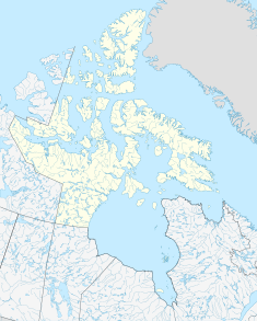
Arvia'juaq and Qikiqtaarjuk National Historic Site is located in Nunavut
Arvia'juaq and Qikiqtaarjuk National Historic Site
Location of Arvia'juaq and Qikiqtaarjuk National Historic Site in Nunavut
Typetraditional summer gathering place for the Caribou Inuit
LocationNunavut, Canada
Nearest cityArviat
Governing bodyParks Canada
Websitehttps://www.pc.gc.ca/apps/dfhd/page_nhs_eng.aspx?id=836
Designated6 July 1995[1]

The Arvia'juaq and Qikiqtaarjuk National Historic Site contains two areas: Arvia'Juaq and Qikiqtaaruk. Arvia'juaq (Sentry Island[2] 61°10′N 093°51′W / 61.167°N 93.850°W / 61.167; -93.850 (Sentry Island)[3]), an island in Hudson Bay, is located close to Arviat, Nunavut. It is a National Historic Site of Canada and a Caribou Inuit (Paallirmiut) summer camp site.[1] The site is co-managed between the community of Arviat and Parks Canada.[4]

Arvia'Juaq is a traditional summer camp of the Paallirmiut Inuit, and a virtual tour of the National Historic Site was made in 2017:[5]

Qikiqtaarjuk, (Inuktitut syllabics: ᕿᑭᖅᑖᕐᔪᒃ, Inuktitut for little island)[6] is a small peninsula, just north of Arviat, that faces Arvia'juaq.[4] Like Arvia'juaq, Qikiqtaarjuk contains many Paallirmiut artifacts and both are considered ritual, spiritual, and sacred sites. In particular Qikiqtaarjuk is associated with the Inuit hero figure Kiviuq.[4]

See also

References

  1. ^ a b "Arvia'juaq and Qikiqtaarjuk National Historic Site of Canada". Retrieved 2 September 2023.
  2. ^ "New Parks North". Archived from the original on 17 May 2008. Retrieved 22 December 2009.
  3. ^ "Sentry Island". Geographical Names Data Base. Natural Resources Canada.
  4. ^ a b c Arvia'juaq and Qikiqtaarjuk National Historic Site of Canada. Canadian Register of Historic Places. Retrieved 2009-12-22.
  5. ^ Porter, M. Cecilia (2017). "Arvia'juaq National Historic Site: A Case Study on Heritage and Virtual Tourism in the Canadian Arctic" (PDF).
  6. ^ Righting the Map: Mapping Inuit Place Names[permanent dead link]

61°08′23″N 093°59′36″W / 61.13972°N 93.99333°W / 61.13972; -93.99333 (Qikiqtaarjuk)


Kembali kehalaman sebelumnya