Share to: share facebook share twitter share wa share telegram print page


Agioi Anargyroi

Agioi Anargyroi
Άγιοι Ανάργυροι
Agioi Anargyroi is located in Greece
Agioi Anargyroi
Agioi Anargyroi
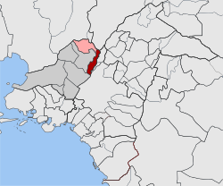
Location within West Athens regional unit
Coordinates: 38°1.6′N 23°43.1′E / 38.0267°N 23.7183°E / 38.0267; 23.7183
CountryGreece
Administrative regionAttica
Regional unitWest Athens
MunicipalityAgioi Anargyroi-Kamatero
Area
 • Municipal unit3.200 km2 (1.236 sq mi)
Elevation
70 m (230 ft)
Population
 (2021)[1]
 • Municipal unit
32,283
 • Municipal unit density10,000/km2 (26,000/sq mi)
Time zoneUTC+2 (EET)
 • Summer (DST)UTC+3 (EEST)
Postal code
135 xx
Area code(s)210
Vehicle registrationIB
Websitewww.agan.gov.gr

Agioi Anargyroi (Greek: Άγιοι Ανάργυροι) is a suburban town in the north-central part of the Athens agglomeration, Greece. It takes its name from the "Holy Unmercenaries": saints who received no payment for their medical services. Since the 2011 local government reform it is part of the municipality Agioi Anargyroi-Kamatero, of which it is the seat and a municipal unit.[2]

Geography

Proastiakos in Agioi Anargyroi coming from the airport to Athens

Agioi Anargyroi is located 5 km (3 mi) north of Athens city centre. The municipal unit has an area of 3.200 km2.[3] Its built-up area is continuous with that of municipality of Athens and the neighbouring suburbs Peristeri, Ilion, Kamatero, Acharnes, Nea Filadelfeia and Nea Chalkidona. The A1 motorway (Athens–Thessaloniki–Evzonoi) passes east of the town. Agioi Anargyroi has a station on the Athens–Thessaloniki railway. The old metric Piraeus–Patras railway passes through the town as well.

Historical population

Year Population
1971 26,094
1981 30,320
1991 30,739
2001 32,957
2011 34,168
2021 32,283

International relations

Agioi Anargyroi is twinned with:

References

  1. ^ "Αποτελέσματα Απογραφής Πληθυσμού - Κατοικιών 2021, Μόνιμος Πληθυσμός κατά οικισμό" [Results of the 2021 Population - Housing Census, Permanent population by settlement] (in Greek). Hellenic Statistical Authority. 29 March 2024.
  2. ^ "ΦΕΚ B 1292/2010, Kallikratis reform municipalities" (in Greek). Government Gazette.
  3. ^ "Population & housing census 2001 (incl. area and average elevation)" (PDF) (in Greek). National Statistical Service of Greece. Archived from the original (PDF) on 2015-09-21.
  4. ^ "Opole Official Website - Twin Towns". (in English and Polish) © 2007-2009 Urząd Miasta Opola. Archived from the original on 2014-02-01. Retrieved 2009-06-18.
Kembali kehalaman sebelumnya