ʻEua
| ʻEua | ||
|---|---|---|
 | ||
| Gwässer | Pazifische Ozean | |
| Inselgruppe | Tongatapu-Gruppe (Tonga-Insle) | |
| Geographische Lage | 21° 23′ S, 174° 56′ W | |
| ||
| Lengi | 19 km | |
| Breiti | 7,5 km | |
| Flechi | 86,7 km² | |
| Hechschti Hebi | Teʻemoa 312 m | |
| Iiwohner | 5206 (2006) 60 Einw./km² | |
| Hauptort | ʻOhonua | |
 | ||


ʻEua ghöört zu dr Inselgrubbe Tongatapu im Köönigriich Tonga. Es lit öbbe 40 km südöstlig vo dr Hauptinsle Tongatapu und isch geologisch äini vo de eltiste Insle im Pazifik.
Geografii
ʻEua isch 19 km lang, 7,5 km bräit und het e Flechi vo 86,7 km².[1]. 5'206 Iiwooner (Stand 2006) läbe dört in 15 Dörfer.[2]
Mä cha vo Nukuʻalofa us mit em Flugzüüg und Schiff uf d Insle choo. Mit em Schiff brucht mä öbbe drei Stunde. Dr grössti Ort und Divisionshauptort isch ʻOhonua (1626 Iiwohoner Taʻanga inkl.). Dört befinde sich alli Instituzioone vo dr Insle, dr Haafe Nafanua, zwäi Supermäärt, d Bost, e Bank und e Tankstell. D Insle het vier Underkünft. Die z Tufu isch gäignet für d Beobachtig vo Walfisch.
D Insle isch seer hügelig und uf eme Däil von ere waggst immer no dichte Räägewald. Dr höggst Punkt uf dr Insle isch dr Teʻemoa mit 312 m über em Meer. E Seenswürdigkäit isch äini vo de grösste und eltiste Birkefiige uf dr Wält.
Dr jöörlig Niiderschlaag lit bi 2700 mm, 2/3 drvo fallt wäärend dr Räägezit vo Novämber bis April.
Weblingg
- D Räägewaldvegetazion vo ʻEua Island (Site cha nüme abgrüeft wärde; Suche im Webarchiv) New Zealand Journal of Botany 1996, pdf (änglisch)
Einzelnachweise
- ↑ UNEP
- ↑ Kingdom of Tonga, Statistics Department: Results for Tonga Population Census 2006 (PDF; 161 kB)
Bildli
-
 Blick uf e Hauptort ʻOhonua, mit Walfisch im Vordergrund
 -
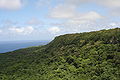 E groosse Däil vo dr Ostsite vo ʻEua ghört zum Eua National Park. Foto mit Blick gege Süde, von ere Blattform am Rand vom Park us.
 -
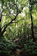 Räägewald uf ʻEua


Content Disclaimer
Informasi ini disarikan dari Wikipedia dan disajikan kembali untuk tujuan edukasi. Konten tersedia di bawah lisensi CC BY-SA 3.0. Kami tidak bertanggung jawab atas ketidakakuratan data yang bersumber dari kontribusi publik tersebut.
- The information displayed on this website is sourced in part or in whole from Wikipedia and has been adapted for the purpose of restating it. We strive to provide accurate and relevant information, however:
- There is no guarantee of absolute accuracy. Wikipedia is an open, collaborative project that can be edited by anyone, so information is subject to change.
- It is not intended to constitute professional advice. The content displayed is for informational and educational purposes only. For important decisions (e.g., medical, legal, or financial), please consult a professional.
- Content copyright. Wikipedia is licensed under the Creative Commons Attribution-ShareAlike License (CC BY-SA). This means that content may be reused with appropriate attribution and shared under a similar license.
- Responsible use. Any risk arising from the use of information from this website is entirely the responsibility of the user.